I’ve just looked at a thread about UAV Forecast minimum winds (Real world wind limits Phantom 4) which had something (but not what I wanted) about satellites.
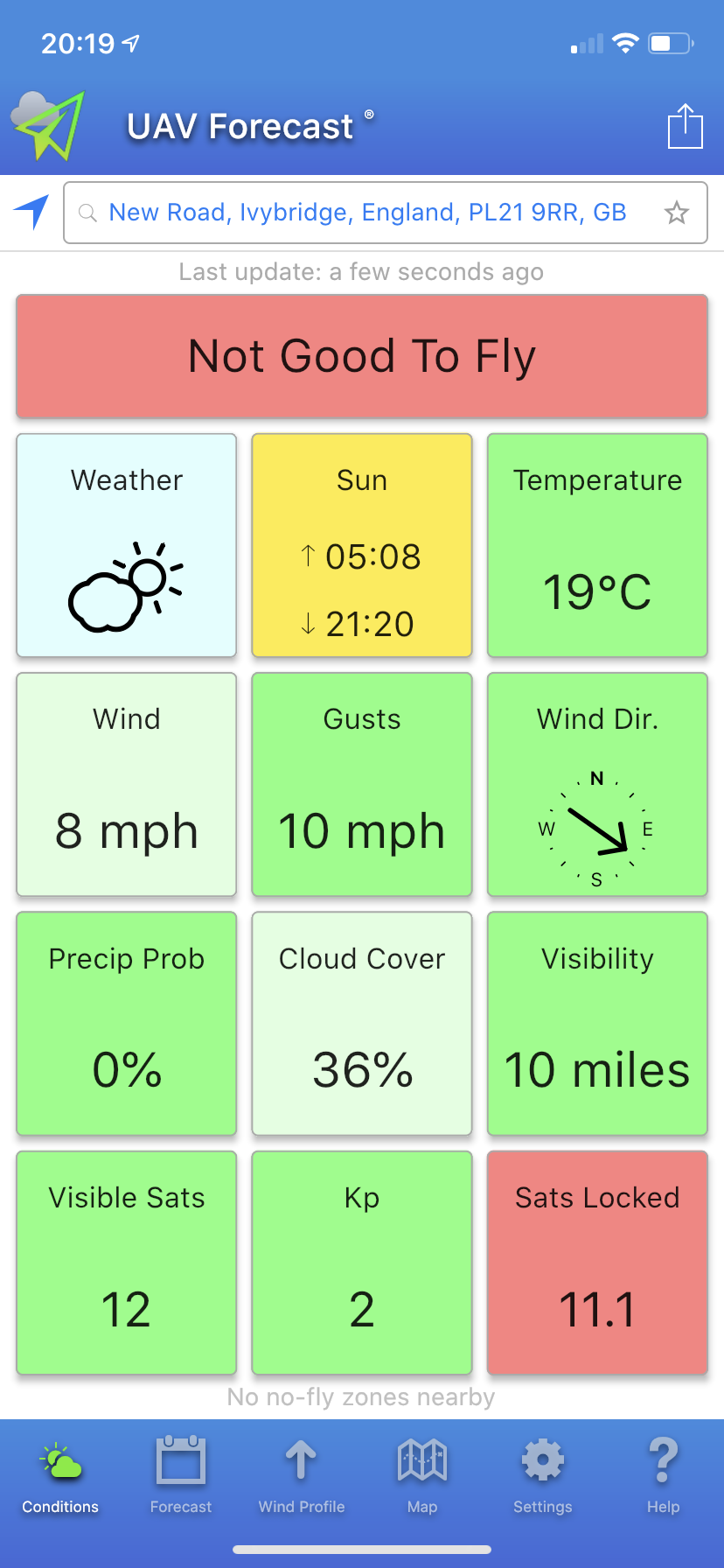
For those of you unfamiliar with the software it comes in desktop browser or phone app flavour and the free version gives you details of wind speed at pre-selected heights, precipitation, cloud cover and satellite cover over the next 24 hours at your location and a colour-coded go/nogo indication.
The default settings can be changed so the cautious can set a maximum wind speed of 5mph and those who like sport mode can set it at 30.
Tomorrow morning looks good for my purposes except it’s telling me that not enough satellites will be available.
I’ve RTF Mavic Air manual and it gives no definition of adequate satellite numbers, it only talks about good signal strength. The thread I was looking at said the Phantom would fly with just 6 which seems low to me.
TL;DR
What is the minimum number of satellites that YOU would be prepared to risk flying your UAV with?
Well, going back to my first real drone (Phantom 2 Vision+) it would not even take off unless you had a certain amount of Satellite’s (forget the exact number, I think it was 10)
These days with most drones using both American and Russian Sats you probably will not have any issues with the amount.
I would take what your App says ,with a big pinch of salts! and I would be sure to say that you will be able to fly with enough Sats around, contrary to what it says
That really is the key to all flights Richard,
once that announcement is heard you know that the RTH has been set, so should anything go wrong ,at least your Home point has been set for you to be able to get back safely.
You gave up on UAV Forecast? what was it getting wrong?
I have various wether sources, mainly Met Office, a weather radar app and data from a maritime station about a mile from me that gives tide and wave info as well as wind speed and direction. All good fun with speeds in knots, mph and metres per second.
Yes, sorry the way it reads it does look like I could have been referring to Go4, what I should have said is that I gave up on UAV Forecast, I didn’t find it all that accurate, I know at the end of the day it’s weather and it changes and you can only use some of these apps as a guide but I find it much easier to look out of the window now.
If Go4 tells me I’m good to go and I’ve checked the area then I make my own decision on the wind or sometimes use an anemometer.
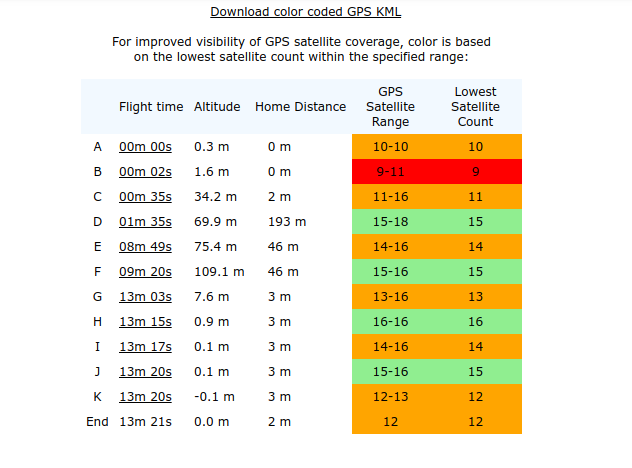
This is a post from my Airdata log from a flight I did today looking for a wee dog in woodland. Airdata seems to regard 11 to 16 as so-so and below 11 decidedly iffy. YMMV
I am using UAV app to check flight conditions. Often it tells me that there are not enough satellites locked. I know I can adjust the level, but what level do people recommend?
Does the phone you are using the UAV app on have capability for all of GPS, GLONASS and GALILEO satellite systems?
Your Parrot Anafi (from your profile) does (link) : Satellite navigation: GPS, GLONASS & GALILEO
So - if your phone doesn’t have GLONASS and/or GALILEO … it won’t be able to tell you how many your drone might be able to see. It’s only telling your what your phone is seeing.
Likewise - when using the app, make sure you are outside in a clear area … it can’t correctly advise you if you are indoors or a sheltered area.
That’s interesting, thank you. Does the UAV app rely on my phone? Or does it just forecast how many satellites will be available based on some other means?