Newbie from Wiltshire

Hey folks, Happy New Year to you all!

I’m a newbie to all this, picked up a cheap Hubsan H501S. I live in West Wiltshire, and am keen to learn more! Therefore I’m sure there will be lots of questions coming your way from me in the not too distant future :wink:

2 Likes

Hi @Kosymodo and welcome to Grey Arrows :wave:t2:

Have you seen our members map? (Click the burger-menu in the top right) You may find some pilots living near you. Feel free to add yourself to the members map too :+1:t2:

We’re a well established club with many knowledgeable members so it’s very likely that any issues you come across will have been discussed here before. Our discussion forum has very powerful search features which should help you find what you need but if you get stuck you can post a new question in the #questions-and-answers category.

Looking for recommendations of places to fly? Check out our interactive map on Drone Scene - be sure to log in to gain access to the full suite of features and map layers:

And please feel free to add locations of your own too.

Please also take a moment to look at the Membership Levels section on our FAQ as we’re quite different to other clubs and you’ll be eligible for some rather exclusive club discounts as your membership level increases :blush:

Welcome once again!

2 Likes

Welcome Nik. There are some stunning locations down your way. I was down there last week; Bratton Camp, Battlesbury Hillfort and Scratchbury Hillfort. Good luck.

1 Like

Thanks Chris - there certainly are some stunning locations, it’s just a case of working out whether I can fly at them! Many areas seem to be covered by the Salisbury Plain Training Area (including some of those you’ve mentioned?), and so flying over them seems impossible. Have you flown at these sites yourself?

1 Like

Hi Nik - welcome to GADC :+1: :+1: :+1:

1 Like

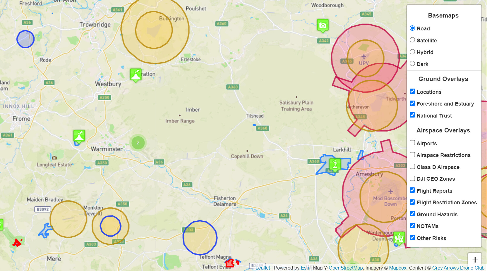
There was a similar post the other day where someone thought they couldn’t flying due to danger zones. Not sure if you have checked out Drone Scene yet, it’s in the link above that @milkmanchris posted. It is the #1 Swiss Army Knife for UAV pilots. I have added a screenshot below of your area, pay particular attention to the enabled filters - these are all you need.

As you can see, you have a shed loads of places to fly :wink:

Yes, and had a hell of time flying there :wink:

It can be a little overwhelming when starting off, especially where you can and cannot fly. If you use Drone Scene, you’ll be fine :+1:

2 Likes

Thanks again Chris!

I have to confess to being more than a little confused, but I take it this is par for the course! So can I take it that this is pretty much gospel, using the layers you’ve suggested? I’d previously looked at the Drone Scene map, but had kinda discounted it as being inaccurate, based on also looking at info given by an app called AirMap. I take your point though that the key thing is applying the layers properly.

I live on the doorstep of Cley Hill. This is the location flagged slightly WNW of the Warminster text on the screenshot you kindly prepared. I’d seen from my previous visit to the Drone Scene map that this had been added as a location. However, I also know that this is National Trust land, and there are physical signs on the gates saying drone flying is prohibited. (I know from looking on the forum today that there’s a whole separate lengthy thread about the NT!)

I guess if the sh!t hits the proverbial fan, I can just plead some kind of ignorance, and, as long as I’ve been following some decent common sense and the CAA guidelines, all should be fine?

Thanks again for taking the time to assist me, it’s very much appreciated :slight_smile:

I am sure others will chip have a view on this. But this is what I go by, and touch wood, this year I have been fine.

Blasphemy! :wink: I can’t speak for AirData (although the reviews here don’t bode well). Drone Scene is all you need, it uses your GADC credentials to log you in. It also has a very handy Good To Go section which determines whether you can fly a particular model of drone under particular circumstances, in accordance with the CAA rules.

Indeed. That’s what would do if the situation arose. The main thing is check Drone Scene before any flight, fly safely - and have fun :+1:

2 Likes

Hi to join drone Community. You ask any question u want ant time. Thanks

1 Like

Hello [Kosymodo, I’m also a noob to flying and live in this beautiful area. Lets hope we don’t get in trouble with the MoD!!

Welcome Chris! Indeed, let’s keep our fingers crossed! :rofl:

In all seriousness, I think with the advice from the knowledgable folk on here, we’ll be fine. I went up to Battlesbury yesterday, and had no issues at all (apart from it being very blustery!)

Did you! That’s great! I did wonder about up there… and Scratchbury but the other apps put it firmly in the red. I was so pleased to find this group and thier updates around the area. I saw both were ok with no permission needed but tbh, I didn’t believe it. Thank you for letting me know it is ok. Thats so good. You, my dear, have made my day. My hubby is going to be happy about this too :smiley:

1 Like

Red doesn’t always mean you can’t fly :+1:t2:

PingSpike, to my joy I have just realised! I’m overcautious by nature and assumed (you know what they say aboit asssumption!) red was total no go.

I’m really happy to have found this app/site and to discover this! I wish this weather would bugger off though!

1 Like

Well done, it’s a mighty walk up there - if you went the same way as I did, straight across from the car park up a 45 degree bank. Any photos?

Nah, you’re good to go. I’ve flown from both Battlesbury and Scratchbury. Get up there and have fun :wink:

1 Like

Thank Chris (I am also Chris, hello :slight_smile: )

May I ask a question about the sites please (hope you don’t mind Nik) Uh, I’m disabled, I have a leg that won’t behave, when it gets tired it just stops working. Which is the more easily accessable iyo?

I’m super excited about all this. I feel like a kid who has got the christmas bike they longed for all year only to have a month of rain and snow!

1 Like

Hello Chris!

Battlesbury is a lot harder to get up than Scratchbury. Apparently, there is an easier but longer walk to get up Battlesbury, but I went as the crow flies (an overweight crow with a 15kg backpack). Scratchbury is relatively easy, it is a shallow, gentle slope. But this time of year, the chalk gets wet and slippy by the turn stile, half way up :+1:

I can relate to that. I bought my Mavic Air 2, only 2 days before UK went into lockdown :man_facepalming: The lockdown went on and on … so I bought a Mini 2 and flew from my garden :wink:

1 Like

Battlesbury is harder …

Thank you Chris, that is super helpful to me! Scratchbury first then, I really want to do this so I WILL get to Battlesbury. It can be a goal for me.

Hah, I came in to the hobby from the other end, bought a tello and couldn’t use it for two weeks cos of bad weather so got the mini 2… and the weather got worse. My husband blames me lol!

1 Like

I think the easier route is below my yellow line, heading below the woods to the right. It then circles round (not visible in photo), and arrives at the top right of the hillfort.