Hi there! Before you post, have you selected the most appropriate category for your new topic? 
Having established that the RID on my Mini 4 Pro has a range of at least 160 metres from the controller, I decided to try the same experiment with my Air 3S, using DroneScan on my Google pixel 8a phone.
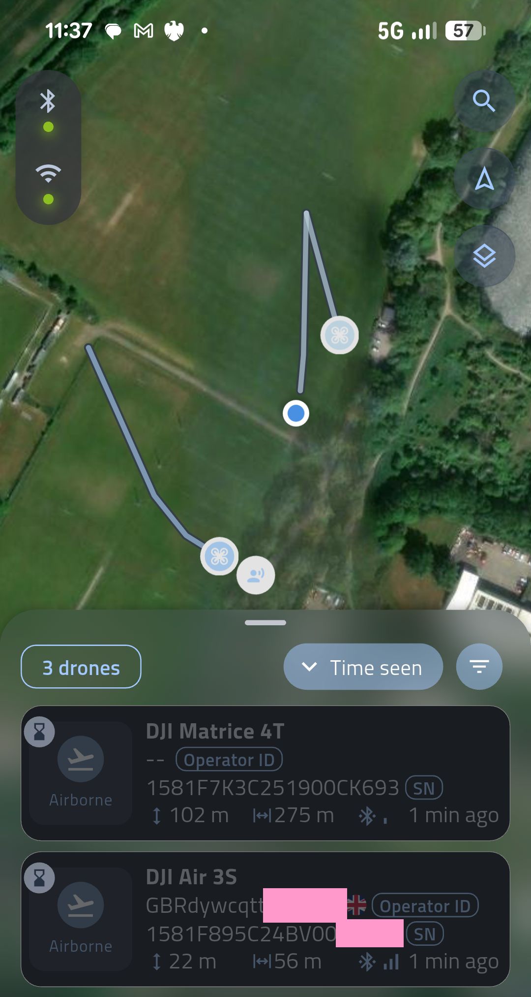
I set up as usual at my sports field test site, downloaded the image of the site for my controller, then turned the WiFi hotspot off so the drone wasn’t competing for the WiFi’s attention.
Sure enough, a drone quickly appeared on the screen. It was only when I did a double-take that I realised it wasn’t my drone. Somebody was flying a Matrice 4T over the other side of the field. This was the first time I had picked up another drone on my DroneScan. It was 275 metres away while my Air 3S was only 56 metres away.
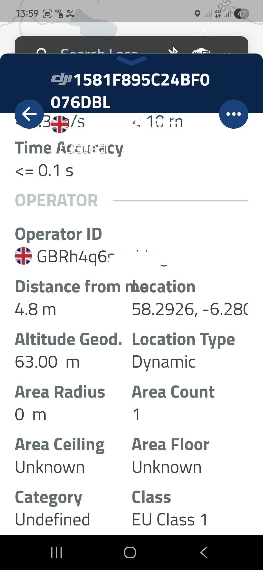
It wasn’t until I got home that I found the Matrice didn’t have an operator ID displayed. It may have been brand new and the owner hadn’t completed the details, or it may have been stolen. FWIW, these are the details from DroneScan:
few questions on the screen shot
1 - are you the blue dot or the little man icon here ? ( guess your the dot and the man is the M4T operator)
2- distance of 275m - is that from you or the distance that the drone flew from the operator ?
Kinda cool - be it a bit mmm scary do I say that the general public can see all this.
Surprised no one has come up with a $RID crypto currency with miners monitoring for the signals
The Matrice 4T doesn’t have a requirement to broadcast Remote ID until 2028, it’s all still legal at the moment.
The only requirement today is to have an Operator ID label stuck on it 
2 Likes
I’m the blue dot.
Not sure about the distance. Measuring from Google Earth’s ruler, drone to me is 152 metres, and drone to Mr M4T is 179 metres. With an interval between data bursts of about a minute, the data is old and of unknown accuracy.
The infrequent updates and dubious accuracy are limits of RID. At the moment, the only people who will benefit will be the lawyers.
Odd that the M4T would broadcast RID without user data - I’m sure my Air 3S would not broadcast RID data unless it had the Operator ID correctly set.
1 Like
Potensic’s RID is off if there’s no data and on when there is. Not sure if it validates the format of the data but it can be turned off using a Clear option to erase it.
Neither does the air 3 s but its still transmitting
I can’t seem to pick my Air 3S up using the Drone Scanner App. 
Wheres the evidence on the claim?
I have the Goggles 3
Maybe its your drone scanner app lol.
To be honest I was just curious and tried to try it. I’m not that particularly bothered
1 Like
I agree with the statement that RID is and can be useful.
As a slightly related example: I live in a rural spot with a local heliport nearby. There’s a small fleet of helis taking people to and from regional airports and events.
The flights near -and sometimes above - our village are obviously all tracked and available as public info. I do find this useful for multiple reasons, in particular when I see a helicopter flying at 60m height above a local field heading south. Not only does it give me safety info as a drone pilot, it also gives the general public some reassurance of what is happening around us. I think RID provides a similar service. I have on one occasion downed my drone when I heard helicopter noise. All the best planning only goes so far.