# Scratchbury Camp - Added to Iconic Landscapes and Ancient Sites in South West
**URL:** https://greyarro.ws/t/scratchbury-camp-added-to-iconic-landscapes-and-ancient-sites-in-south-west/40686
**Category:** Where to fly your drone in the UK
**Created:** [28 December 2021 22:34 UTC](https://greyarro.ws/t/scratchbury-camp-added-to-iconic-landscapes-and-ancient-sites-in-south-west/40686 "2021-12-28T22:34:42Z")
**Posts on this page:** 9
**Page:** 1
### Author:  [@clinkadink](https://greyarro.ws/u/clinkadink)
#### Post date: [28 December 2021 22:34 UTC](https://greyarro.ws/t/scratchbury-camp-added-to-iconic-landscapes-and-ancient-sites-in-south-west/40686/1 "2021-12-28T22:34:42Z")
I have just added this to the map of places to fly your drone at [Drone Scene](https://dronescene.co.uk/where-to-fly-drone/scratchbury-camp/south-west/1594):
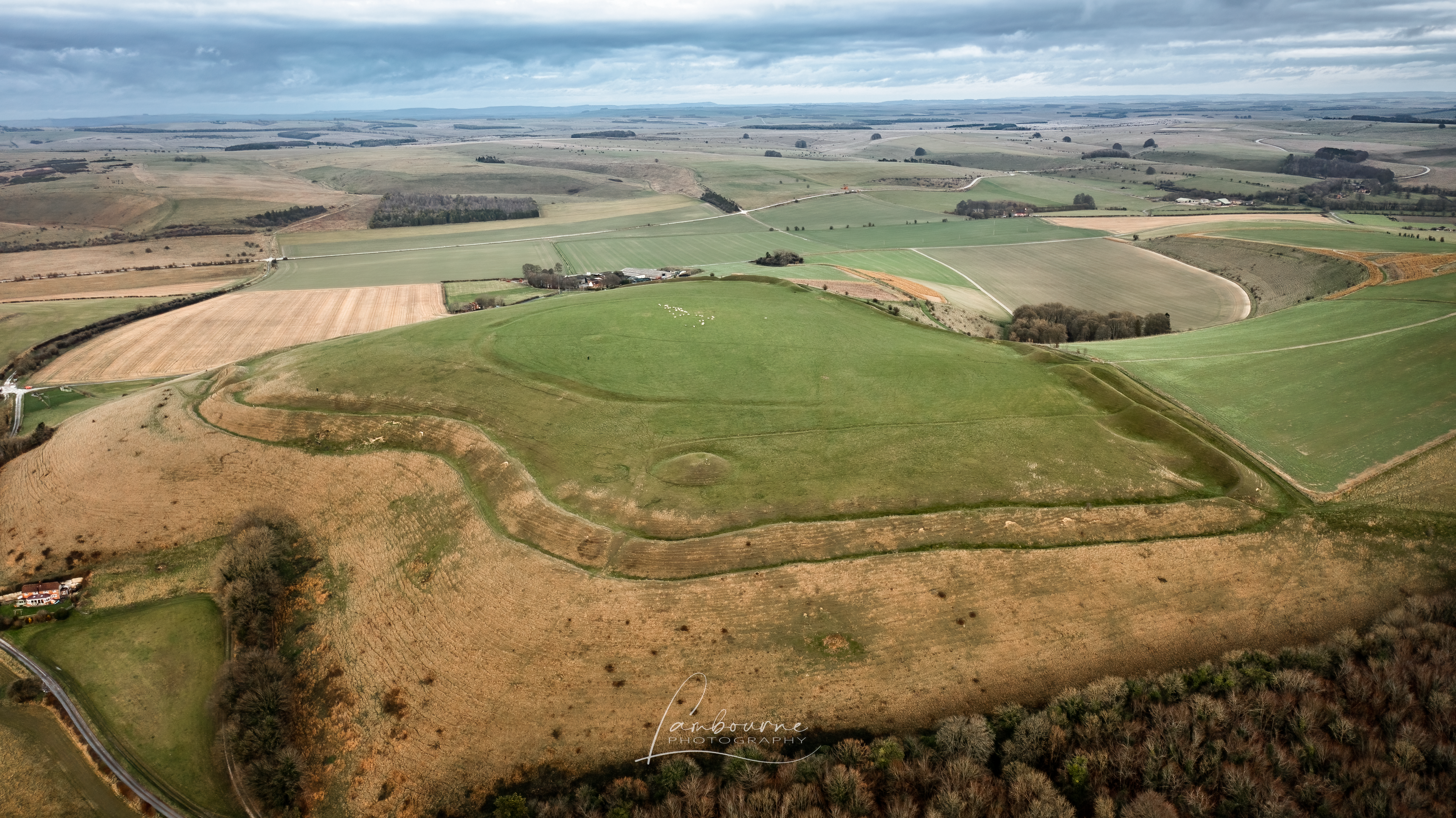
> **[Scratchbury Camp](https://dronescene.co.uk/where-to-fly-drone/scratchbury-camp/south-west/1594)**
>
> This location has been recommended to fly your drone in the Iconic Landscapes and Ancient Sites category in the South West region.
Land owner permission not required.
TOAL from the top of the hill, about a 20 minute walk up the hill from the car park.
> **[Scratchbury Camp](https://en.wikipedia.org/wiki/Scratchbury_Camp)**
>
> Scratchbury Camp is the site of an Iron Age univallate hillfort on Scratchbury Hill, overlooking the Wylye valley about 1km northeast of the village of Norton Bavant in Wiltshire, England. The fort covers an area of 37 acres (15 ha) and occupies the summit of the hill on the edge of Salisbury Plain, with its four-sided shape largely following the natural contours of the hill.
> The Iron Age hillfort dates to around 100 BC, but contains the remains of an earlier and smaller D-shaped enclosure or...
_The originator declared that this location was **not** inside a Flight Restriction Zone at the time of being flown on 28/12/2021. It remains the responsibility of any pilot to check for any changes before flying at the same location._
---
### Author:  [@JCUK66](https://greyarro.ws/u/JCUK66)
#### Post date: [13 June 2022 17:13 UTC](https://greyarro.ws/t/scratchbury-camp-added-to-iconic-landscapes-and-ancient-sites-in-south-west/40686/2 "2022-06-13T17:13:44Z")
Maybe I dont understand as Im new to drone flying, but when I look at this location on the where to fly map its slap bang in a red military zone! All other apps/maps etc I check mark it as a no fly zone too.even the dji map
> **[Geo Zone Map - Fly Safe - DJI](https://www.dji.com/uk/flysafe/geo-map)**
>
> DJI technology empowers us to see the future of possible. Learn about our consumer drones like DJI Mavic 3, DJI Air 2S, DJI FPV. Handheld products like DJI OM 5 and DJI Pocket 2 capture smooth photo and video. Our Ronin camera stabilizers and Inspire...
Am I missing something?
---
### Author:  [@milkmanchris](https://greyarro.ws/u/milkmanchris)
#### Post date: [13 June 2022 17:16 UTC](https://greyarro.ws/t/scratchbury-camp-added-to-iconic-landscapes-and-ancient-sites-in-south-west/40686/3 "2022-06-13T17:16:25Z")
> [@JCUK66](#):
>
> All other apps/maps etc I check mark it as a no fly zone too.even the dji map
Might want a read of this, dont be confusing NFZ with FRZ
> [@Can you fly? DJI NFZs v UK FRZs and other Air Space](https://greyarro.ws/t/can-you-fly-dji-nfzs-v-uk-frzs-and-other-air-space/10395):
>
> Went to my brothers Nr. Doncaster, Has good area to fly and its surrounded by farm land, so i took the M2P!! Before i got Mavic out of car i fired up drone assist, it was a high risk area, so I decided to leave mavic in car! My question is, could I have flown in a “High Risk” area? its about a mile or so from Robinhood Airport! can just see on horizon!
---
### Author:  [@LordParker](https://greyarro.ws/u/LordParker)
#### Post date: [13 June 2022 17:17 UTC](https://greyarro.ws/t/scratchbury-camp-added-to-iconic-landscapes-and-ancient-sites-in-south-west/40686/4 "2022-06-13T17:17:03Z")
It is in a danger zone and shouldnt be flown over, however you can pick it up from the road just past the turning for Norton Bavant
---
### Author:  [@clinkadink](https://greyarro.ws/u/clinkadink)
#### Post date: [13 June 2022 17:19 UTC](https://greyarro.ws/t/scratchbury-camp-added-to-iconic-landscapes-and-ancient-sites-in-south-west/40686/5 "2022-06-13T17:19:02Z")
> [@JCUK66](#):
>
> Am I missing something?
DJI Geo Zone = don’t prohibit flight, but do trigger warnings that inform users of potential risks.
Red zone = your drone _may be_ hazardous or prohibited.
Flight Restriction Zone = don’t fly … period.
---
### Author:  [@JCUK66](https://greyarro.ws/u/JCUK66)
#### Post date: [13 June 2022 17:19 UTC](https://greyarro.ws/t/scratchbury-camp-added-to-iconic-landscapes-and-ancient-sites-in-south-west/40686/6 "2022-06-13T17:19:04Z")
Ok, thanks!
---
### Author:  [@JCUK66](https://greyarro.ws/u/JCUK66)
#### Post date: [13 June 2022 17:21 UTC](https://greyarro.ws/t/scratchbury-camp-added-to-iconic-landscapes-and-ancient-sites-in-south-west/40686/7 "2022-06-13T17:21:51Z")
That’s good to know as I live right on the edge of salisbury plain under the Westbury White horse. Though I wouldnt fly directly there as a lot of paragliders. I bought it really for upcoming camp trips to Dartmoor, Cornwall and Scotland. But I wanted to try and get some experience locally first.
---
### Author:  [@clinkadink](https://greyarro.ws/u/clinkadink)
#### Post date: [13 June 2022 17:24 UTC](https://greyarro.ws/t/scratchbury-camp-added-to-iconic-landscapes-and-ancient-sites-in-south-west/40686/8 "2022-06-13T17:24:22Z")
> [@JCUK66](#):
>
> Westbury White horse
There’s a NOTAM in place for this evening, but normally OK to fly.
**Altitude**
This piece of airspace is in effect between Surface and 2900ft MSL
**Navigation Warning**
This is a temporary Navigation Warning, it indicates a possible hazard to aerial traffic in the region indicated.
**Active Now**
Active: Monday, June 13, 2022 6:20:00 AM until Monday, June 13, 2022 9:00:00 PM (UTC).
> **[Bratton Camp & White Horse](https://dronescene.co.uk/where-to-fly-drone/bratton-camp-white-horse/south-west/1593)**
>
> This location has been recommended to fly your drone in the Iconic Landscapes and Ancient Sites category in the South West region.
---
### Author:  [@LordParker](https://greyarro.ws/u/LordParker)
#### Post date: [13 June 2022 18:31 UTC](https://greyarro.ws/t/scratchbury-camp-added-to-iconic-landscapes-and-ancient-sites-in-south-west/40686/9 "2022-06-13T18:31:14Z")
cley hill, Dilto Marsh might be good. Trowvegas