Yes, Drone Scene previously used data from Altitude Angel, but this relationship has recently changed
. In October 2025, Altitude Angel, which also powered the official UK Drone Assist app, went into administration. Is this why it lags
Yes, Drone Scene previously used data from Altitude Angel, but this relationship has recently changed
. In October 2025, Altitude Angel, which also powered the official UK Drone Assist app, went into administration. Is this why it lags
As my old hillwalking buddy Tommy used to say, the ground is dynamic but the map is static. It is impossible for any map, even in tha age of computers and the internet, to be 100% accurate all the time because it cannot be updated in real time. So all maps or other representations of what is happening ‘on the ground’ (and up to 400’ above it for our purposes) are a compromise; some are clearly better than othrrs depending on the reliability of their sources and the alacrity with which they are updated. Drone Scene is probably as good as it gets in the UK, and I don’t know of a better resource!
Drone scene is the only one I use, hope it’s not affected by the collapse of Altitude Angel.
Apparently it uses other sources than aa, so it should be ok! Touch wood (stop that, Johnster, you’ll go blind/can I do it til I’m just short-sighted?)!
As posted above
So i am happy not to fly in any red areas, but can i ignore pale yellow AIAA, as just advice to be cautious? I wanted to take my drone on holiday to Scarborough coast next year.
@Returntohome I have moved your post here, Drone Assist have gone into administration so you wont get any support from them, which would have been our usual answer on how to read their map.
Our own DroneScene map is the best , and only resource that a drone pilot in the UK needs, fully supported by the community here ;o)
Could you please confirm that the key information shown on DroneScene.co.uk, listed below is, not sourced from Altitude Angel’s data?
I understand that things like National Trust land, Crown foreshore, and similar datasets are drawn from other sources (and of course, Grey Arrows flying sites are internal). However, those aren’t the critical elements here. Getting told off by a National Trust warden is one thing, inadvertently entering an RA(T) for a presidential state visit, because I wasn’t aware of it, is rather more problematic!
Are you signed up to the CAA Skywise?
Hi @JWflies, it looks as though you’re quite new here ![]()
Why not nip over to the Introductions page, and say hello properly and tell us a bit about yourself. ![]()
Hi @milkmanchris,
Thanks for getting back to me.
I’m JW. I am a hobbyist drone flyer and currently use a DJI Mini 4 Pro — it’s an absolutely brilliant little aircraft, and I continue to be impressed by what DJI manages to pack into such a diddy drone.
I had some fantastic flights last week during those calm, crisp days, but now it feels like I’d be blown halfway across the county if I even tried to take off!
Although I only fly recreationally at the moment, I try to approach everything with a professional mindset. That’s why I’m keen to double-check the source of the data: can you confirm whether the NOTAM, TDA, RA(T), Danger Area and Restricted Area information shown in DroneScene is sourced from Altitude Angel? Given that Altitude Angel is no longer operating, it’s important we know that the data isn’t coming from them.
Grey Arrows Drone Club has been working closely with the administrators of Altitude Angel since 7th October 2025, and we remain in regular contact with them.
To date, we have seen no indication that any Altitude Angel data used by Drone Scene has been impacted or has become inaccurate in any way.
Drone Scene uses a hybrid approach when generating its map layers, drawing on data from multiple different sources and combining them into our own bespoke layer types (see the About page for further details).
For the items in your bullet point list, our primary source is data supplied directly by National Air Traffic Services (NATS).
Because Drone Scene is dynamic, the source of a particular dataset may change several times during the day as updated information becomes available. Our hybrid approach is designed to ensure accuracy and timeliness, so on occasion data from multiple trusted sources, including Altitude Angel, is merged when this provides clearer or more current insight for our members.
If you notice anything that appears inconsistent or incorrect, please let us know by emailing info@greyarro.ws
Great stuff! Thanks for that.
Looking at DroneScene.co.uk I can see that the NOTAM, RA(T)s, Danger Areas, etc is being pulled in from altitudeangel.com - and I can’t see any connections to NATS. How does that part work?
I’ll keep an eye out for inaccuracies and let you know. I’ve seen a couple of issues, I’ll note them down and report back.
Thanks again for getting back to me. It’s really good to have your support on this. I appreciate it. Happy to be part of Grey Arrows.
The URLs you have highlighted in your screenshot point to external icons and images used by Altitude Angel. They are not URLs for a particular data source.
You will not see any direct connections to any external data sources (other than our own), for the reason already explained:
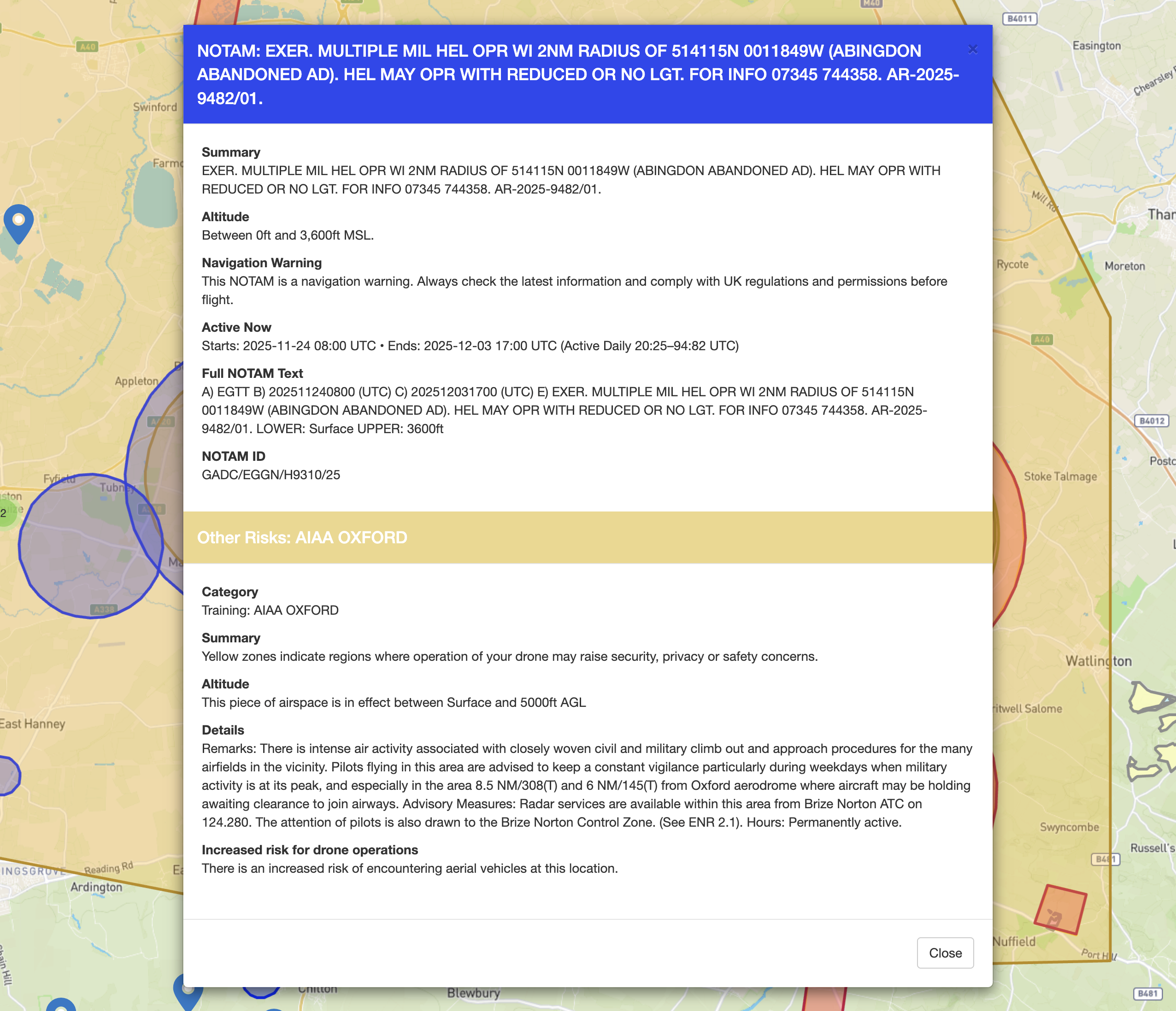
NOTAMs, at this minute, are coming from NATS.
This is identifiable by the GADC prefix in our NOTAM ID:
As explained earlier, this can, does, and will change at different points in time due to:
This is not cause for concern.
Drone Scene has operated on this model for more than seven years.
And to reiterate our earlier reassurances:
If we could keep this discussion thread focused on Altitude Angel and their administration process, please. If you have any other questions about Drone Scene please contact info@greyarro.ws
The Administrator’s Proposals have been uploaded to the Companies House details for Altitude Angel..
https://find-and-update.company-information.service.gov.uk/company/09350032/filing-history
According to the proposals they have agreed a sale with a third party, however the sale process has become protracted.
@Committee - stop protracting and just buy them already ![]()
![]()
![]()
![]()
If I’m not mistaken, AA looked like a parasitic organization who were trying to get in the middle and make money for flying when there was no charge. They were trying to become an “airspace manager” by the backdoor, and trying to introduce a pay-to-fly model. I don’t care how useful their app was - I do not support this kind of behavior. The data is available for free, even if not convenient. Someone would do better to find the data and at least show where it can be accessed instead of saying how happy they are to pay a 3rd party to do it for them.
Altitude Angel no longer exists in name… A change of name resolution has been filed and the business is now called AA Realisations Limited. Everything still appears to remain in administration.
![]()