This seems bad. How long can DA operate? I am unfamiliar with how things work behind the scenes.
4 Likes
Not great given its the only app based (as opposed to web based) i know of and is the huge majority data source for UK drone fliers.
Their main business is not providing FRZ lists to users though, its trying to embed itself with commercial drone services, make money from permission requests etc.
They’re the primary app in a few countries as well (Netherlands from memory too).
My guess is worse case the app will be sold off, turned into ad-ware/pay-per-use to one of the predatory developer/hedge companies that do that sort of thing.
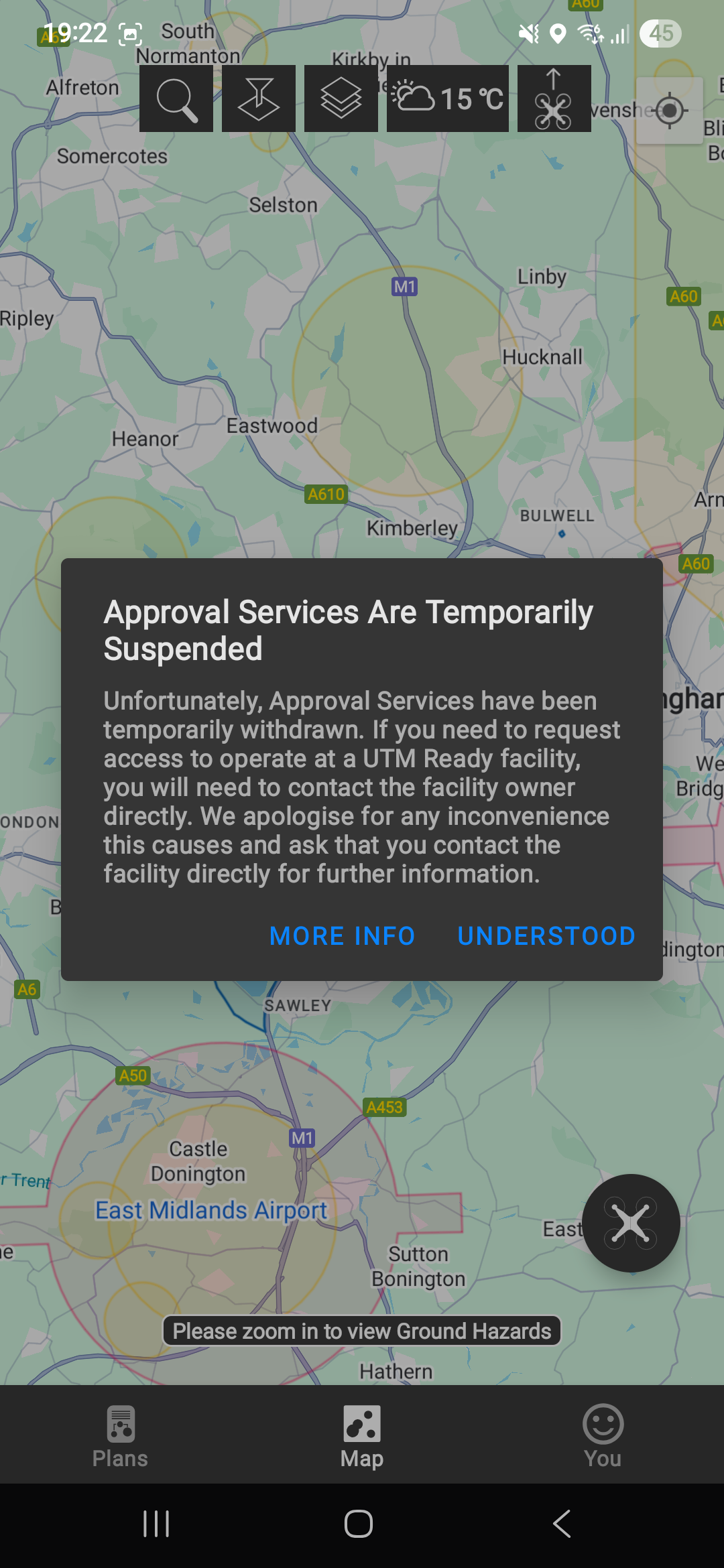
Edit:- Just fired up the app and theres a popup saying UTM facility requests are temporarily suspended which is irritating for those that use them. The “More info” link just goes to the single paragraph administration link as per above.
2 Likes
I’d happily pay a small annual sub (slight increase in op id) to merge the op ID with this function, so flyers get the tools and the legality for one fee
3 Likes
I got a similar message about the requests on DA
Posting notifications seems to still be working, i did a bunch today.
1 Like
Time for dronescene to take the bankloan and step up? ![]()
6 Likes
nsf.nats.aero is accessible again for those airports that used it.
1 Like
Access to an accurate source of data should be free, by all means pay for it from the operator ID fees, I’m sure there is money in that pot without hiking the fee.Charging for the info is like having to pay for an app to tell you the speed limit on the road you are driving down or the colour of the traffic light in front of you.
2 Likes
In an ideal world you are right.. BUT in the real world the maps need to be stored somewhere, network connections paid for and servers to run the thing kept.. running. Not to mention the effort required to keep it all up to date and checked. Adding a small fee to the hundreds of thousands of drone pilots, needing an operator ID to pay for all the above is not exactly ripping people off, as knowing where we are allowed to fly is critical for safe drone operation.
5 Likes
Technically it is free - the text data feed from NATs (which Altitude Angel and i think Drone Scene parsed). But unless you want to get a map, pen or other and manually plot its impractical.
1 Like
Watching this with saddened interest, but will this affect Dronescene? I assume not and it is possible the now current use will remain for some time with AA/DA just without the paying services for some time.
1 Like
![]()
1 Like
Drone Scene draws on multiple trusted data sources, including datasets we manually source and manage ourselves.
Because Drone Scene is built and run entirely in-house by Grey Arrows Drone Club, and we own and manage the whole end-to-end solution, we can respond quickly to any changes and ensure continuity for you, our members.
Only a limited amount of our data comes from Altitude Angel. We are in contact with their administrators, FRP Advisory, to assess any potential impact on our platform.
Thank you for your ongoing support — Drone Scene will continue to be an invaluable resource for the drone community.
27 Likes
Looking at the Companies House entries, they have a number of outstanding registration of charges. Ohh dear!
2 Likes
I do hope someone saves them. It’s an app I use all the time and an essential part of the toolkit. I would happily subscribe for a sensible fee. I think they should have charged all along for such a great tool and that may have been their downfall, substantial popularity will put a strain on the resources needed to run the service.
3 Likes
Advice from CAA:
3 Likes
Same here. I would like for the CAA to adopt the application at the very least - the portability of the data made it very valuable. I think the app should remain free - though I’d happily kick a couple quid into the ring every month to allow some “advanced” features.
2 Likes
Like many people you are talking about paying for AA if required.
But GADC members get Drone Scene with similar features to AA and more besides as part of their membership. Add the icon to your home screen and it’s portable.
Why do people prefer AA?
4 Likes
Oh I appreciate I have DroneScene to fall back on. The main things for me are UX, with some functionality issues.
On the UX, if I click on layered boundaries, I only see the topmost boundary info - nothing below. I have to toggles layers which is a headache.
Every time I move the map, all of the elements have to refresh. Out in the field this is a PITA when you have poor signal. DA seems to cache the map & overlay data to use when I’m off-line - so long as I dont quit the app.
Full screen mode sometimes doesn’t let me exit (likely a me issue).
Seeing the upcoming weather was a nice gucci feature.
I also regularly use the flight-planning tools in the app to alert of folks of my presense when completing commercial work.
Last thing on my mind, why does the Doncaster CTR still show when it was recently removed? Just bugs me and has me wondering if any other data is missing/out of date?
2 Likes
Fixed ( a while back I believe) Drill down info is certainly in the current version (v 40)
Flight reports can be posted from Drone Scene too..
See weather forecast is a nice feature. I was playing with Drone Cloud this morning and that feature is availble in the flight planning area. I was slightly surprised to see that the area I intend to fly on Sunday has winds of 23.7 m/s which is a touch too mich. Especially as other weather apps - Met Office, OKtoFly, Ventussky and Meteoblue are all indicating between 5 to 7 m/s for the same area, same time ![]()
1 Like