Is there a recognised way of calculating a building height from an aerial photograph? I am hoping to be able to measure the top height of a new build occurring near to where I fly. If I were to fly at a set horizontal distance from the building, and then take the drone up to say 15mtrs from ground level and take a picture, if the top of the build is “level” with the camera, would it be a fair shout to say that the build height is at the height of the drone altitude reading? Any input gratefully received. I can’t do a close TOAL, as the building perimeter is fenced off and I don’t want to risk an unsighted landing and take-off close to the building works.
I don’t think this is ever going to be precise enough to give more than a very rough estimate.
You’d be better off throwing a rock off and timing it!
![]()
![]()
![]()
If the building ground slab is at the same altitude as your TOAL, I would say ‘yes’ … +/- 1m.
Measure tool on iPhone is pretty accurate if yiu can walk up to the place
Get the Arboreal app from the App Store if you can get near to the subject and have room to walk away from it. I have used it for a tree calculation was necessary due to a wooden fence. It’s spot on, The falling of the tree missed the fence by a few inches like I knew it would.
1 Like
Depending of the age of the building, you should be able to find all required details in the planning application that was submitted to the council. Of course, it won’t be as much fun to do!
Laser tape measure if you had one , would that do it ![]() just a thought.
just a thought.
What drone do you have? I tried to measure all sorts with my mini 2. I even tried borrowing some fancy survey GPS equipment and still couldn’t get it an accurate height as the mini 2 uses atmospheric pressure in a combination of other things.
So not very accurate I’m afraid for any of the non rtk drones.
Can you see the bottom of the building / the ground from your intended TOAL point?
If so, take off from anywhere, fly over to where the building is, line yourself up with the top of it, make a note of the altitude in your app, drop straight down as low as you dare (to say 1m off the floor), note the new altitude, subtract from the previously noted alt, job done? ![]()
Anything scalable in the photo ?
Car/person/skip ?
Your local online planning portal will have the plans, thats how I spy on Karen and Ken ;o)
1 Like
Could have used it to find an angle of sight to top of the building. Use the drone to measure the distance to the clinometer and use trig to get the height ie X=tan Theta/length.

2 Likes
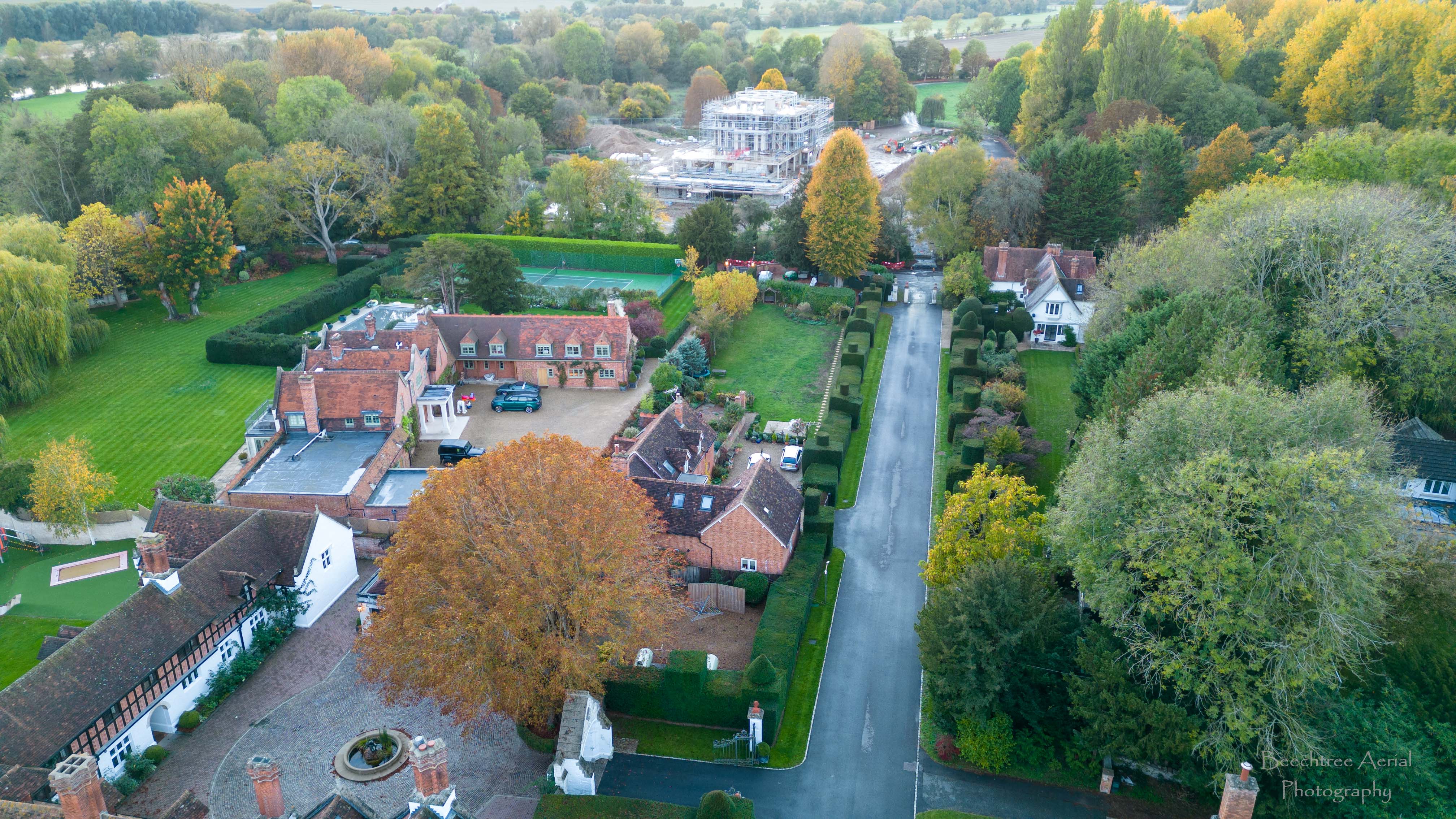
Guys, I value all of your comments, thank you for your input. I have suggested to the people involved it would be a whole lot simpler if they approached the site manager and just asked to have a look at the plans. You can see from the image included just what they are concerned about. The dwelling being erected is slated to be 16mtrs top height once the “dome” is installed. Once it is topped off it is going to be a very dominant sight to look out onto.
My planning software gives an idea of the building heights of completed buildings.
I assume you mean the building in the background.
Look on the local authority portal for the plans.
Reach out to me at planninggeek.co.uk if you need help finding the plans etc.
1 Like
The local planning authority will hold the info you need and yu will be able to access it online for free.
Rough guide if you can see how many storys it is take a calculation of 3 to 4 metres per story.
That should give you a guide.
The local planning office has the building listed to be 14.2 metres to the top of the (yet to be fitted dome). A few of the local residents were anxious to know whether it would come in at the correct height and how could they check what was actually being erected, hence where this conversation grew from.
Any golfers in the village, a range finder would tell you
I’m sure there would be quite a few golfers living nearby, it’s quite a select area ![]()
1 Like
…thys height thing on a drone. How is it done when the barometric pressure setting is not set each flight using the pressure reading if the area…? or are they using the standard 1013.2 setting as a norm?