Can I fly at Hooe Lake?

I want to go to Hooe Lake tomorrow but it is in a large red “Danger” zone.

The description says it “Red zones are regulated high-risk areas and operation of your drone may be hazardous or prohibited.”

Then at the bottom " Intermittent Airspace" is listed.

DJI Fly has no warnings here at all.

As I am flying within the new rules, under 400ft, vlos, Mini 2 etc, etc. Can I fly here? Where do I ask to find out?

Thanks,

Google maps: 50°21’25.3"N 4°06’18.9"W - Google Maps

1 Like

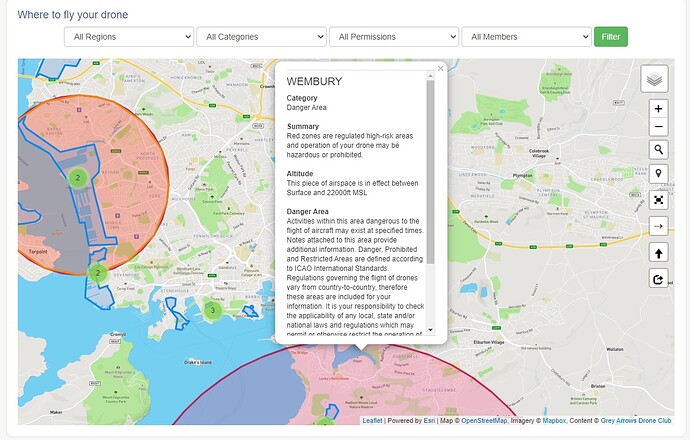
If you zoom out you will see that the danger area is an irregular shape mainly out to sea. Scrolling the description gives:

WEMBURY

Category
Danger Area

Summary
Red zones are regulated high-risk areas and operation of your drone may be hazardous or prohibited.

Altitude
This piece of airspace is in effect between Surface and 22000ft MSL

Danger Area
Activities within this area dangerous to the flight of aircraft may exist at specified times. Notes attached to this area provide additional information. Danger, Prohibited and Restricted Areas are defined according to ICAO International Standards. Regulations governing the flight of drones vary from country-to-country, therefore these areas are included for your information. It is your responsibility to check the applicability of any local, state and/or national laws and regulations which may permit or otherwise restrict the operation of your drone in this area. Unless regulations in your region explicitly permit the operation of your drone in this area, we recommend you do not operate your drone here.

Intermittent Airspace
Intermittent airspace are volumes that are temporarily activated, typically via a NOTAM or pre-defined schedule. (My Italics)

So it seems to be an area used by Grey Funnel Lines, operating out of Plymouth, to exercise their gunnery skills. A Notice to Airmen (NOTAM) will advise when the range, or a sector of it, is in use. The great thing about the Dronescene map is that it is fed with live data - when a NOTAM is announced and when it is in force the area affected is coloured in blue.

So you cam male your plans, check before you go and, if no blue areas where you intend to fly, go and have fun!

Further east you will see a similar pattern and warning either side of Portland - Lulworth Ranges.

And an example of a NOTAM local to me, the local cloudpunchers (Royal Artillery) will be playing shoot the drone down at Baker Barracks, Thorney Island:

UAS OPR EXTENDED VISUAL LINE OF SIGHT

Category
Navigation Warning

Summary
Blue zones are advanced notice of areas that will shortly become either red or yellow, while yellow regions with a blue border are notice of a current drone flight.

Altitude
This piece of airspace is in effect between Surface and 1010ft MSL

Navigation Warning
This is a temporary Navigation Warning, it indicates a possible hazard to aerial traffic in the region indicated.

Active in 16 hours, 36 minutes
Active: Monday, February 22, 2021 8:00:00 AM until Friday, February 26, 2021 5:00:00 PM (UTC).

Full NOTAM Text
Q) EGTT/QWULW/IV/BO/W/000/011/5049N00055W002 A) EGTT B) FROM: 21/02/22 08:00 C) TO: 21/02/26 17:00 E) UAS OPR EXTENDED VISUAL LINE OF SIGHT WI 1NM RADIUS OF 504843N 0005516W (THORNEY ISLAND AD). MAX HGT 1000FT AGL. FOR INFO 07522 791020. 2021-02-0353/AS2 LOWER: SFC UPPER: 1010FT AMSL SCHEDULE: 0800-1700

NOTAM ID
EGGN/H0443/21
2 Likes

Thanks for the reply, That it what I was hoping for.

An area to keep a close eye on and be careful…

1 Like

@Mike_P I went on Plymouth Hoe couple of months ago about 7pm when it was dark, now on the NoFlyDrone map there was no restriction in that area, but Dji app come up with a warning in that area before I started flying , so I cancelled the warning and flew for 10 mins then went home…

The Hoe was deserted, no one around… but Wembury area and Staddiscombe are under a no fly zone.

Mount Batten pier is not.

I use No fly drones

You may as well have asked my neighbours cat for advice :rofl:

2 Likes

Be careful as that site does not show live data including NOTAM’s.

1 Like

I cleared it with the neighbours cat first…

1 Like

:rofl:

What is the best data map to use then , me and neighbours cat are confused…

Not one that allows any random member of the public to invent and submit a no-fly-zone of their own :blush:

2 Likes

Login to see all the good stuff.

3 Likes

I plan on going up the Hoe one day soon too.

I was asking about Hooe Lake which is in that Red zone.

It does look like a cautionary area rather than a No-Fly Zone unless it has other warnings at the time of the flight.

1 Like

Wembury as attached…

http://www.flysynergy.com/wp-content/uploads/2014/01/Plymouth-Military-Radar.pdf

PLEASE DON’T!

It is a site full of misinformation and downright lies. ANYONE with a grievance can contact the site owner/admin and request that their favourite piece of land is made an NFZ.

That is why, apparently, the entire seafront of my island is a no-fly zone - irrespective of whether it is council-owned, privately held, common land, over water or Crown Estates. Even my own house is marked as being in this spurious NFZ that appears on no other official or unofficial app.

The only resource that you need to use to determine where to fly is Dronescene which displays real-time information from a variety of trusted official sources.

Even if it wasn’t developed and maintained by a small group of very clever GADC members I would still recommend it as the best resource available = just click on the three bars at the to[ right hand of any page, next to your avatar, for the link to Dronescene and also the Good 2 Go app that determines where you can fly what drone with a variety of qualifications - or none at all.

4 Likes

@macspite Thank you , I will take your advice and delete No fly drone and use the Dronescene…

2 Likes

Let us know what you think, we love the feedback and do act on feature requests :wink:

2 Likes

Well I have just logged into Dronescene and it is a lot more information and it has great explanations when you click on a coloured zone… Can I get this on a app for my android phone…

The more I look the more I am astonished of its information it is providing, I will use this from now on…

Thank you

Just save the site as a shortcut on your Home Screen, it has a nice icon.

It will act just like an app.

1 Like

If you then look up the restriction numbers here : eAIS Package United Kingdom

The restrictions only apply Monday - Friday and when activated by NOTAM. I have looked at this before as live locally.

For some reason people seem reluctant to give up using multiple sources and use Dronescene instead.

Dronescene uses live data from CAA, Altitude Angel, Crown Estates, National Trust and others displayed as switchable layers over a choice of map styles. NOTAMS and flights notified to the CAA are displayed for their duration. It also has flight sites used and proven by GADC members with accompanying details. The number of places checked out is constantly growing.

Why the reluctance? Is it because it is FREE so is perceived as having no value. Try it! Add the icon to your home screen and check out your local area. You won’t regret it!

3 Likes