Merged recent posts re Stevenage, and a previous thread about DJI NFZ v UK Restrictions, into an even earlier post - rather than have too many duplicated posts about the same topic, and to provide additional thoughts and information on this potential for confusion.
Good evening all
Could anyone please
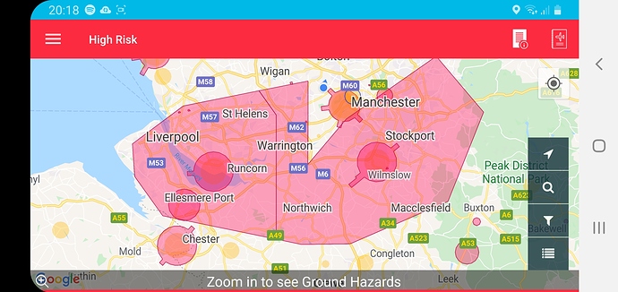
Nats Drone Assist obviously says no to the red zones around the airports and runways but does that include all the large ‘pink’ areas?
I wondered if we were to see a cross section through the whole area would it be ‘T’ shaped with the pink areas maybe being a higher altitude NFZ?
Or am I talking out of my arse and unfortunately we can’t fly in the whole pink area without traffic control permission?
It takes a whole load of great flying opportunities out of my grasp that are local to me if it’s a no no.
On another note that’s intrigued me, does anyone know what the laser display is in Eccles at 9pm tomorrow?
Cheers
Moved your post over to this thread that has discussed these issues before.
Tis is the map with Class D airspace removed:
Can you fly in Class D airspace?
" There are no separate regulations in place regarding the flight of small unmanned aircraft in controlled airspace below 400 ft (Class A,B,C,D,E). Restrictions involving the flight of UAS within Aerodrome Traffic Zones are described in Flight restrictions around aerodromes. UAS pilots are reminded of all other responsibilities, including the Air Navigation Order requirements, that any person in charge of a small UAS:
- may only fly the aircraft if reasonably satisfied that the flight can safely be made and;
- must maintain direct, unaided visual contact with the aircraft …for the purpose of avoiding collisions. Note: The use of normal corrective spectacles is acceptable within the term ‘unaided’
If operating above 400ft within controlled airspace, the permission to do so granted by the CAA will state that appropriate permission from the relevant Air Traffic Service Unit (ATSU) must also be obtained."
(From CAA publication)
Yes you can, subject to local restrictions, but stay vigilant.
Here is a zoomed in view of the class D airspace that surrounds LBA, the little yellow blob in the pink area is actually the site of my local model flying club.
Nidge
![]()
My map has just become a whole lot sweeter, many thanks chaps 

Hi,
I’ve been asked to do some filming (non comercial) for a friend of mine who lives near Gatwick Airport.
I checked the DJI Geo Map (Geo Zone Map - Fly Safe - DJI). My fiend lives in an ‘Altitude zone’. I understand that my MM will automatically have an altitude restriction imposed upon it.
And that’s fine… question is, does anyone know what that altitude figure is?
TIA,
Ned
Hello. After checking a few apps, Drone Assist, showed the information.
I flew on the north side of Crammond Island, near the approach path for EDI. The go4 app limited me to 60m which was perfectly adequate.
It was easy to see the planes, and I lowered the Mavic to about 20m, just to show a bit of respect!
Kind regards
Jerry
Moved your post over to this generic thread. The altitude restrictions are shown on the DJI site. Link in above post.
My first experience of a refusal to take off by my Mavic pro. Attempted purely as a test. The tech works.
Well - yes/no/maybe.
The map is UK data.
What stops your DJI drone flying is DJI data.
The two are neither the same nor do they even marry up.
But, as in your example, sometimes they do.
Moved your post to a thread that explains the differences mentioned by @Pterodactyl. 
Ah, I see. Ok, thanks I’ll check the original topic out.
DJI NFZ Auto-Landing
Does anyone know if this is still implemented in newer models like the Air 2? I’ve read several reports of drones coming down automatically with complete loss of control on entering a NFZ, and whilst I appreciate that we shouldn’t be flying near one, in the event that you did an automatic landing could be somewhat problematic!
Thanks all
Your post has been moved to this thread that covers NFZ/FRZ etc. since, even if this specific question hasn’t been asked/answered above, any replies will be more relevant here.

Also - it’s important to understand the differences between FRZ and DJI’s NFZs - which is covered above.
Can’t see why they would have stopped implementing this. You get plenty of warnings before you get to one.
Check before you fly, simple
DroneScene is your friend.
I appreciate the responses, but they don’t really answer the question. Q: “What happens when an airbag deploys?” A: “Don’t crash!”. 
As I said, I appreciate that we shouldn’t be flying near one, be that a DJI NFZ or a FRZ, but in the event that we did fly into one would a DJI craft automatically land irrespective the terrain below?
Only experience I have (and a fun one at that) was a local geofence where I used to be able to bounce a friends MP off the invisible ‘wall’
I never have that issue on my .700 MP ;o)


