This local reporting provides police perspective and quotes on the UK’s experiment with “drones as first responders” in Coventry, which has been trialing this for a while now. (Google Coventry DFR to find more on this.)
The impact on amateur drone enthusiasts like me is not covered in the article and I am thinking of talking to the reporter about this topic. But first I would like to get a sense of how other folks feel about this subject.
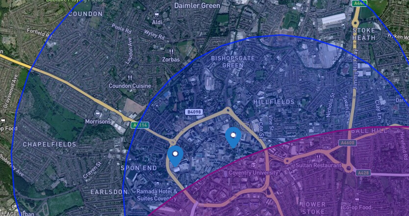
For example, the police drone project has created an ongoing series of NOTAMs that appear to have made the centre of Coventry, my home town, a no-go area for months now. Below this message I have pasted the current NOTAM, which keeps getting renewed.
However, I am not a NOTAM expert (yet). To educate myself, I plan to ask the CAA if I can use my DJI Neo 2 in a local park that falls within the radius of restriction and will report back how that goes.
Interested to hear what others think, especially in other locations where the Drone First Reponder programme is being trialed. Aside from my tiny personal interest, there are lots of big picture issues raised by the DFR programme, e.g. how will this integrate with planned commercial use of drones for deliveries?
With apologies if I missed discussions of this elsewhere on the forum.
TEMPO DANGER AREA (TDA) EGD298B INSTALLED WI 1.35NM RADIUS OF
522429N 0013037W (COVENTRY). BEYOND VISUAL LINE OF SIGHT UAS OPS
CONTAINED WHOLLY WI THE TDA. MAX HGT 400FT AGL. EMERG SERVICES
ACFT MAY ENTER THE AIRSPACE IN ACCORDANCE WITH LOCAL
DECONFLICTION AGREEMENTS. FOR INFO CTC
AROPS(AT)CAA.CO.UK.AR-2025-9475/04.
LOWER: Surface, UPPER: 900 Feet AMSL
FROM: 01 Feb 2026 07:00 GMT TO: 28 Feb 2026 23:00 GMT
SCHEDULE: 0700-2300
This is the very reason TDA’s which are ridiculous in size are popping up across the country… It’s becoming a ball ache for many flyers who have to email the CAA who then approve it with the sponsor. Also a number of TDA’s are automatically renewing at the end of the month, Southampton is a classic example where a TDA has auto renewed since it was first introduced in December of last year.
looking on Drone Scene the area’s your on about are in blue - so its just a warning so not really a no fly zone for a drone - or have I got this wrong ?
I know not all Red areas are a no go for Drones - quite a few like this around London
The red area around Cov is the airport and that goes without saying
Ah every day a school day - not something I have ever really come across before - rarely do I fly near zones like this - only time I have seen blue zones are around cranes in Birmingham city.
I just emailed AROps @ caa.co.uk and will report back on response. Will try to answer:
A. is permission required for small private drones e.g. DJI Neo 2?
B. does permission request have to be specific as to date/time/location?
C. can we expect an end to the repeating NOTAMs used in places like Coventry and Southampton?
Well that was quick! Here is the initial response:
Good Morning,
EGD298 is sponsored by the local Police Force as part of the National Police Chiefs Council (NPCC) Drone as a First Responder (DFR) Program.
If you wish to request access please email AROps@caa.co.uk and provide the Location, Date/Time and your contact details and we will liaise with the Police accordingly.
The current NOTAM expires end of Feb (Friday) so I will wait to see if it renews. If it does, I will pick location/date/time in early March and report back on how that goes.
I’ld suggest that area for a meet, sone fairly interesting subjects to film but im not sure how that local sailing club would react to a bunch of arrows turning up
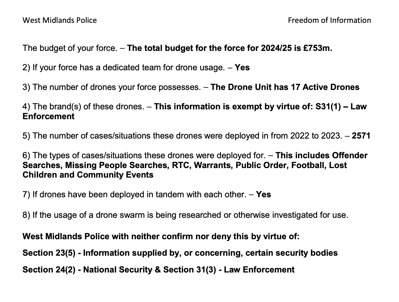
It would be great to find out how often the emergency services have actually launched drones over the period by per month, it could then be challenged at the CAA, if for example the operation of emergency drone is say less than 5 - 10 incidents per month.
Stick your own in, I find the police are usually very receptive, make sure you ask for a month by month breakdown though, make them work for their money