I visted Monsal Head in Derbeyshire a couple of weeks ago, for those who don’t know it, it’s a fabulous vantage point overlooking Monsal Dale and the viaduct carring the track bed of the former Mildland line. In addition to myself there were two others with their drones and a thought crossed my mind. If I went further out and did a RTH then I would have to factor in the additional depth below me in the RTH setting. I wondered if the altimeter was barometric does it use the optical sensors additionally for the near to the ground readings. Anyhow here’s a photo I took on the day.

4 Likes
DJI Drones use the TOAL point as their reference, so what appears on the screen is the height difference from where you took off - meaning you need to manually factor in the changes in terrain height…
This does mean that if you are flying up the side of a mountain you can exceed 400ft above the TOAL point, however, you must stay within 400ft of the ground…
And if flying over a valley then you will need to descend as the terrain descends to stay within 400ft of the ground below you…
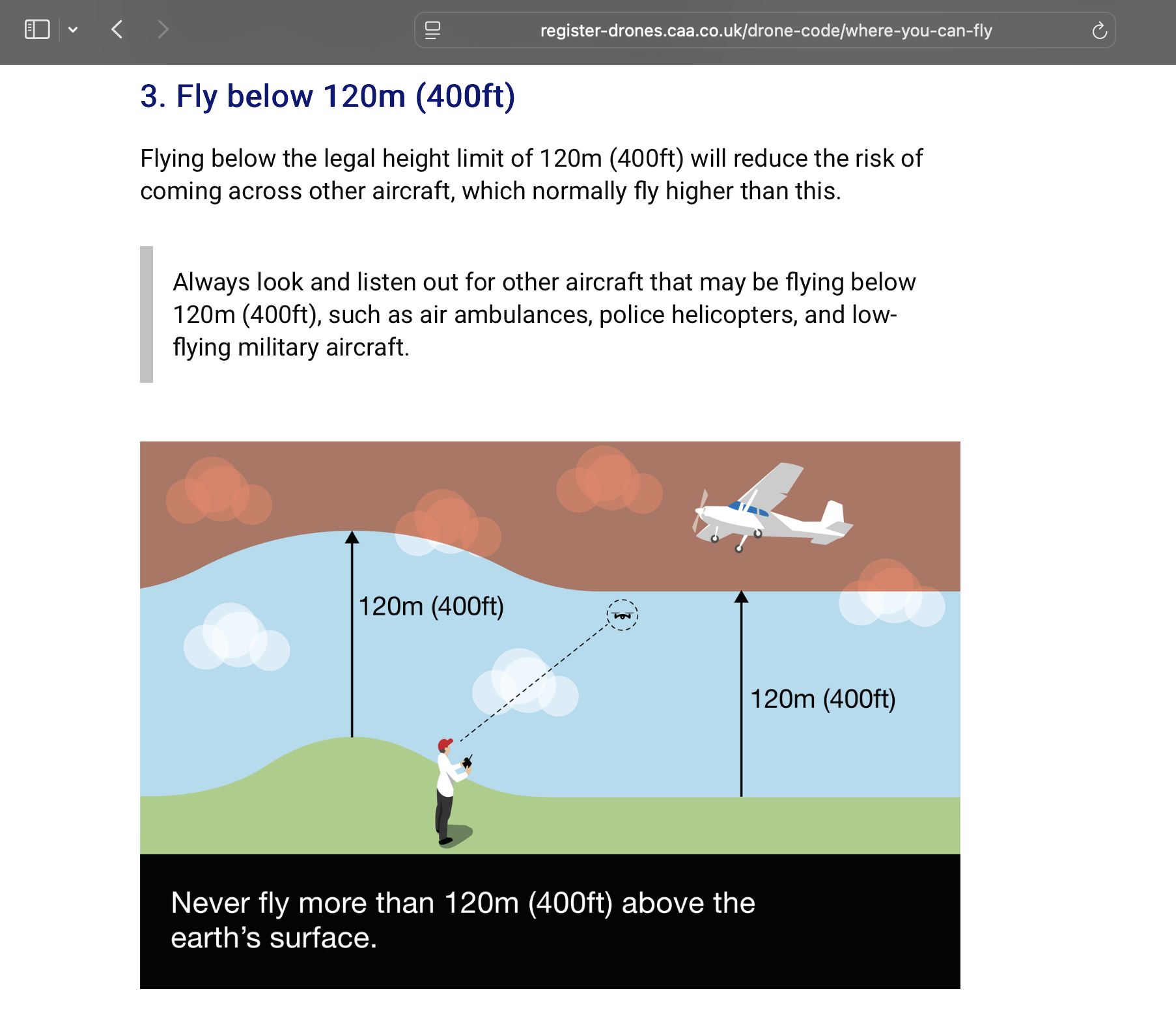
All covered in the CAA DRONE code -
3 Likes
Yes it’s a barometer
1 Like
Generally yes, they use Barometric pressure. But also some drones may also use GPS data depending manufacturer and software.
1 Like
Thanks Suzanne, I get all that, my real question is it barometric coupled to optical for near the ground. When I used to fly I would set in the barometric pressure on the altimeter to either read 0 (QNH) or the actual height (QFE) So DJI set to zero at the take off point but barometric alone cannot be accurate enough on it’s own when you’re relatively close to the ground. So my question is does it use a combination of optical? or whatever for the near to ground.
1 Like
Optical isn’t generally used for height. It does get used for secondry positioning. Ultrasonic sensnors are sometimes used for height measurement at low heights
1 Like
It must use a secondary sensor I’ll check it out with DJI thanks
The drone code actually states the nearest point on the earths surface, this may not necessarily be the ground below you. ![]()
1 Like

The downward vision sensor is not used above 10m only the barometer is used for height calculations
The accuracy is variable and is just for reference
3 Likes
Thanks I didn’t think the barometric alone would be good for near to ground readings
I am still puzzled by the altitude thing. I can’t find a DJI site saying my mini 4 pro has a barometer though these are as cheap as chips now. I like the CAA picture but if the drone is using gps for height (which has high error bars generally) and also measuring height above take off position can you…
- Fly up the side of a mountain maintaining 120m above ground level? Violates 120m above take off point but meets CAA rules
- Fly off a cliff greater than 200m high. Nominally drone would allow 200m cliff + 120m above take off point. Also it sees negative altitude from launch if you descend so is this ever an issue eg RTH. Would break CAA rule. Does drone descend to 120m never to be able to climb up to home point.
Advice appreciated from real experience!
This is correct for flights under EASA regulations, but under the CAA Regulations maximum allowed height is not stipulated from the Take off Point, but the nearest point on the earths surface (taken from a point directly underneath the drones position in flight). The diagram at the link in the regs provided by Suzanne above shows this clearly
“If you fly where the ground falls or rises, such as over hills, mountains or cliffs, you may need to adjust your flight path so that your drone or model aircraft is never more than 120m (400ft) from the closest point of the earth’s surface.”
Thanks. That was my understanding. I was wondering what rules the drone follows in terms of altitude in the above scenarios. Does it terrain follow? Does it aallow you to show actual altitude?
Only from takeoff point
It’s quite easy to get it in - numbers
Your explanation is correct if you delete the above 11 words. The CAA rules state from the closest point on the earths surface; this does not have to be directly underneath the drone.