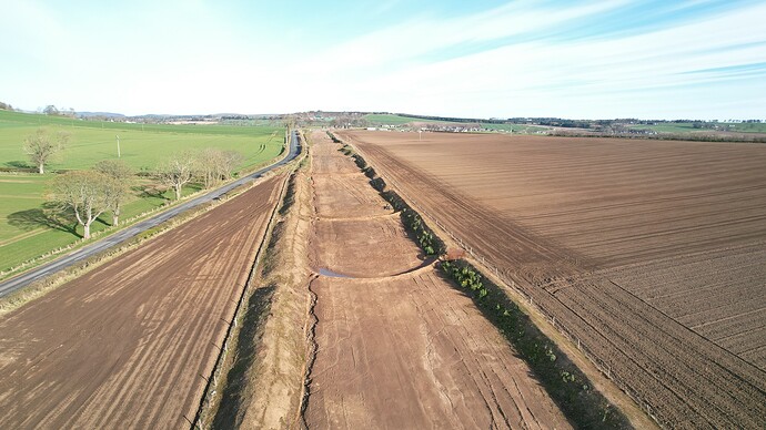
The stars finally aligned this morning and I was able to go fly my A2S again ![]()
It was cold and I had a limited amount of time to fly before I lost sensation in my fingers, but I needed to complete a couple of tasks. First was to just fly and practice, it had been a few weeks and I always approach these flights from the status of “rusty”. Next I wanted to extend my comfort zone with distance, I mentioned elsewhere recently that I struggle with confidence in flying too far away. I am going to be traveling with the A2S at the start of May and wanted to do something about this (OK, in baby steps).
My final task was to try out the Maven app for the first time on the A2S. I had to wait till the end of March for DJI to release the SDK so the Maven author could update the app to include both the A2S and the Mini 2 drones. I updated the software on my iPad Mini5 yesterday and watched as many tutorial videos as I could and then headed out to give it a try.
If anyone else is interested in learning more about how to use the Maven app I can recommend the “Waddle Aero” series (Mastering Maven for DJI Drones: Episode 1 - Waypoint Missions - YouTube).
I started with the practice sessions and combined that with a stretch of my range anxiety. Where I live a company called “Roadbridge” has been creating an 11 mile scar on the landscape over the past 2 years. This is for the “SeaGreen” Windfarm project. Unfortunately Roadbridge just went into receivership and the groundworks have been left abandoned for the entire 11 miles.
I was happy with this progress so landed the drone and switch on the Maven app.
I began with a very basic Waypoint pattern. I wanted the drone to fly to the start point and then follow the route to completion. Simple. I was not interested at this stage in POIs or camera direction etc. Just wanted to make sure it would do what I asked it to.
As you can see, I was not very ambitious.
One thing that struck me immediately was that this app is using Google Maps and its quite out of date. The red arrow signifies where the Seagreen Windfarm project scar is now present. That means I need to do a proper review of the area I am planning the route for and not rely on what I see on the app map.
I hit my first issue almost immediate. It was a newbie issue and just reinforces my need for much more practice with the app.
I had placed my first Waypoint out in the field on the far left-hand side and had expected the app to fly the drone to that location before starting the pre-programmed route. The drone lifted off and then reported an error and that it was cancelling the route. I landed the drone and thought about what had just happened.
As far as I can tell, Maven had not liked the starting height of the drone because it was in a fenced off area and had triggered an obstacle detection. This was my own fault, of course, I should have set the liftoff hover height to be something more significant.
Next try, I started by taking the drone up to 10m and then hit the “Fly Route” button (can’t remember what its actually called, but that get’s the gist of the action). Off it went and followed the preprogrammed route.
Several things became evident very quickly and speak to how much I have yet to learn about this app.
- The drone was absolutely crawling along (note to self: increase the speed between Waypoints.
I had a great example of this when the drone completed the route. I had set the final action to RTH and when this kicked in it fairly tore along until it landed back with me.
-
The camera was acting like it was the morning after a really heavy night of drinking. It was sort of pointing slightly to the side and generally not paying attention. (note to self: set a POI and have the camera follow that, or just tell it to look forward.
-
I need to have a plan for what I want Maven to DO when running a mission (but that’s on me again).
What I can tell you is that I really like this app, especially because the author, Michele Vagnetti is adding new features all the time and is listening to his audience.
Can’t wait to play with this some more ![]() .
.


