Nats shows the entirety of Skye as follow drone code but someone pointed out that half of Skye is restricted as it’s a LFA, Ive enquired about this and been given a spreadsheet to fill out with my planned flights which I’m assuming would have to be done daily, one day in advance…which is a ballache.
Is this actually necessary? Or is there some way around it that’s much easier than filling a spreadsheet out with your planned flights including Lat/Long
Sorry I wasn’t very clear, basically see the image you provided, that box with the white outline is the area I would be flying in and I contacted the low fly area team via the gov website to try clear this up and that was the response I got from them
A courtesy call to someone at the RAF to tell them what I was doing would be both advisable and courteous, but could then open your can of worms re paperwork and signoffs
Maybe some other members here have already flown around that way? They might be able to provide first hand advice. Tagging @ash2020 as he lives the nearest. Albeit 60km as the crow flies and 300km by road
Sorry, only just seen this. I’m afraid I can’t really add anything apart from to say that the huge area covering the Northern Highlands seems excessive. I’ve only ever flown at the very North of Skye which, from what you say isn’t a problem in the white zone. (I’ll refrain from the very tired Airplane joke!)
See I’ve not seen any of that stuff when I’ve been looking, thought that area on the west was fine to fly.
Question really is why on earth do the likes of nats etc all show follow drone code when it’s not accurate? So you think as long as there’s no NOTAM it will be fine?
As it stands I’ve been giving an Excel spreadsheet which requires date and time of flights, co ords and how many drones will be flying which have to be sent in advance, so it’s looking like my week at Skye will have to be completely planned if I want to drone, whereas I would have preferred a less structured trip.
Also do NOTAMS show up on databases such as NATS? sure I’ve seen them before
Now I’m just more confused haha, so is the general consensus that as long as a NOTAM isn’t activated there’s no need to report flights? Even in the box with the white outline in the image above?
I can’t find the number you’d call to enquire about flights
I think 95% of us would likely see there’s not a NOTAM and fly there, but keep in mind it is a restricted area so be a little extra vigilant. Personally, a call to them before flying wouldn’t go amiss and can’t do any harm.
To be fair to them, when you registered yourself as an operator you had to pass a test and the training for the test does include this:
And the recommended drone apps in the link they have (which includes dronescene) do include the restrictions. Yes, there are nuances that can make the restrictions less… restrictive. But unless you know where to find the details, general rule of thumb should be that if you check the app (as you should) and it says the airspace is restricted then assume you can’t fly until you are sure you can.
If you see a restricted/danger area, you can find the details online. If you click the white box over Skye the name of the area is given as ‘The Highlands’. Search for that here and you should find more information about the specifics, including the number to call.
A few fair points there Joe, I think for the most part I’ll stick to what I’ve been told and just register my flights, seems like the most sensible thing to do.
I emailed the low flying team (mod email off the gov website) and they passed me over to someone else, in her email signature she has a RAF email, a mod email and also a NATS email, I posted a screenshot of the email above in the thread.
SWK-LFOF-LFBC is the email username
I’ve checked the link and Highlands says it’s not permanently active and is done by NOTAM, so as you’ve said ‘should’ be fine to fly, do you think it would be worth calling ahead of my trip to speak to someone about this? I have a day off tomorrow so could call, if it’s not necessary to register flights and I can just ring for clearance that would be much better.
She attached an Excel document to fill out which looks like this
Ah, so you did - I see the screenshot now. (BTW - you’ve posted your personal email address in an unlocked part of the forum)
With the “as I understand it” caveat…
The military can use the whole of the UK airspace for low flying. In general, that’s down to 250ft for fixed-wing and helicopters down to 100ft (though they can be authorised down to surface level).
There are then three TTAs (Tactical Training Areas) where fixed-wing aircraft can be down as low as 100ft. One of those is a part of the Highlands Restricted Area, but not the bit that covers Skye. There’s some info here in the other discussion on the Highlands and you can find a timetable of when the TTAs are active here.
So, my take on this is
Part of Skye is covered by the Highlands Restricted Area (R610B) which is activated by NOTAM.
Skye is not covered by the Scotland TTA for low flying operations
Like the rest of the UK, it’s always possible you’ll get low-flying military aircraft over Skye (arguably more so as it’s fairly close to the TTA). Likewise, the coastguard/air ambulance/police chopper could buzz you wherever you are.
If I were doing a commercial flight on Skye I’d be filling in the spreadsheet in advance and calling them on the day.
But for ‘hobbyist’ flights (to my mind) the important thing is to check on dronescene (or whatever app you’re using) before every flight to be sure you aren’t in R610B whilst it’s activated, or if you are that you’re not up a hill and flying above the level where it starts. And keep your eyes extra-peeled for incursions. Belt & braces, does no harm to give the number they gave a quick call in the mornings to check if they expect any low flying over Skye that day?
As I say, that’s my take on this. Since you have the day off you could give them a call and check they don’t have a different view?
Thanks mate you’ve been a tonne of help and good spot on the email, I’ve deleted it I’m new to the forum as you can see haha.
Which number though? The one from the email, some sort of RAF number? The one in the email is for RAF Swanwick which is in Southampton, surely I’d want to be ringing Lossiemouth as that’s the closest to Skye, unless Swanwick is like a ‘head office’.
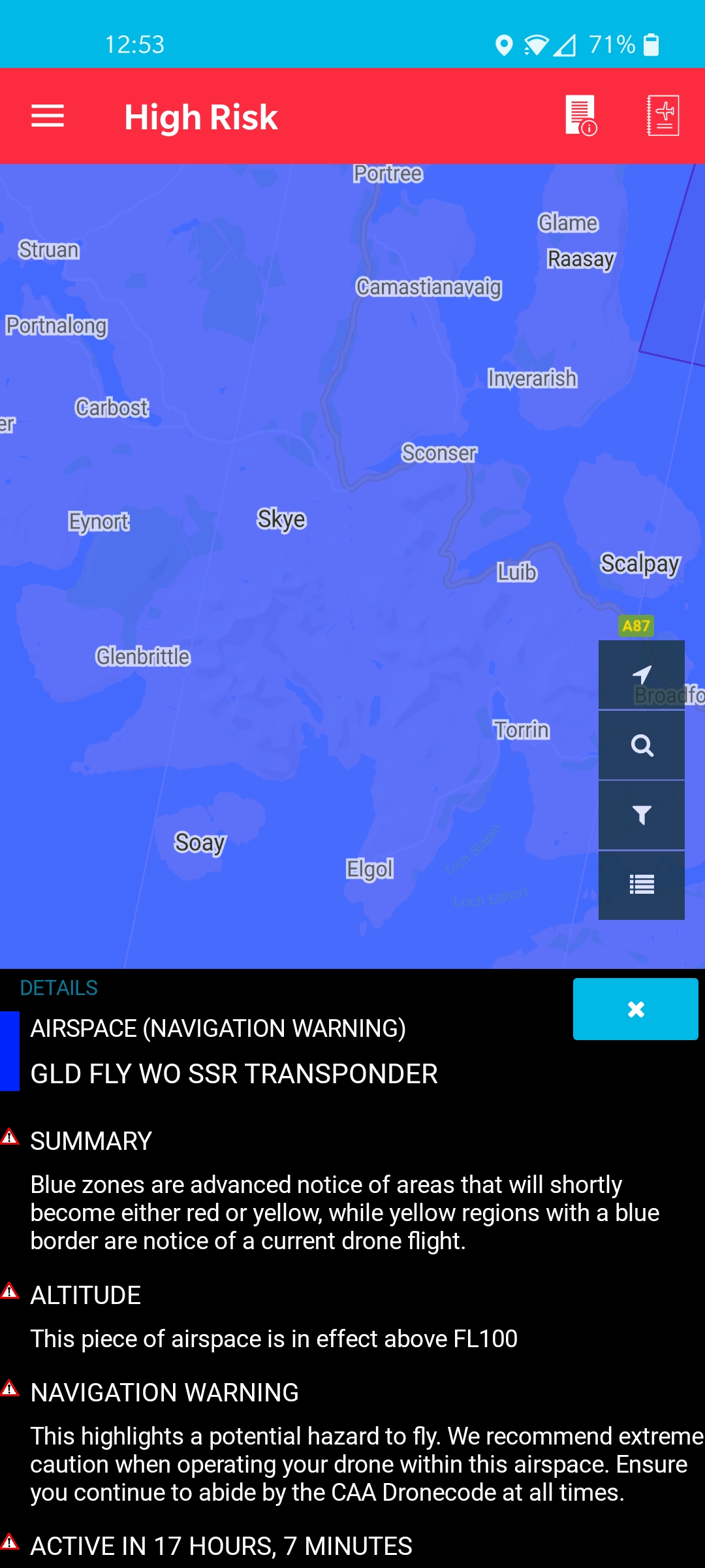
A NOTAM has been put on nats now for tomorrow, it says above FL100 which with a quick Google says that’s 10,000 ft? Does that mean I can still fly? I’ll attach a screenshot.
Ah, shame they aren’t answering to put your mind at ease.
Personally, I’d fly with what’s currently published. Even on the highest peak on Skye you’d still have more than 6500ft to play in before hitting that airspace.


 (BTW - you’ve posted your personal email address in an unlocked part of the forum)
 I’m new to the forum as you can see haha.