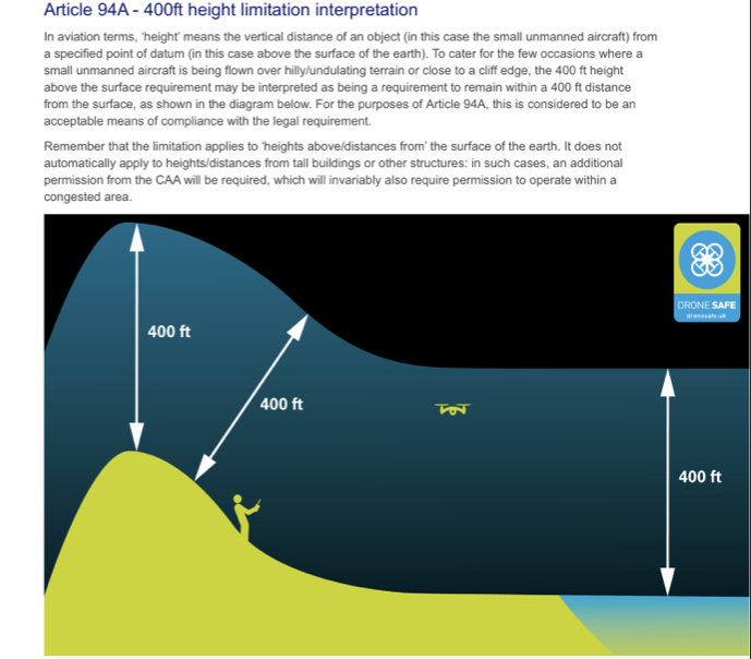
I’ve noticed a minor problem with setting the height limit on the mavic 2.
When flying this morning I took off halfway up a hill to get some shots of a castle. When I tried to get high above the castle for a straight down shot I hit my limit of 120mtr while only 80 mtr above the top of the hill. Which means the max height is set from the take off point and it doesn’t take into account the contours of the hill. This was with GO4 not sure if litchi does the same. May be worth keeping an eye on.
That’s the way it’s always been.
If your flying up a hill you need to raise your height limit.
Or take off at the top of the hill (watch out for the negative heights though)
I usually fly up them as I cant be arsed climbing them ![]()
Especially if it’s a precipitous cliff. ![]()
What if it’s owned by NT/EH? ![]()
I’m that used to a Pixhawk flight controller which takes that into account. I keep forgetting the querks of dji.
It has a global terrain height database in memory? 
I’d have been well down the road in that case, horrendous parking charges and lots of old do-gooders
Uses local Google map data which is what mission planner and tower the 2 apps ( which is the ground station software ) use
I didn’t say you had to get that close! Heaven forbid! 
Now that is high, I’m sure the CoE might have a little claim on that airspace ![]()
But they would only levy a charge as you end the flight. 
What is the height limit base - above sea level? Never thought about this?
Wow!
