Hi to all,
Question from the floor. I’m planing a camping trip to Snowdonia National Park and will be making a recording of my adventure, not going to trek all the way up the mountain, I was looking at drone scene and there appears to be so much of it out of bounds to drones. I understand the SSSI’s but lots of it shows Military flight areas. Just where am I allowed to fly, will be setting off from Llanberis along the Llanberis path. Many thanks for any assistance given.
Kr
Dave
1 Like
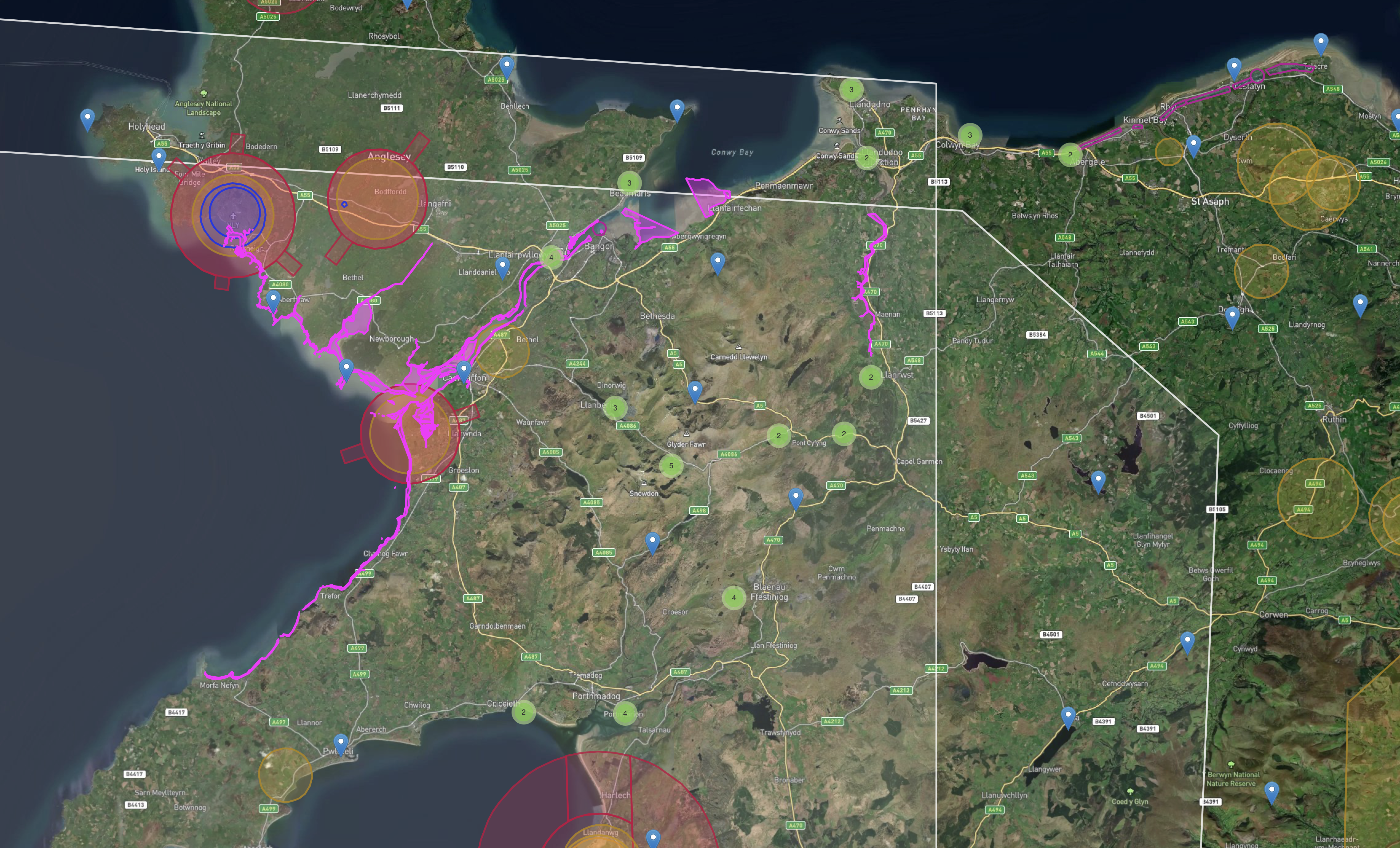
I’d imagine its the Mach Loop that the OP is worried about. There are no restrictions but very noisy aircraft can appear due to the proximity of local training centers at RAF Valley.
Weekdays tend to be the worst
1 Like
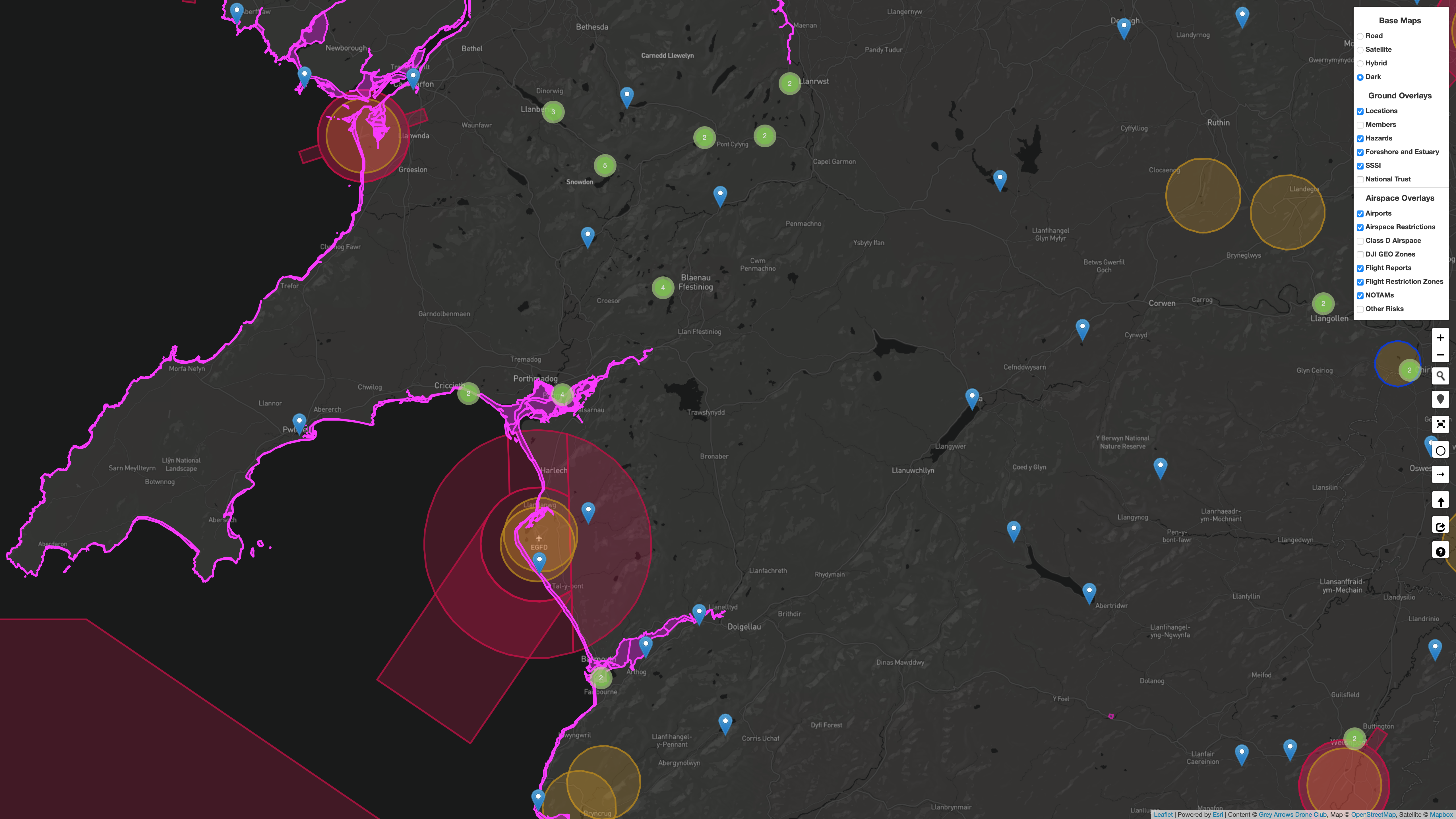
Hi Dave, from what I can see on DS, the flight restrictions seem to show a blanket across most of North Wales and SSSI restrictions local to the Llanberis path, as you suggest.
Do you know Eryri (Snowdonia NAtional Park) covers about a quarter of North Wales, or nearly 10% of the whole country? “going up the mountain” could be anywhere in about 800 square miles ![]() but for Yr Wyddfa (Snowdon itself), just keep an eye out for rescue helicopters and birds if it’s nesting season. Llanberis valley is typically avoided by RAF jets due to the high likelyhood of mountain rescue flights (RAF helicopters included)
but for Yr Wyddfa (Snowdon itself), just keep an eye out for rescue helicopters and birds if it’s nesting season. Llanberis valley is typically avoided by RAF jets due to the high likelyhood of mountain rescue flights (RAF helicopters included)
Elsewhere in the park, the main areas to avoid for low flying aircraft are the A487 from Cross Foxes to minfford (“Mach Loop”) and the A5 from Capel Currig to Bethesda ("A5 pass - Llyn Ogwen). If you’re hill walking you can easily get above the planes in both locations, and they tend to appear at high speed without notice, so easier to just not fly than take a chance.
Most of the rest of the area is SSSI, so pay attention to birds/wildlife & fly with caution, and National Trust - but most of their land in the park is open access so the usual “NT no fly” doesn’t apply.
1 Like
Are you referring to the AIAA and ATA Valley?
If so, as above, they’re not flight restrictions.
1 Like
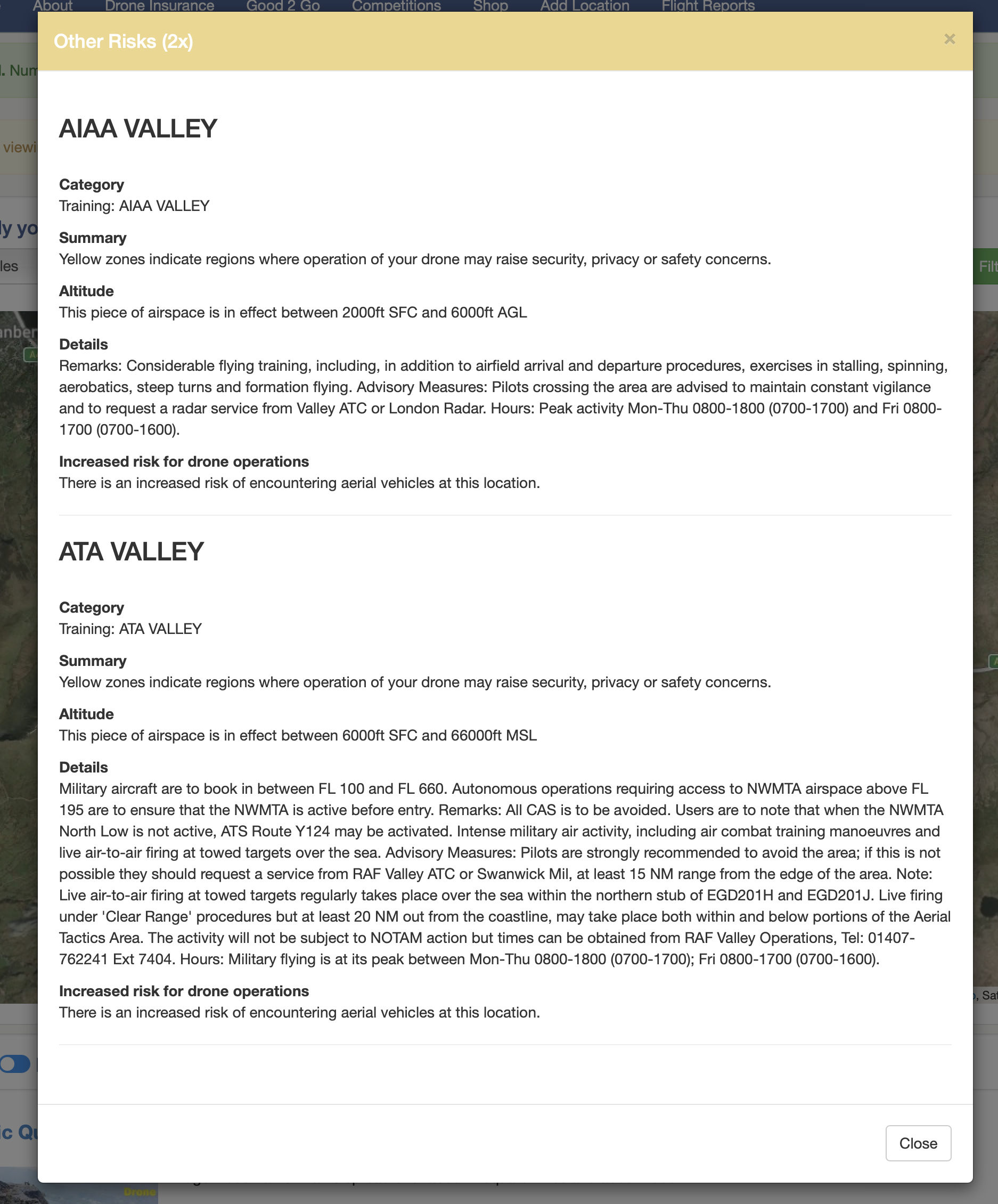
Very much a cautionary warning, absolutely not a flight restriction ![]()
1 Like
Note too, the altitude those cautions in your screen shot start at.
They start far higher up than the 400ft a drone can fly ![]()
2 Likes
The OP stated he was going to go part-way up the mountain from Llanberis along the Llanberis path, which is a good way clear of any FRZs. The whole area’s an SSSI, but that is not a restriction and you can fly anywhere within it, within the CAA’s Drone Code rules, which cover disturbance of wildlife and other people. You are not going to bother plants or geology much!
If you’re not used to the hills (and apologies for my trying to teach granny to suck eggs if you are), the Llanberis Path is the easiest way up the mountain, very safe, and well maintained; stay on it! That said, it is a long, onerous, and steep old slog, and mountain weather takes no account of how easy the route is and gives very little warning. Check your forecast, wear boots that support your ankles (not ‘trail shoes’), take layers of warm clothing and a waterproof (not water resistant/showerproof &c) outer layer, food, water, hot dring if you want. Turn back before you get tired, afterwards is too late. If you are caught in thick mist and/or darkness, head down and make sure you stay on the path; in poor light it all looks the same! Take a walking pole; your knees will thank you after the descent! And take a torch in case the trip takes longer than expected.
Try not to have to land the drone off the path. Even if the slope doesn’t look too bad, crossing rough ground is difficult and potentially dangerous, and makes life harder for those trying to locate your remains… Obviously, stay away from the precipitous drop to the left as you ascend past Clogwyn Station (if you get that far), but there’s some steep slopes to the right as well!
Take proper care, enjoy the walk, and enjoy the flying!
1 Like
Thanks very much to all that kindly gave information, answered all my questions and some.
Regards
Dave
Love the ’ for those trying to find your remains ’ …classic ! lol.
Easiest way up Snowdon is on the railway! ![]() I hated the Llanberis route up. Pyg Track and back by miners Track from/to Pen y pass is the easiest (ignoring the rail of course) as it starts higher up from the carpark!
I hated the Llanberis route up. Pyg Track and back by miners Track from/to Pen y pass is the easiest (ignoring the rail of course) as it starts higher up from the carpark!
Carpark has to be booked in advance now but there are shuttle buses from Llanberis. ![]()
The railway track is definitely the easiest way down, select a flat piece of rock suitable to sit on, place on central rack n pinion, sit on rock, place instead of feet on outer rail and enjoy the ride.![]()
Used to camp at blean y nant, take the direct route up via grin las & clog y station to climb on clog y arrdu. Continue to summit, ride the rail and bail just before clogy station to descend back into the pass.
Instead should read instep .