I hope this ends up in the right place - didn’t want to post in Drone Scene category because it’s about one specific place, not a general question to do with it, if that makes sense; if not, mods pls move it wherever you would like it !
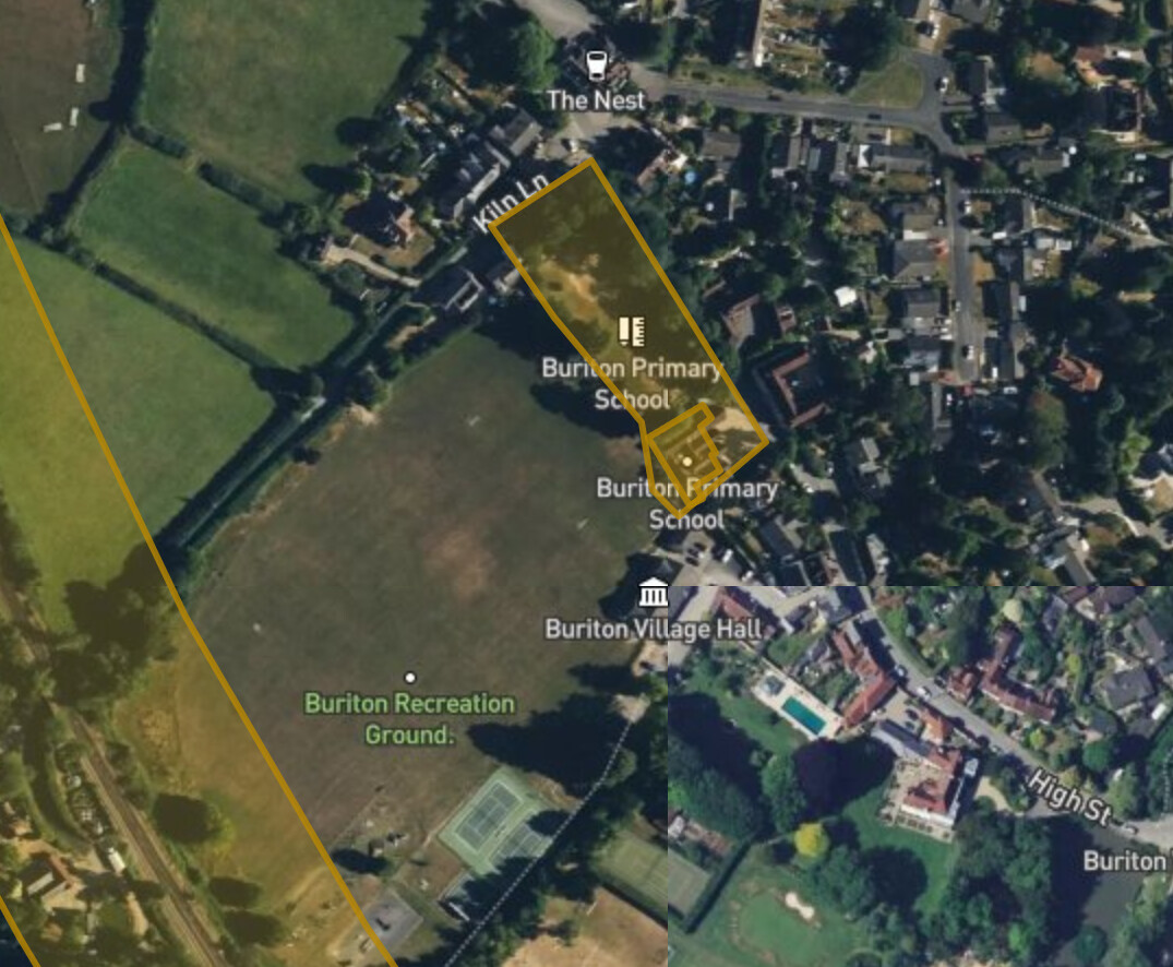
OK - Let me introduce you all to Buriton Rec - a seemingly perfectly charming wide open recreation field in a charming little picturesque village in the Hampshire hills that looks like it might be a lovely place to fly, nestling as it does, in the shadow of QECP and the Halls Hills site just up the road…
There is already a map pin at the other end of the village down by the church and lake, so in some ways Buriton is already covered, but I suspect the main rec ground deserves another one because it seems so obviously the place to fly in that village, and in theory it is ! In fact the local model RC club use it for flying their planes.
But I am very hesitant to just add it to the map without telling you all about what I can only describe as the ‘Curse of Buriton’ !!!
I have flown from this site 3 times, with 3 different machines (2 of them Naza-M based) and on each of those occasions after a few flights of normal behaviour my DJI machines have all inexplicably ‘gone nuts’ in this field, and done all sort of crazy flyaway-type behaviour that has caused 2 big crashes, and that leads me to think there is something seriously environmentally wrong here, and if I am right about that, then we maybe should pin it as a DONT fly here warning !! My old Yuneec Typhoon H is the only UAV that has survived a flight session here, and having lost 2 whole craft to this field (apparently no pilot error involved both times) I wonder whether I should try one with the M4P and see if DJIs resistance to environmental factors can avoid the same fate ! I suspect not - the views here are at best ‘OK’ and a way short of spectacular !
I don’t know what the hazard could possibly be - there is a railway track running all the way along the back of it, but that has not been problematic in other places. There doesn’t seem to be any big metal structures around, and only a playground and some tennis courts in the field. My crashes here have been uniquely weird and inexplicable (and before the days of logs alas) so…
Just my thoughts, but a “known Hazard” pin showing as described above a seemingly innocent area with issues would be useful for people surfing Drone scene looking for potential TOAL sites.
I am particularly interested in anyone else that wants to fly here with a modern DJI UAV. I would HOPE that their GNSS / IMU tech has improved a LOT since the Naza days, and that any environmental threat that was here is more successfully rebuffed by modern machines.
OR it could be merely that my particular FC had an intermittent IMU / compass problem !
I believe it was the same FC in a different craft a few years later when it crashed again, though of course that had done 2 years of flawless flying since the original incident, which might suggest otherwise…
But only having the PLI insurance and no care / refresh I am not keen to test this myself as I can’t really afford to lose another one in the attempt should it all go wrong again.
This was the crash (not in the Buriton field incidentally) that officially killed that unit forever, destroyed my beloved TBS Discovery build, my trust in DJI completely, and my interest in the hobby for a couple of years !
It would seem that it takes 10 years (and a sub-250g rule change) for me to give DJI another go, hence M4P ! But I wanna hang on to that little puppy if I can, for as long as I can !
This is lime when people get google street view to mask their house. People wanna go just to check it out. I am sure enough people will be checking put this land now. Will not be ling before you get an answer… @clinkadink likes testing drones that go missing.
Yep - works for me - we can narrow down the time on the day when we’ve seen what the weather’s up to… hopefully less hot than today ! What ya flying with ?
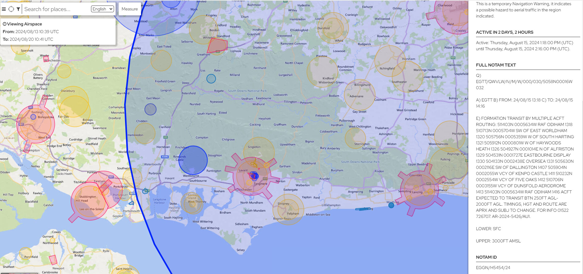
Good lord, that’s a massive NOTAM coverage area !! Virtually ALL of the South East from Hastings to Portsmouth !!
Forgive my ignorance, but is there any way to tell in advance whether this zone will become merely a yellow warning area or a proper red FRZ when it becomes active (without calling the NOTAM number) ?