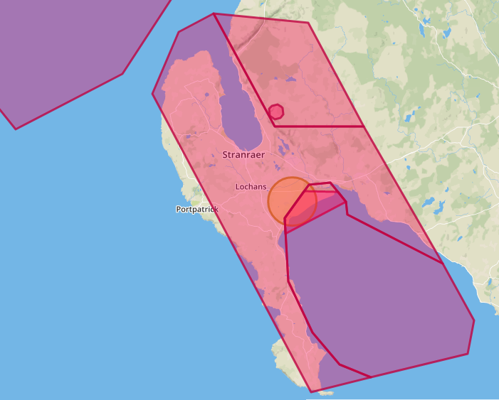
I was looking at somewhere quiet to get away for a week and a friend already holidaying there recommended a secluded country cottage near Stranraer. Seemed ideal.
Checked it out for being drone friendly and was disappointed to find almost nowhere legal except some small slivers of coastline. I can see obviously there is an airport restriction but much of the rest of it is a generic “don’t do it here” for the area with no specific indication of risks.
Not arguing with what is clearly a fait accompli but I would like to know out of curiosity for what reason(s) that area is no go for drones. Maybe the airport simply controls the whole area? Not using these maps too often I’m more familiar with circles than polygons. I know there are ferries at Stranraer and Cairnryan which might affect matters. Maybe there is a lot of RAF/military activity not widely advertised? Maybe someone familiar with the area knows?
I will clearly have to look at somewhere else. Any suggestions for a drone friendly holiday destination in say Scotland before we get banned from going there? I would fancy Skye (been there before but it rained all week) but availability and price are a major issue.
I think it’s got something to do with potential RAF manoeuvres and the range there will be activated by NOTAM if it’s being used. Check before each flight to make sure it hasn’t been activated, but if not I’d say you’d be okay (sticking to the drone code obviously) but keep your eyes extra peeled.
Thanks Joe very helpful - I think! The DroneScene maps when Restricted option is selected seemed to indicate to me at least, a restriction/prohibition. I interpreted the Danger text as a generic reason why the area is restricted and decided that meant prohibited.
I have previously taken Restricted Area on the DroneScene map to mean don’t fly there. It would appear it means it is possibly dangerous to fly there, is actually allowed but check carefully and be extra aware of danger. Is that the case Joe? Am I getting closer in understanding?
I personally don’t find it very clear or helpful for the DroneScene text then to lump in Danger, Prohibited and Restricted Areas in the further text. It would be much easier if somewhere it said Red means NO Pink means MAYBE with care. Anyway looks like it may be worth a trip there. The additional map you supplied was also helpful Joe, thanks for taking the trouble.
I’m going to pre-empt any of the guys involved in developing/maintaining dronescene and say that at the end of the day there’s really not a whole lot of difference between restricted areas and danger areas - both types of area can mean a blanket “No flying here”, both can mean “No flying here at certain times”, and both can mean “You can fly here UNLESS the area is activated”. They probably can’t separate them in Dronescene as they’ll come bundled in the same layer of data.
And there’s also not a lot they can do to clarify the text in the popups as that’s what’s supplied to them in the data. If you have the NATS Drone Assist app you’ll find it shows exactly the same wording.
If it’s somewhere you really want to fly then it’s always worth trying to find out the specifics - for me that usually starts with a simple search of the name in the popup and the type of airspace (so for you it’s “Luce Bay Danger Airspace”) and see what comes up.
But if you’re unsure then you’re best to do as you have and assume you can’t fly there.
As you say, red means no… unless you’re sure it doesn’t
MOD West Freugh Range (formerly RAF West Freugh) is the reason for the restrictions It is operated jointly by Qinetiq and MOD. It occupies some 750km² of airspace, 380km² sea area, and 12km² land area (comprising hard and soft target areas). The runways are disused and unlicensed but available for military exercises.The Range can be used for for military training, bombing, lasers, UAV testing (!) or a parachute drop zone. We holiday in this area and the walks along the foreshore can cause anxiety. There are red flags flown when exercises are taking place. Fabulous scenery worth a visit.
There is a query on here going back to last Aug about Restricted/Danger areas where they dont tell you what is going on.
You can find out from the nearest LARGE airport to the area, as they receive details of activity (date/times/what is going on) whenever the area is active. The CAA Aeronatical Information Service issues a daily NOTAM of activity on Danger areas. Restricted areas…Royal Flights/VIP flights (if any). These are then usually plotted on a Danger Area Map where pilots can see where and what activity with details is occuring.