This post answers your question.
It’s VERY important to understand the differences between DJI’s NFZs and those areas that are specified on DroneScene / Drone Assist, etc.
This post answers your question.
It’s VERY important to understand the differences between DJI’s NFZs and those areas that are specified on DroneScene / Drone Assist, etc.
Whenever you perform a firmware update to the drone, always check if the batteries are also in need of an update by powering up with each in turn. The one in the drone when the firmware is updated will (99% of the time) be automatically updated … those not in the drone will not be.
I did actually do that when I charged them up and there was no suggestion of update needed.
However thanks for reinforcing.
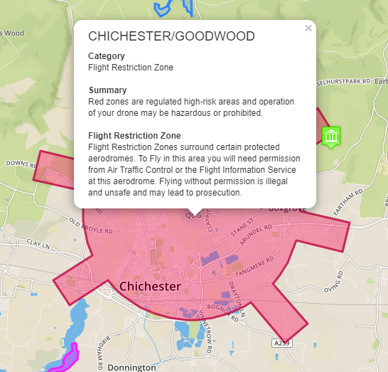
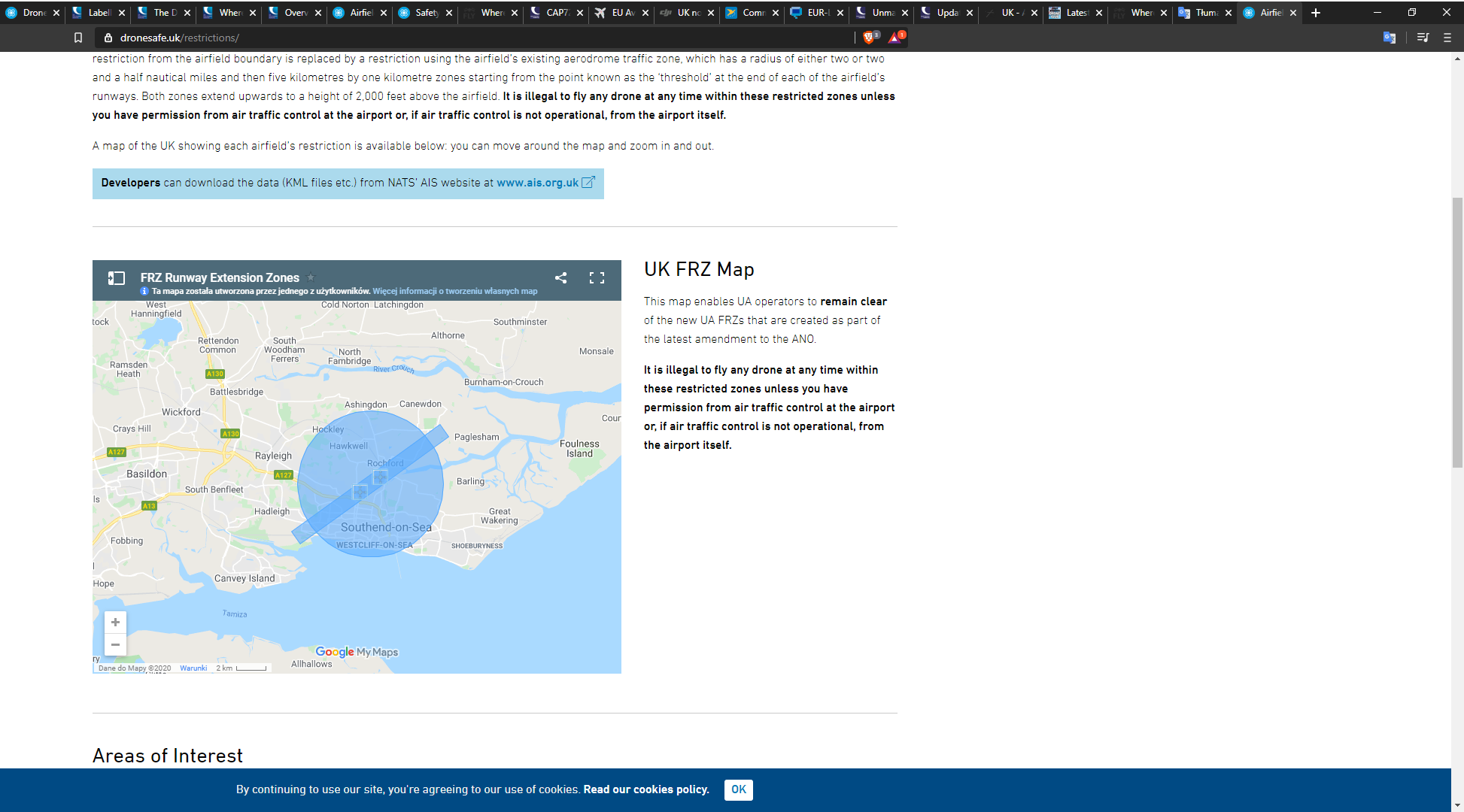
Do you mean something like this? Here you’ve got the airport in the middle with an additional zone around it. The reason for this is because it’s an airport control zone and likely to have high volumes of air traffic. This makes it “High risk”. You can fly here and a quick phone call to the ATC at the airfield is always appreciated. Essentially you’re likely to be on the approach or departure from the airstrip. If the tower can advise the pilot that there is a UAV at X position in advance it saves a whole world of issues.
In other areas it’s really advisable not to fly in this CTR zone as anyone who has experienced the sudden appearance of a Chinook or Apache at hedge height will tell you.
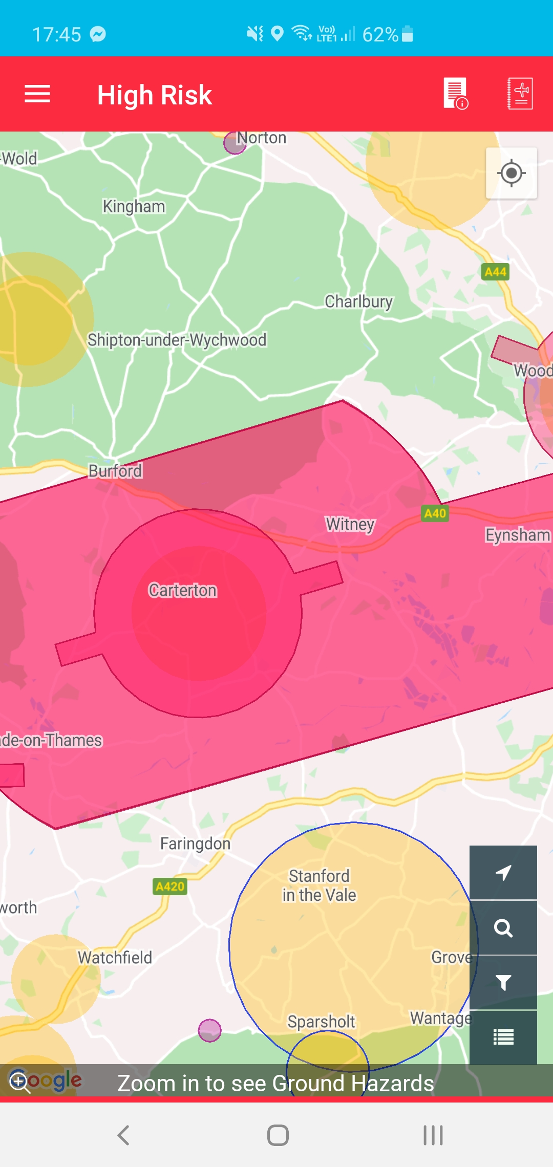
Thanks @Pterodactyl . Doesn’t seem to be much difference between the various maps I checked DJI included. Right on the edge.
Could you perhaps explain indeed if there actually is an explanation why an Airport restriction circle in Dronescene is included inside a larger Airspace Restriction circle. Why not just the one circle? In other words why is there an extension to the obvious Airport NFZ. The airport is actually not commercial and hardly used except for the occasional light aircraft and helicopter. I do understand if it is used then it needs protection. Unfortunately I live within sight of the airport so have to travel some distance to fly. It puzzles me why an extension is needed on top of the understandable Airportt NFZ.
Thanks @leeheyes for your explanation of the additional surrounding zone which came in as I was writing this. As pointed out this particular airport has almost no traffic and wouldn’t seem to need additional protection as the location in question is nowhere near any runway path. There is also a military field used for testing jets etc. and a temporary home for Red Arrows which has some overlap with the airport NFZ but it doesn’t actually encroach on the location I am interested in at all.
Thanks both.
NFZs = DJI
FRZs = UK Legislation
So - not sure exactly which you are referring to.
There will be a difference between DJI’s NFZs and UK’s FRZs because they have dimensions that are specified differently. (And DJI’s NFZs have three different size implementations and varying altitudes under the runway extensions. See this post).
DJI’s NFZs control your drone - and whether it can actually take off, and whether it can fly into the space defined by the NFZ - by controlling it. They do not prevent you flying into UK spaces illegally.
DroneScene only considers the UK legislated spaces.
UK’s FRZs are drone specific and relate only to airports (not all airports, however, many very small airports not having an FRZ).
FRZs all have their size specified identically … as 2.5km radius from the centre of the airports runways with extensions from the ends of, and inline with, each of their runways for 5km in length and 1km width … and are relevant only to 400ft agl and below (since you need permission to fly above 400ft in any case).
eg: Goodwood’s FRZ - with it’s three runways.
Other UK air space that can be displayed in DS is relevant to all aviation, not just drones. There are no (very few) standard dimensions. They are specified as the size deemed necessary for their use and safe flying by ALL non-drone aviation, and the rules that govern them.
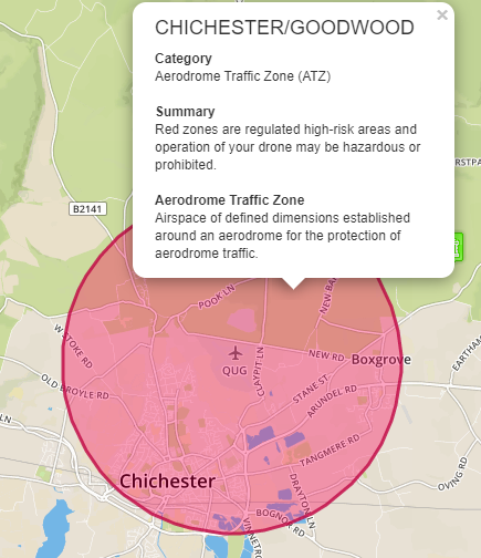
The usual zone that is found around most airports (but not all small ones) is the ATZ (Air Traffic Zone).
eg: Goodwood’s ATZ.
It just so happens that Goodwood’s ATZ is also 2.5km radius … but this isn’t always the case, and can be larger.

I’m convinced they make it up as they go along ![]()
It’s also the reason so many people mod their DJI drones to remove them and instead rely on actual UK FRZs as mentioned above, plus a bit of common sense ![]()
I had the joy of DJI today. Having embarked on a 250 mile round trip that included a couple of places to photograph for a certain competition I was decidedly non-chuffed to find that my launch site, outside of an FRZ was claimed by DJI as in the zone. I had checked for any problems prior to setting off using Dronescene.
The launch site was on the border of NT land. The FRZ was several hundred yards to the north. DJI plastered a BFO notice over my screen and, as I had no internet access (I assume) I coudn’t clear it.
Fortunately I had Litchi on the tablet as well so a reboot brought up thet ap. A small banneradvised that I was very near an FRZ. I tapped the message and it went away. Thank god for some grown-up software!
Thanks @Pterodactyl for detailed explanation.
My fault for using NFZ rather than FRZ which is what I was intending to refer to rather than DJI’s NFZ terminology. In fact as said I couldn’t on this occasion see much difference on the maps for this area.
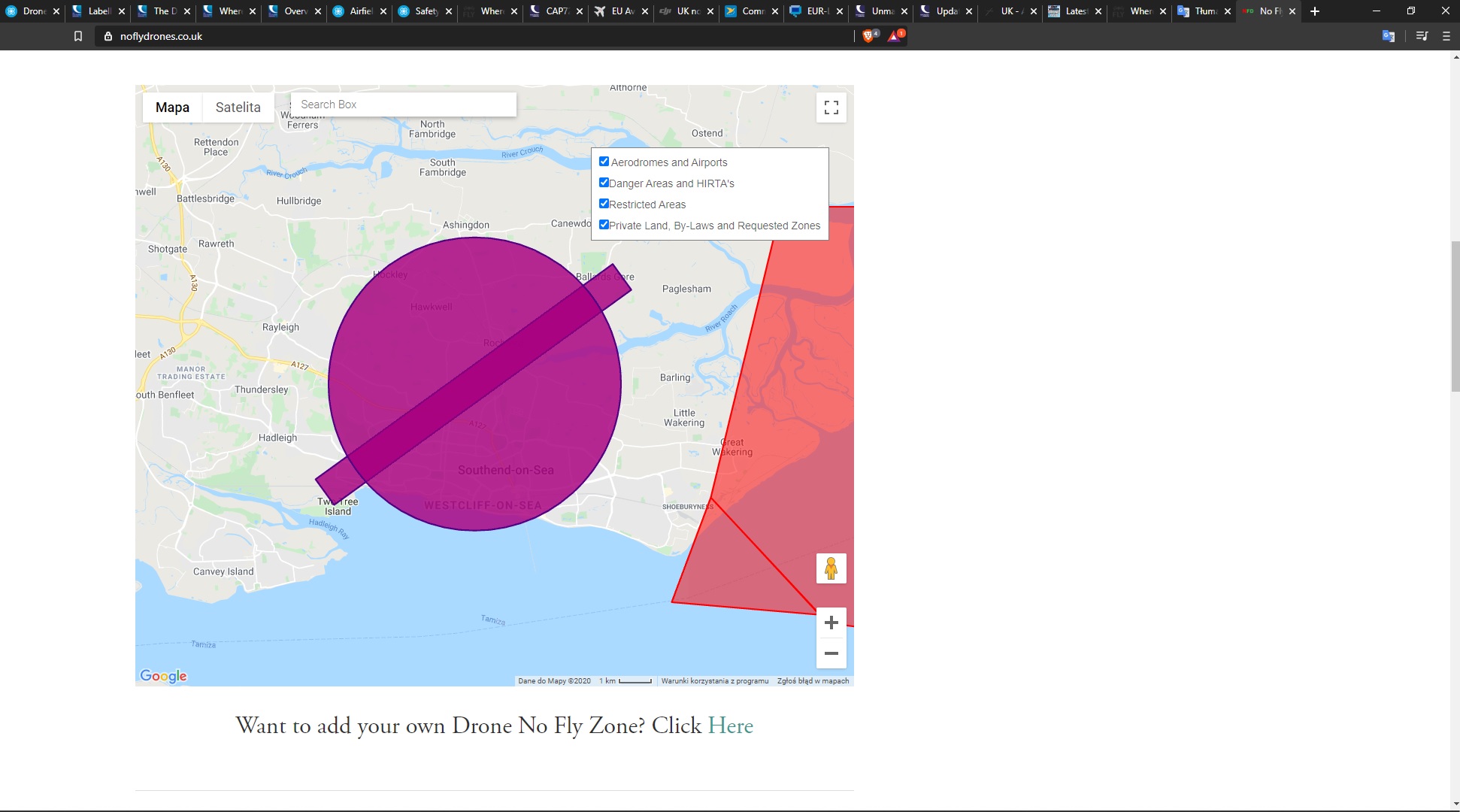
My location/field is roughly where the purple blob on the dronescene image indicates. If I understand it correctly now, the inner circle is the statutory fixed radius for UK airports and the outer one is an additional safety zone for some additional reasons of safety that may or may not be added in all cases. Since the airport is hardly in use now it is hard to imagine why an additional safety net is needed. So be it.
Probably best to contact ATC and see what they say.
Or keep to the drone code.
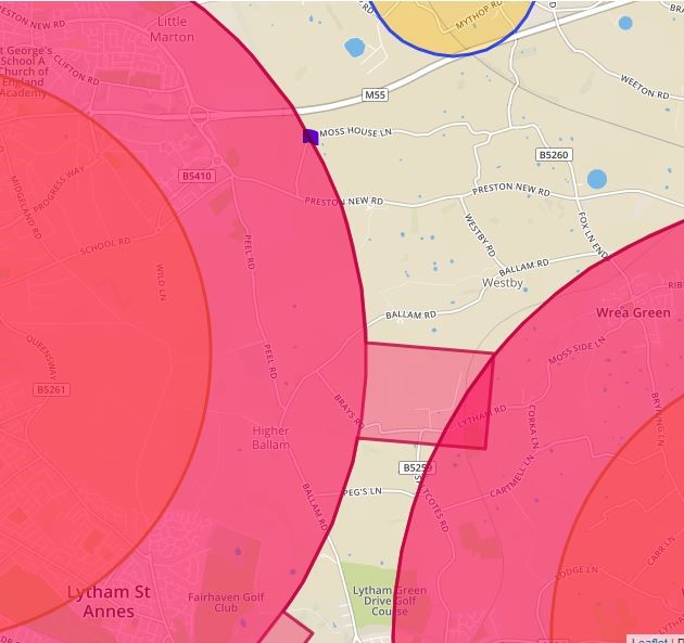
At this particular location (which I think @stevesb knows well), the outer zone shown is the legal FRZ. The inner zone is of no real relevance to you. To keep your life simple in this instance, perhaps just switch off every layer on Drone Scene except the FRZ, and then switch the others back on one-by-one to see where they are relevant.
As @kvetner said I do know this area the outer ring is the FRZ. The other issue you can fly outside it but don’t encroach. ATC Blackpool are quite strict on they won’t give permission without a PfCO. However saying that It’s not on the DJI Go4 as a NFZ so you can take off if you wanted to risk it, but I didn’t say that and obviously wouldn’t endorse it.
Hi everyone im Paul
I will start with the fact that I am the new owner of the drone (for now MAVIC MINI).
For 3 weeks I have been flying about 30 minutes more time reading the legal regulations regarding drones. I have read all the pages of the internet by now hahaha.
This is my bookmark collection
 caa co uk
register-drones.caa ( I finish registeration )
nats.aero
dronescene
noflydrones and more…
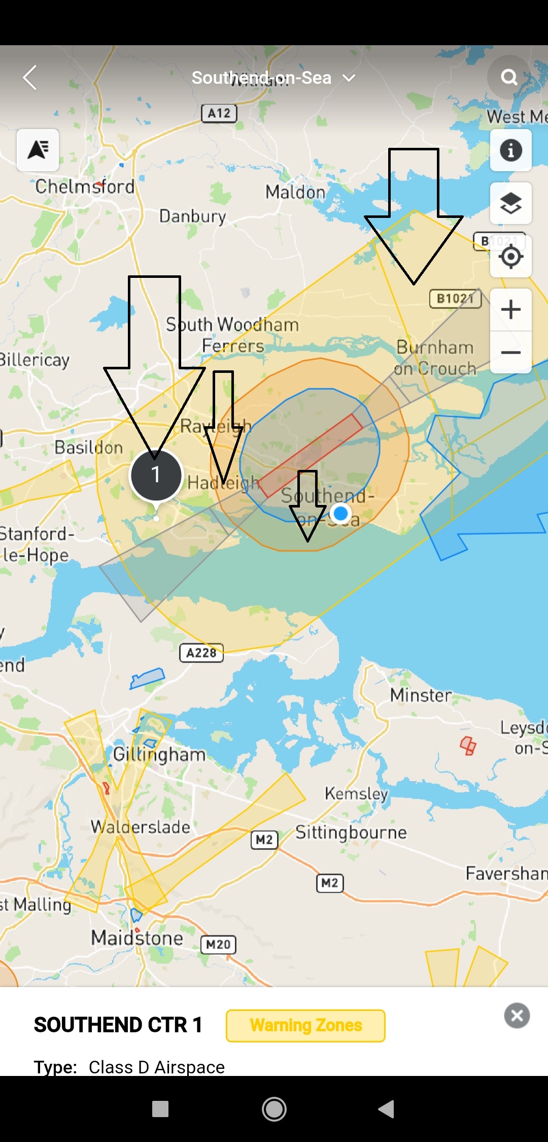
I can’t find any exact information about the CTR zones.
I would like to fly in this zone max 200ft (50-60m) is it possible? do i need to register a flight to CAA? is it enough to report to DRONE ASSIST?
Pic below you can see what my zone looks like
I would like to fly where the arrows
I have more pic from | Drone Assist | | Airmap | | noflyzones | , but I can add only one in my post 
Hi @paulvanb.
You should be OK to fly in the areas you have highlighted, subject to any local bylaws that may restrict drone use if any.
Your places of interest are in Class D airspace which is usually fine to fly in with no special permission. As an example there are three model flying clubs in my area of Class D airspace, the one I’m a member of has special permission to exceed the normal 400ft maximum ceiling height, this is for LOS model aircraft and doesn’t include drones.
Nidge.
Thanks for answer Nidge
I know everything about ground hazzards in my area
I need join to the club when I fly in Class D? or its just for flying more like 400ft?
And Can I fly 200ft where the arrows yes?
whether to report a flight in drone assist?
Yes Paul, in Class D airspace you’re pretty much allowed to do, barring ground restrictions, anything and everything as detailed in the Dronecode, including up to and including the 400ft max ceiling height. You don’t have to be a member of any club, I just cited mine to show that in ClassD airspace the restrictions are generally few and far between for recreational model flyers.
Nidge.
Ok. BIG thanks for very helpful answer. I really appreciate 
have a nice weekend Nidge