Does this mean it is possible to remove the yellow overlay that makes cached maps in the DJI app almost unreadable. One such area covers a Class D airspace in which I frequently fly.
Peter
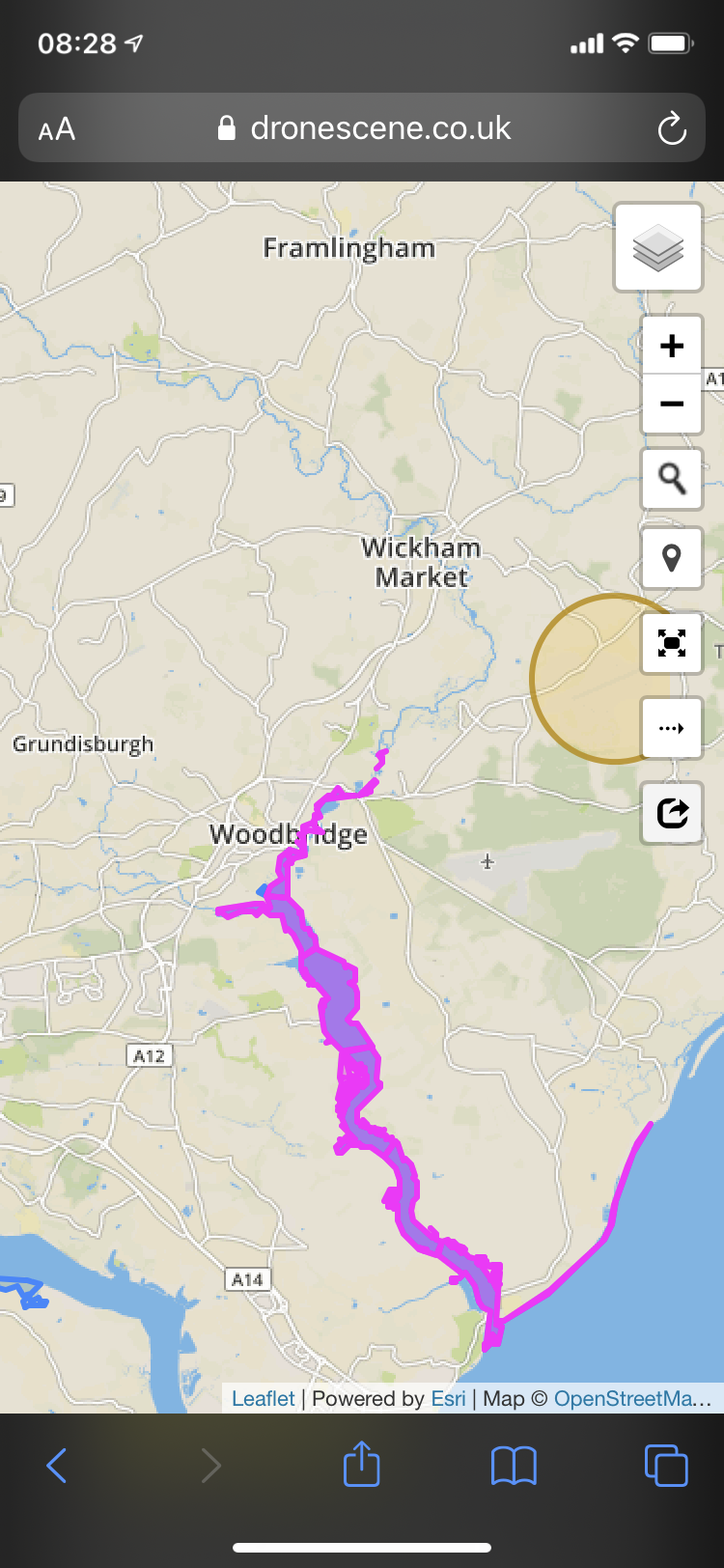
I’m going to Woodbridge, Suffolk this weekend and have been looking at maps to try and work out where I’m safe and legal to fly around there. In particular, I was thinking of trying to take some snaps around the river Deben. However, I’ve noticed that this is kind of near MoD Woodbridge airstrip. In fact, the river itself appears to be 5km almost exactly, from the end of the runway around about where I was thinking of sending my drone up.
When I check out Drone Assist, Airmap and DJIs Altitude Zone it doesn’t draw one of the restricted zones around the airstrip. Does this mean it’s actually OK to fly nearer there or is it simply that a zone has not been drawn around this airstrip for some reason?
I see that other aerodromes and airstrips around the country sometimes also don’t have a zone drawn in these apps. Does anyone know what the story is here?
Thanks.
We’ve moved your post to this thread that probably has all the information you’ll need about the maps and their differences - particularly this post.
But ask again about anything it doesn’t answer for you adequately.
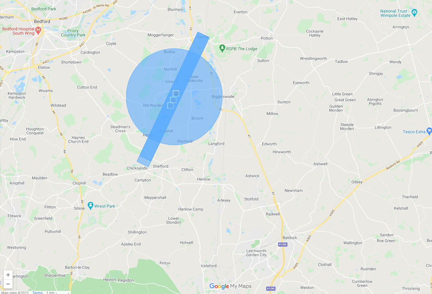
Hi, something that caught my eye was the FRZ circles on the map which I originally understood from the rules were 2.5km radius appear to be disproportionate in size to the runway protection zone that runs for 5km from the end of the runway, i.e. the pan handle should extend 2.5km beyond the circle but the appear to be a bit stubby. went to google maps measuring tool and found the 5km runway protection zone to be accurate (except some apps use the end of the tarmac and not the runway threshold**)
The FRZ at Bristol is approx 4.6km radius*, the FRZ at Colerne is 3.8km give or take.
Hence I’m curious as to how these are defined.
I’d go by the circles on the map as they are the larger of the two and keeps you safe, it’s just I used to fly model aeroplanes from a field that is 4km from Bristol Airport and if I followed the 2.5km rule thinking I was safe, I’d be in trouble because is its within the 4.6km FRZ circle.
- as measured from the centre of the runway to Backwell railway station
** Drone assist uses the threshold, so the Colerne runway protection zone stops at the A46
Airmap uses the end of the tarmac so the Colerne runway protection zone extends beyond the A46
They are defined by the CAA
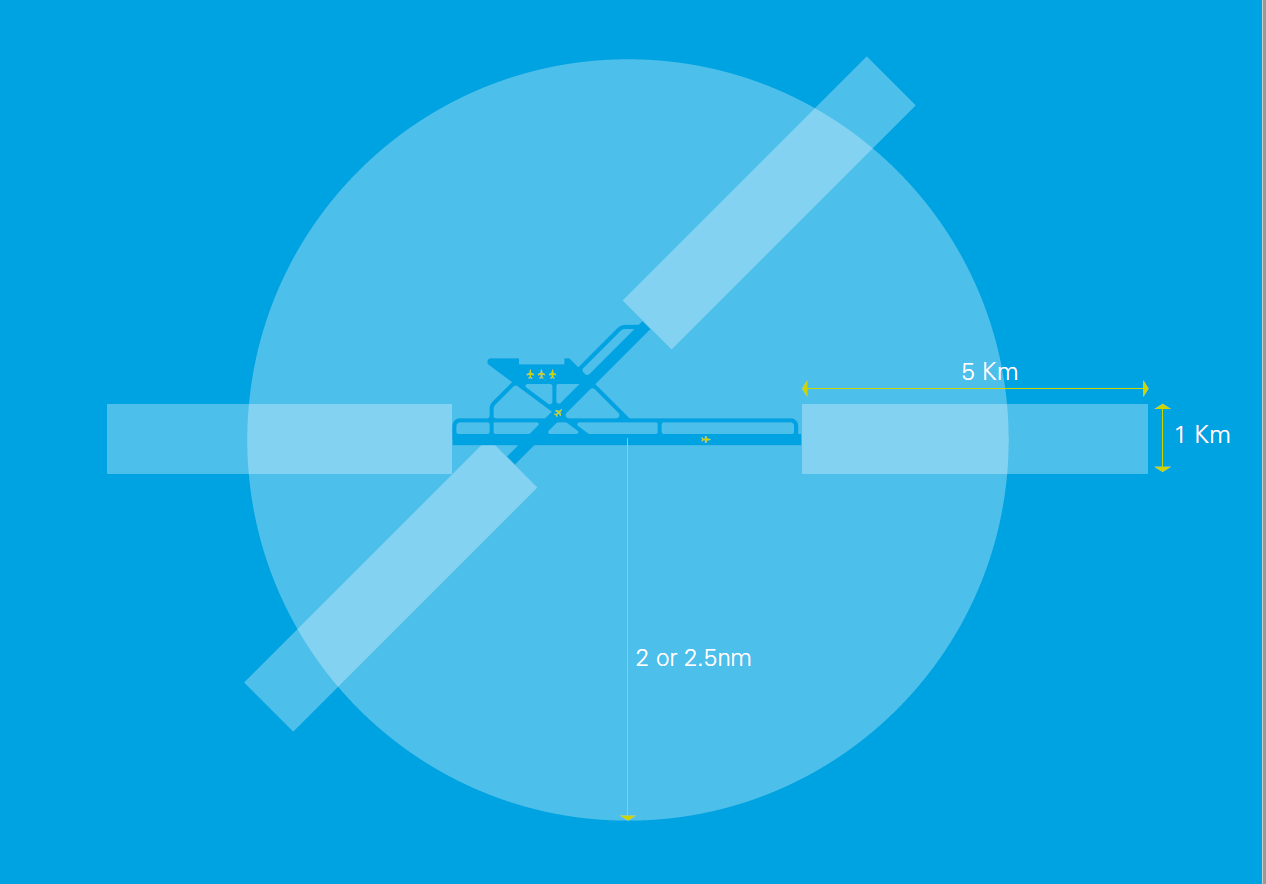
Flight restrictions around aerodromes
Flights of unmanned aircraft around airfields or airports that are designated as ‘protected aerodromes’ are tightly restricted. Unmanned aircraft of any size must not be flown within the Flight Restriction Zone (FRZ) of a protected aerodrome, without appropriate permission.
The Flight Restriction Zone consists of the following three elements:
The Aerodrome Traffic Zone: A 2 or 2.5 nautical mile radius ‘cylinder’ around the aerodrome, extending 2000 ft above ground level, centred on the longest runway.
Runway Protection Zones: A rectangle extending 5Km from the threshold of the runway away from the aerodrome, along the extended runway centreline, and 500m either side- also to a height of 2000 ft above ground level.
Additional Zones: In the case where the 1Km boundary of an aerodrome extends beyond the Aerodrome traffic zone, and so would not be protected by it, the flight restriction zone will include a ‘bump’ (the airfield boundary + 1KM) to protect this part of the aerodrome.
The exact shape of the Flight Restriction Zone varies depending on the specific aerodrome that it protects. Prior to flight, remote pilots should check to ensure that they are operating well outside these areas.
![]() That last para might be the most relevant.
That last para might be the most relevant.
Drone Scene uses the official data, as does Drone Assist … Drone Scene just has far more features.
Ah!, I see from that its 2.5 nautical miles (4.6km) not 2.5km. All makes sense now. The classic problem of mixing units
Thanks.
1 Like
I’ve seen mention of rooting DJI drones to avoid the sometimes incorrect restrictions the DJI maps have. Unfortunately I don’t believe rooting is an option for my Mavic Mini. Has anyone else had experience with convincing DJI to either remove a NFZ or agree to fly in one? My use case is an RAF base that ceased operations back in July 2020. No flying, RAF or civilian (there was a flying club there until recently) occurs at the base any more. I’ve put in a request explaining this, but they returned a (probably automatic) rejection based on the fact I didn’t have proof of approval. Is this something I could get if I contact the base?
1 Like
Does the associated FRZ still exist? Probably does.
If an airfield is still registered as active, irrespective of whether anyone flies there, it can still have a valid FRZ.
And if it does, you’ll still need to obtain permission to fly in the FRZ in any case.
Have you tried flying there?
No the UK FRZ list doesn’t have it listed. The red runway part goes through my town and my house so can’t fly in the garden, but it lets me fly in the blue if I do a self-unlock. @OzoneVibe @milkmanchris
Which airfield?
If there’s a “red runway part” … that is part of the FRZ.
I’ve attached a couple of screenshots that hopefully explain things better. The first is from Drone Safe website showing a FRZ to the North of me. This is correct, and I have no intention of flying in this zone.
The other screenshot is from the DJI map showing RAF Henlow which as far as I can tell ceased being used in July last year - Flying Info | RAF Henlow | Royal Air Force. Most of my town is in the red section, but I have been able to self-unlock for the blue section surrounding it.
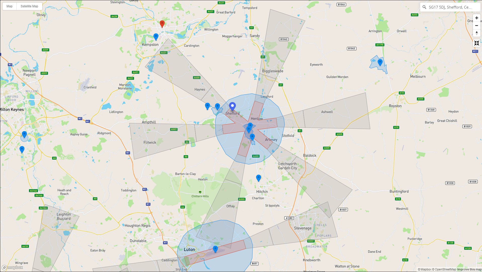
You may find using Drone Scene quite helpful (for viewing purposes) since both FRZs and DJI Geo Zones (and other useful info layers) can be viewed simultaneously. (Data for all layers is retrieved live from source data)

Alas no real help for your fundamental problem of flying within a pointless DJI Geo Zone for Henlow.
I’d guess it’s just a case of repeated attempts to get DJI to unlock … or remove the zone from their data. (Good luck with the latter!)
4 Likes
Ah, perfect, that’s exactly what I needed to see both on one map. I’ll use that in future.
I’ve emailed the base and had an email back confirming the base is no longer active and the restriction should only be over the boundary of the base itself, not the massive asterisk the map shows. I’ll PDF the email and my screenshots and try again at either a custom unlock or getting them to update the maps (unlikely, but worth a try).
Thanks again 
3 Likes
Let us know how successful you are, and exactly how you persuaded DJI … if indeed you do. 
Drone Scene was designed by drone pilots (us) for drone pilots (you). 
2 Likes
Well that was a success. I had one more custom-unlock request rejected due to the fact the RAF email doesn’t contain a date range for authorisation, so the maximum DJI will unlock for is a year. Submitted again with a 12 month date range (rather than the max 3 or 4 years on the online form) and it has been approved! I requested a 4km circle from the middle of the base.
I’ve downloaded it to my phone, but I’m supposed to be working, so not yet gone outside to see if the app lets me fly in the garden! Fingers crossed 
6 Likes
Cool!
I live near a major Airport. Leeds and Bradford Airport to be exact.
I recently sent a request for clarity on flying in their Air traffic zone. I live approximately 1km from their Flight restriction zone boundery. The ATZ covers a reasonable area and I have watched aircraft of all sizes using it, in normal times. Sometimes the power grid Helicopters fly parallel to the Pylon wires in the Aire valley. Obviously the Nats App suggests not flying there, however iff I do, to observe the drone code.
Now here’s the rub. ATC responded by sending me a copy of a form to fly in the FRZ, which requires approval by the CAA. I enquired again, stating I only want to fly in the ATZ and recieved the same response.
It appears they wish me to seek CAA approval to fly in the ATZ. Anyone else come across this issue. It would mean asking the CAA permission to fly my mini in my garden, everytime I want to fly it. It does appear like this is a standard response?
Clearly this will differ from place to place, but for Cambridge Airport the form also included a field asking whether CAA approval is in place. I simply included my operator and flyer ID and stated that no other approval from the CAA is to my understanding required. They approved my application on that basis.
4 Likes