New Feature
• Council Byelaws, Public Space Protection Orders (PSPOs) and Policies
Back in 2024, Grey Arrows Drone Club submitted a Freedom of Information request to every local authority in the UK, asking if they had any byelaws or policies relating to the recreational use of drones.
Not only have we done it again for 2026, but this time we’ve asked additional questions and we’ve mapped the results of every single council directly in to Drone Scene ![]()
Over four million data points make up and define the exact boundaries of each local authority.

Our 2026 round of FOI requests asked three very specific questions of each council:
-
Do you have any byelaws that are used to regulate, restrict, or prohibit the recreational use of drones from land under your jurisdiction? If yes, please provide:
a) The dates of each byelaw.
b) A digital copy of the byelaws or a direct link to the specific document or webpage where the information can be accessed. -
Do you have any Public Space Protection Orders (PSPOs) that are used to regulate, restrict, or prohibit the recreational use of drones from land under your jurisdiction? If yes, please provide:
a) The dates of each PSPO.
b) The locations and areas these PSPOs cover.
c) A digital copy of the PSPOs or a direct link to the specific document or webpage where the information can be accessed. -
Do you have any policies that are used to regulate, restrict, or prohibit the recreational use of drones from land under your jurisdiction? If yes, please provide:
a) The dates of each policy.
b) A digital copy of the policies or a direct link to the specific document or webpage where the information can be accessed.
As you’ll see, we’ve ask for the details of anything a council can use to regulate, restrict, or prohibit the recreational use of drones from their land – including any PSPOs.
A Public Space Protection Order (PSPO) is a legal power which can be used by councils to restrict certain activities in public places where those activities have, or are likely to have, a detrimental effect on the quality of life of people in the area. They’re similar to an Antisocial Behaviour Order. These PSPOs can impose conditions on how a public space is used, or prohibit specific activities altogether, and are enforceable by fixed penalty notices or prosecution – they’re important.
More information about each type of restriction can be found on the “about” page of Drone Scene at https://dronescene.co.uk/about#Byelaws
The results of our 2024 round of FOI requests were linked in to Drone Scene, which meant when you wanted to find out about a particular council you had to spend some time reading though our full request, and all the various replies we received from each council. Quite a time consuming task, but the answers were available to you nonetheless.
However, in our 2026 round, we have brought all the responses directly in to Drone Scene, so now Drone Scene knows the response ![]()
This means you no longer need to wade through countless FOI requests and responses, you no longer need to wade through some often very outdated byelaw documents trying to decipher them, we’ve done it all for you ![]()
You can now instantly see if a local authority has a byelaw, a PSPO or a policy that they can use to restrict you flying from their land.
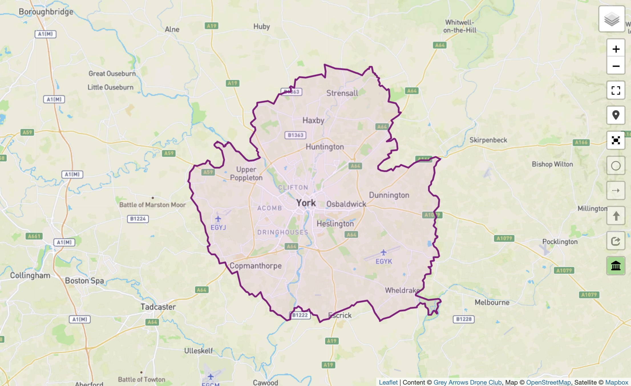
Each council boundary is now displayed in a different colour to quickly visualise any blockers that might be in place.
The council boundary will be green if the council has confirmed they have no byelaws, PSPOs or policies used to regulate, restrict or prohibit the recreational use of drones from land under their jurisdiction.

The boundary will be yellow if the council has a policy or PSPO that may restrict drone take-off or landing from land they own or manage.
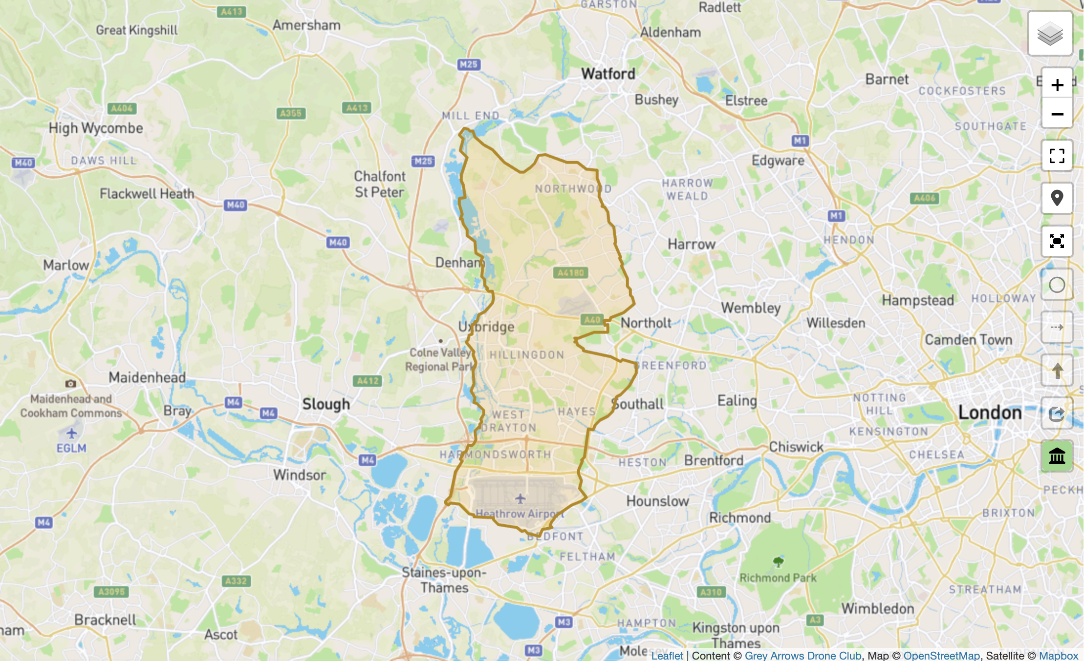
It will be red if a byelaw exists that restricts drone operations in one or more locations.

And in the short term, it will be pink if the council has not yet confirmed their status in response to our 2026 Freedom of Information request.
Furthermore, clicking on the council boundary will open a popup modal which contains a very simple checklist of the status of each council. Green ticks or red crosses give you a very quick indication of the status, along with a short summary of any specific or important details.
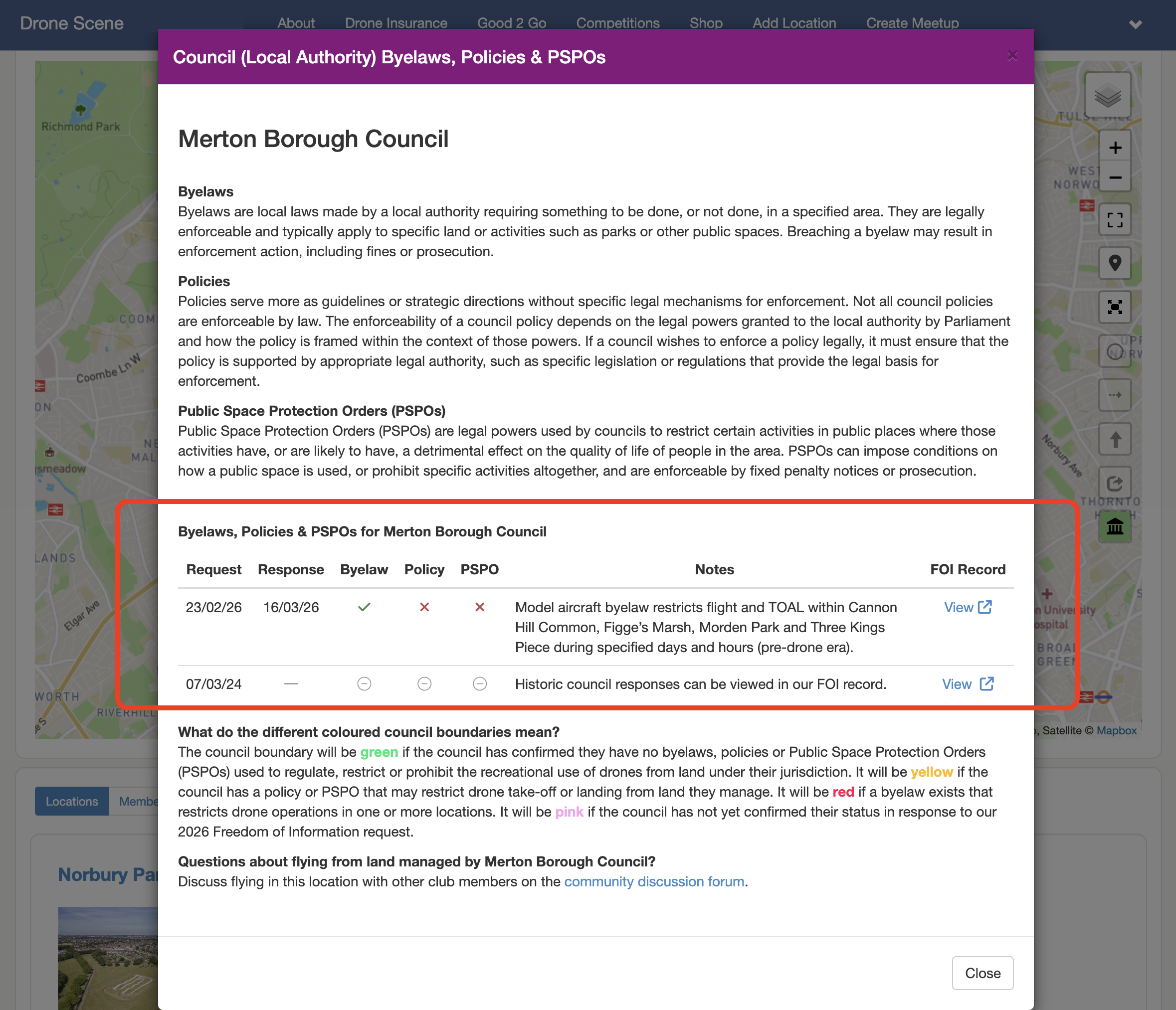
This table will build a historic picture in future successive years.
Also within each detailed popup is a link to view the entire FOI public record which contains every email we sent, every response, every legal document – providing you with full and complete transparency.
Access to this feature is included with Silver and Gold Membership.
If you’re currently a Bronze member, you can upgrade to unlock full Drone Scene access, including council data, competitions, and additional member benefits:
When reviewing FOI responses, it’s not uncommon to encounter vague or ambiguous replies, where councils present documents in a way that suggests they carry more regulatory weight than they actually do. We’ve worked through these responses carefully to ensure the outcome presented in Drone Scene is clear and accurate.