The originator declared that this location was not inside a Flight Restriction Zone at the time of being flown on 10/07/2025. It remains the responsibility of any pilot to check for any changes before flying at the same location. Landowner permission may be required before taking off.
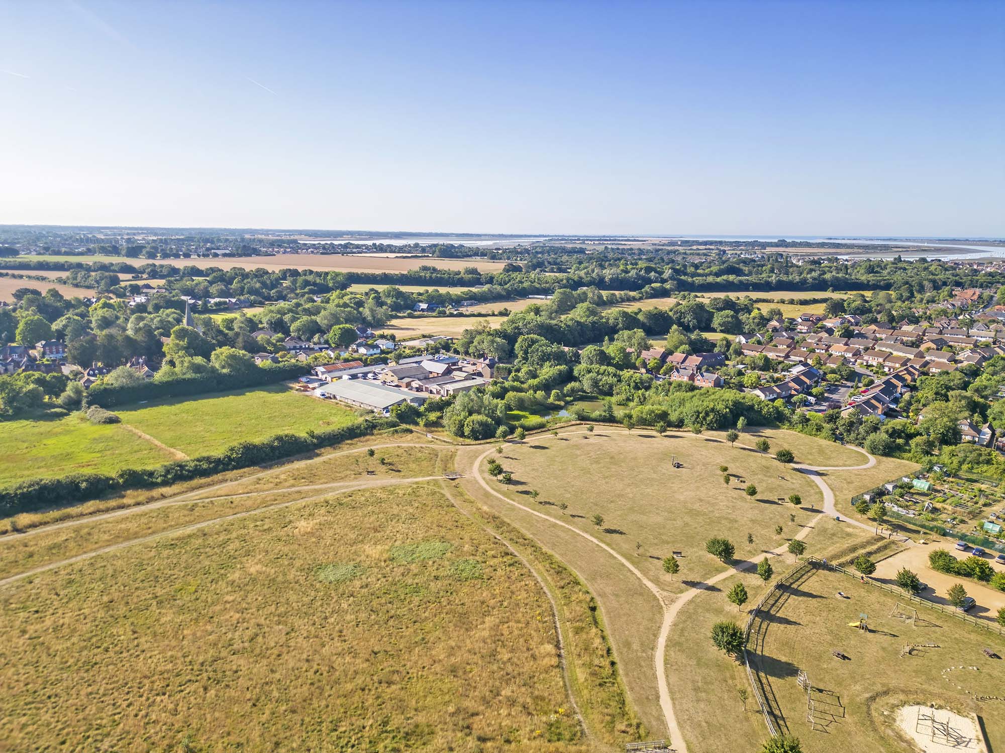
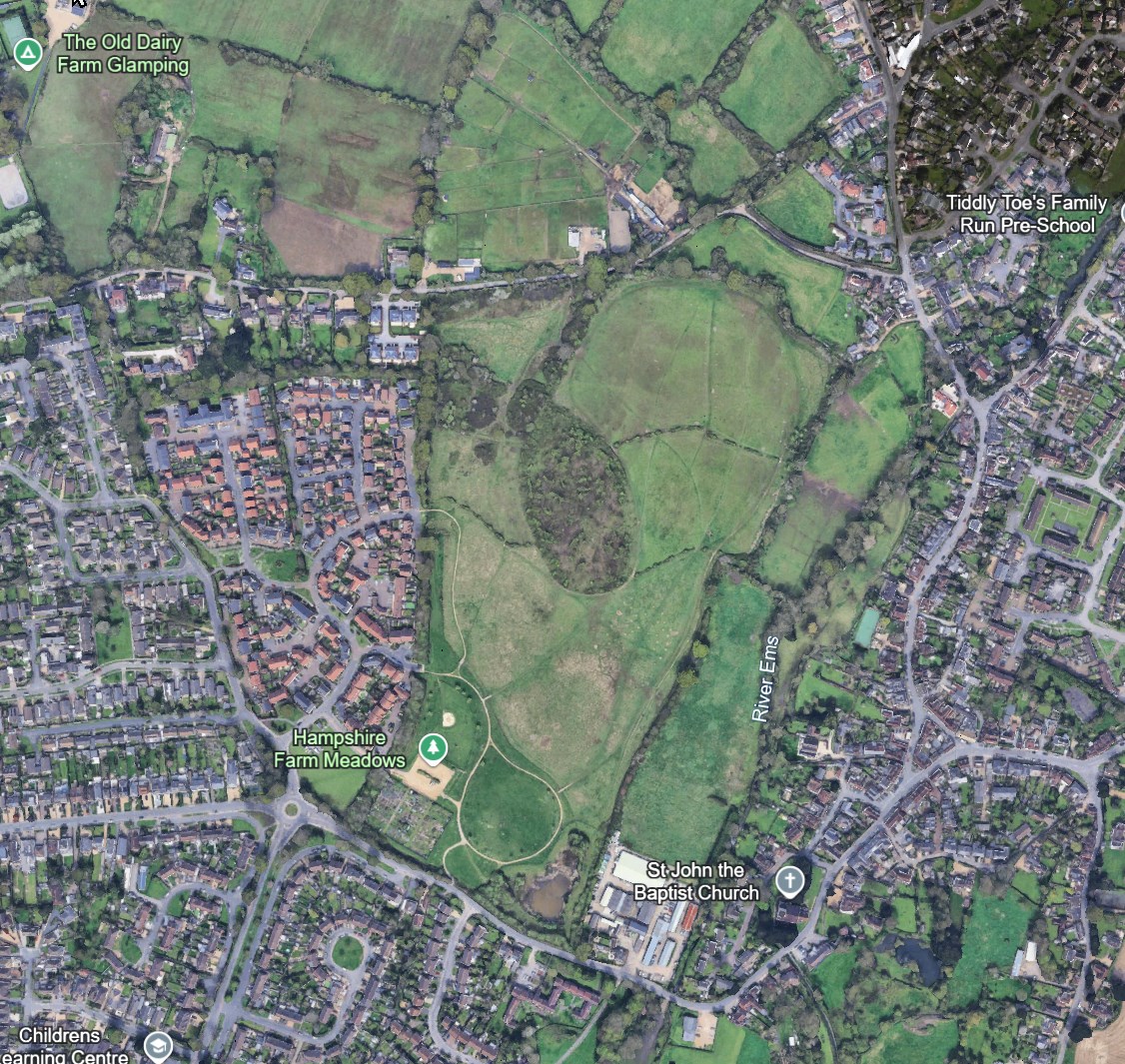
Nice find. I’ve had a quick look on Google Maps and there is an alternative parking area - looks like a public car park with plenty of space off Redlands Lane / Skylark Avenue down by the allotments. (Right hand edge and two-thirds down in your picture). If no-one objects to a few drones it could makle a decent place for a meet or two. We would need to be on best behaviour. there’s a childrens’ play area (Bottom right corner of picture) close to the car park and a school and a church within 500 metre radius. Plenty of open space northwards though
This site is also near (in terms of airmiles) a small airport located at ThorneyIsland, marked as a Yellow Zone warning for Microlights as follows
Ultra Lights
THORNEY ISLAND MICROLIGHT SITE
Summary
Yellow zones indicate regions where operation of your drone may raise security, privacy or safety concerns.
Vertical limits
This piece of airspace is in effect above Surface
Remarks
Site elevation: 3 FT AMSL.
Increased risk for drone operations
There is an increased risk of encountering aerial vehicles at this location.
Although this site is outside of the Airport Yellow Zone, it is nevertheless in the flight path of the airport with x1 runaway actually facing Hampshire Farm Meadows.
Extra Vigilance for Microlight and/or low flying Aircraft would therefore be all the more of an advisable and prudent step to take prior to take off as well as during drone flights taking place in this location.
Don’t fret too much. The Microlight site is occasional use only, mainly weekends and the yellow zone is advisory only.
There are three runways at tThorney - it was an RAF base before decommissioning, used as housing for asylum seekers before becoming home to two RA regiments - drop shorts and cloud punchers
The runways are marked each end with large white X’s they are not in use for general aviation although the microlights use part of them or the grass depending on convenience.
More worrying with Thorney is the TOAL of military helicopters at times - often nighttime. Heavy stuff like Chinooks and Ospreys. One of the RA regiments is experimenting with anti-drone measures from time to time. Their activities are subject to NOTAM.
The Red Arrows NOTAM covers much of the south and is active at various times on Thursday and Sunday. Again it is advisory.
It’s the first time I have come across dronecloud. It has some of the information that our own Drone Scene has!
Thanks, macspite for the additional info which is interesting and useful to know.
I’m not local or very familiar with the site, but want to visit for a flight, so my brief research of it, following your recommendation, just relied on the collated info I gathered online and on App.Dronecloud, all of which I shared here with you.
Ref - Thorney Island
Interesting to learn from you that the airport is RAF decommissioned now, which might explain why it isn’t Red zoned. It might also therefore be a good spot for a drone flight, when not in use or if now marginally only used by microlights occasionally. It does appear to be quite a vast area on Gmaps. Have you flown there yet and if so can you share your findings (access, parking, etc) and if you experienced any objections from anyone there?
TOAL of military helicopters - Good to know, thanks. It will obviously be red zoned when in use by Military for aviation. It will be interesting to know if drone flights can take there or in the vicinity outside of those schedules which as you say will be NOTAM.
Red Arrow Notam days
Very useful to know the days – thanks!
Ref - App.Drone Cloud
Yes, it is very similar to Drone Assist. I use it just as a backup when my Drone Assist is struggling with weak signal, as App.Dronecloud is a bit lighter and therefore map loads quicker. It’s an online app that loads in html as a webpage so if you save it’s url to your home screen on your phone, it will load in one click, pretty quickly.
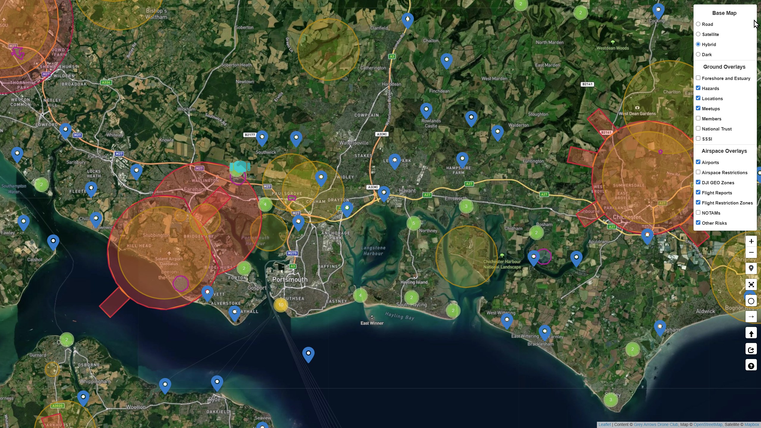
Have you tried Drone Scene which does the same and much more. It is part of Grey Arrows, continually developed by the same team that run GADC. Click the hamburger icon next to your avatar at the top of the page and then click dronescene
As a gold or silver member you have full access to it. It also can be save as a home screen url.
As well as aerial hazards, updated in real time (it uses the same datasets as dronecloud and Altitude Angel) it has layers showing Crown Estate property (good for drone flying) National Trust and English Heritage sites, contact numbers and information for FRZ and similar, links to bylaws in various local authorities …
The screenshot above shows the layers menu opened with some switched off, the forthcoming FortNelson meetup (tonight!) and a fair number of blue markers and green circles.
Those markers are sites that people have flown and, like the Hampshire meadows info above, taken the time to describe the site, access, parking and any amenties so others can fly there in future. The green dots are clusters of flying sites that will reolve into separate blue markers as the map is zoomed.
It’s a mystery to me why people ignore this in favour of less useful apps!
Yes, as a newbie to this club, I haven’t long had access to DroneScene. I fully intend to use DroneScene as soon as I have familiarised myself better with all its features beforehand, so flight time is not wasted doing this on locations.
I primarily use DroneAssist only because it is the first one I learnt, but I have found it does struggle a bit to load maps (on my phone at least) when in remote rural areas. When this is the case, I use APP.droncloud for its loading speed alone, when I only want to know what flight restrictions or cautions may be in place before I fly.
Notwithstanding, I’m looking forward to using DroneScene properly, as soon as I know my way around the application enough to be able to use it on location efficiently. I’m nearly there!! I do love the fact that it shows sites other people have flown. That is a great feature, in addition to everything else it offers.