given its available in the other app it isnt a feature I need… Feel free to suggest it …
Anything to stop the free advertising of other apps.
Menu at top right, “Flight Reports”.
2 Likes
Here’s what I see for my local Class D CTR on Drone Scene, so I’m not sure why you’re seeing so little:

1 Like
Unfair comparison, they’re zoomed in so far on DS thats how it will show, maybe that is the point they are making ?
i zoomed out … still showed the same … the zoom when you click on your location goes in far too far …to be usable i have to unzoom 5x
Logging a flight can be done but it links to DA/Guardian with your account there …
Whilst some here may not like the fact that I find GA/DA easier and better to use than DS for THIS ASPECT saying its not useful is just wrong.
I like DS i just prefer the other apps to it when it comes to flight logging etc…
i think all the pertinent details are out there now for folks to decide what they want to use … i’m done on it…
1 Like

The zoom and scroll of DS is not the best but it has the best data set of all the available apps.
It not only has places you can’t fly but areas where you can.
It would be cool if it could be made in to a mobile app but understand that you don’t get that for free and it is already a better product considering.
1 Like
Hi @Gkinghrn - I need to answer some of your posts and feedback please, as some of it is not quite true / accurate ![]()
I was quite confused when you said this:
And:
Again, I was confused here because Drone Scene does tell you all you need to know. Puzzling ![]()
It wasn’t until I saw your screen shots a few posts down that I then understood what you were doing wrong and the penny dropped ![]()
Your screens shots are not comparing like-for-like data sets. You’re comparing two very different data sources / data layers.
Here’s the examples you gave:
and

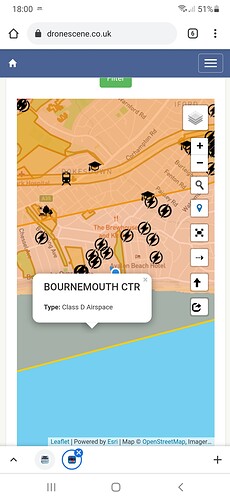
What you’ve done here is compare a DJI GEO zone, to a NATS airspace layer ![]()
(something you can’t do in any other app, they don’t have DJI layers)
Take a look at my layers selection list on this example and I’ve only turned on the DJI GEO layer and as you rightly say, it only says “Class D Airspace” - because that’s all DJI tell us for that zone.

If I change my layers to use the NATS data set, we get a very different story when clicking on the same area. Look how much information is now available to you:

So hopefully that clears the confusion and provides you some reassurance ![]()
For some of your other feedback:
As @kvetner said, it’s in the menu bar, under Flight Reports.
Here, we allow you to connect directly to your existing NATS flight report account.
Once connected you can post new flight reports and also view your old flight reports too:

With regards to the zoom level when pressing the Location button:
That’s great feedback, and to my knowledge you’re the first person to mention this.
The NATS app doesn’t zoom at all from what I recall, it just centres the map over your current location? ![]() (I may be wrong, not used it for a while)
(I may be wrong, not used it for a while)
Maybe we could add that as a setting in your preferences? Give people the option to set what zoom level they prefer when clicking locate? ![]()
I’m always happy to discuss any feature requests ![]()
And for this one:
Sorry to hear that ![]()
But don’t worry mate, we’re not offended, it’s not like we make any money from it ![]()
Besides, we can’t convert everyone ![]()
5 Likes
PS. We also have a very useful “about” page, which tells you everything you need to know about each layer.
1 Like
The ‘I am done on it’ simply referred to the thread not DS which I think is great so don’t take that the wrong way as it wasn’t intended like that.
The zoom on the Nats app is pretty good in terms of the zoom when you press the location symbol … by default it centres on somewhere near London if I recall correctly…
I had all the zones ticked on the Layers as that’s the default I assume.

There’s other features in DS you don’t find elsewhere, at least not in one place. Like the ability to measure distances to check if you’re not flying too close to built up areas, roads, railways, etc.
It also includes the National Trust dataset, you won’t find that in any of the other apps and it’s a significant dataset.
Finally, as mentioned several times recently, they listen and update the site. I asked for the measurements, it was there in a matter of days.
Whatever you think wrong with DS, keep coming back to see how much they listen.
2 Likes
I don’t think anything is wrong with it …it’s like any other application they all are better than each other in 1 way or another …
Sorry if I find another app easier to use  in some respects …
But I will try to use it more once I put the web link on my Home Screen on my phone …
1 Like
Dronescene will open with the layers you had previously selected the next time you use it. I tend to fly in the same location so all I need are the NOTAM and Flight reports layers active so I can do a final check before I go - the local Royal Artillery base jas the occasional drone jamming exercise.
1 Like
So behaviours i notice with both products.
-
I open Guardian …the map appears it then goes automatically to my location at a zoom level that shows maybe 20 miles max on screen which I find is perfect.
-
I open DS - I just get the full map of the U.K. with a location pin dead centre of U.K. . I click the location pin icon amd it zooms in to where I am …I press the unzoom 10x to get it to a size that’s usable for me.
So is there a setting which should be in DS to just at least go to my location on startup or is that the expected behaviour?
Yup, that’s the default behaviour.
The reasoning behind this is quite a simple one. Drone Scene is primarily a map of recommended locations to fly your drone.
The additional layers of data are secondary to that primary purpose ![]()
Our assumption is (was?) that people come to Drone Scene to look for places to fly their drone.
However, as a few people have mentioned above, unlike any other drone related app you can find, Drone Scene is a continually developed product and has expanded waaayyyyyy beyond what it was just three years ago.
No other drone app has ever expanded beyond their initial release.
As Chris recently pointed out elsewhere recently, DS is quite literally built by drone pilots, for drone pilots.
Point in case, if it wasn’t for @kvetner and @milkmanchris (and an entire army of our Advanced Members that volunteered to become Beta Testers) the entire Good 2 Go module wouldn’t even exist. No other app on the planet has this tool ![]()
The feature-expansion of Drone Scene is 100% based on GADC member feedback, suggestions, complaints and recommendations. All the while our members continue to make suggestions and recommendations, all the while our members provide feedback on what they like and what they don’t like, all the while I will continue to sink hundreds and hundreds of hours of my own time in to the development of it in order to make it better for everyone here.
You’re not alone, Gordon, in asking for it to become a native iOS and Android app. A few people have requested that now.
Cards on the table here mate, I am not a mobile app developer.
Because of that, I’ve yet to find an app development company that can provide me a quote for under thirty grand to built two native apps (one for each mobile operating system). Yeah, I know there are build-once-deploy-to-many-platforms frameworks out there like Xamarin, Ionic, etc, but ask anyone who’s ever used one and they’ll tell you it’s a serious sacrifice. Cross platform builders simply can’t give you the truly native experience, something is always compromised. And we don’t want to give people a poor user experience, we’re here to make your lives easier and better.
Much as I love you guys, I simply don’t have £30k+ to drop on an app that quite frankly can’t do anything that the web version can’t ![]()
Anyway, I think we’ve explored all avenues of this conversation now so I’ll wrap up here ![]()
If you have suggestions for improvement, as this entire thread has already demonstrated, not only will we listen but we’ll actually build those features for you. Again, NO other app will offer you that level of (free) customer service.
So please (everyone!), do keep the feature requests coming.
10 Likes
I can well imagine the effort that’s gone into it as I am an old developer myself .
I am not at all critical of it so don’t read that into anything I am saying.
I also don’t need it be developed into a full blown app …providing it’s got a responsive design (which it has) then I would agree you don’t need it to be an app.
All I have done is point out some differences …I don’t believe I’ve been critical of it …
2 Likes
If people keep joining fingers crossed you’ll eventually get an app developer with a love of drones 
Wish I’d have kept up the coding would have been a great little project.
Alternative is that NATS approach you when they realise how superior it is to their own
2 Likes
Awwww shucks ![]()
But in all honesty you guys wouldn’t want that. If they were to get involved it’d only get updated once every three years and that update would only contain bug fixes and no new features ![]()
6 Likes
Please keep it as a web app, instant updates, quick fixes, etc 
3 Likes