Speaking of sausages, there’s an excellent sausage shop in Clitheroe.
11 posts were merged into an existing topic: Maps & Compasses, Sextants & Chronometers - All About Navigation
This may be of use to anyone in the affected areas:
- B0254/26: Restricted area : miscellaneous plain language
Q) EGXX/QRRXX/IV/BO/W/000/010/5218N01451W999
THE FOLLOWING UAS RESTRICTED AREAS HAVE BEEN REMOVED FROM THE AIP
WEF 19 FEBRUARY 2026
EGRU185 NSA BOSCOMBE DOWN
EGRU268 NSA BRIZE NORTON
EGRU354 NSA CONINGSBY
EGRU707 NSA KYLE OF LOCHALSH
EGRU708 NSA LOSSIEMOUTH
EGRU276 NSA MARHAM
EGRU280 NSA PONTRILAS
ERGU356 NSA WADDINGTON
UK AIP ENR 5.1 REFERS.
LOWER: Surface
UPPER: 1,000 Feet AMSL
FROM: 05 Feb 2026 17:01 GMT
TO: Permanent
Because they are being replaced by : New legislation droped by the CAA, military sites
3 Likes
NOTAM: GNSS(GPS) SIGNAL JAMMING. JAMMERS LOCATED 523033N 0015305W (ASTON, WEST MIDLANDS). ACTIVITY MAY AFFECT ACFT WI 7NM SFC TO 36900FT AMSL OR ABOVE (ALL DIRECTIONS). MAY ALSO AFFECT AIRBORNE ELECTRONIC SITUATIONAL AWARENESS DEVICES AND UAS CONTROL. GNSS(GPS) RECEIVERS MAY SUFFER INTERMITTENT / TOTAL FAILURE OR GIVE INCORRECT POSITION INFO. FOR INFO/CEASE JAMMING 07387098277 OR 07823427514 AR-2026-409/01.
There seems a blanket of signal jamming around the west mid’s on drone scene but not sure why. Anyone had any issues flying around here lately?
I’ve still yet to read of a confirmed case of anyone’s drone being jammed anywhere in the country regarding such notifications.
2 Likes
I’d prefer to have £1 for every “GPS Jamming” NOTAM than £1m for every “GPS jamming killed my drone/car navigation/plane navigation” report.
3 Likes
Cheers, guys, I’ll give it a bash when I get there! ![]()
![]()
Or if you want more detailed info… ![]()
1 Like
Football ![]()
1 Like
Me thinks that’s a little OTT… What’s going to happen, the MRI machine goes crashing through the wall and ends up at the football ground? ![]()
Actually - if such total havoc was caused, that would be (kind of) good news … because GPS jamming would be instantly banned. ![]()
1 Like
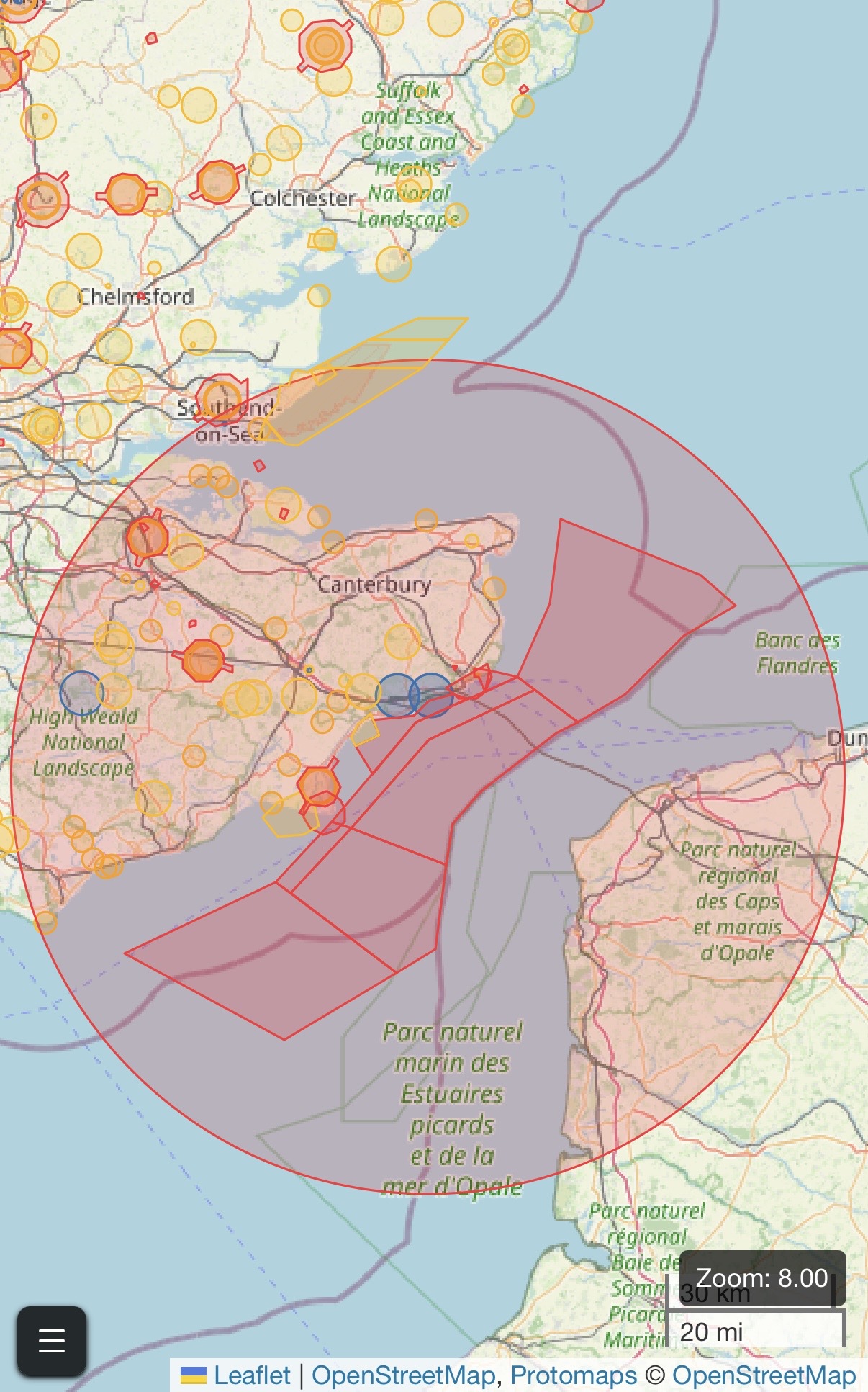
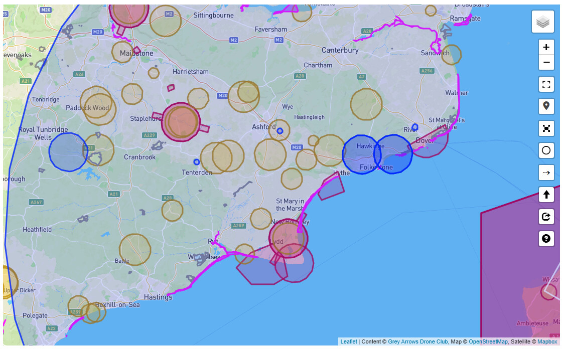
Well this appears to be a pain. Best part of Kent becomes a no fly zone for an unknown period of time, given that it implies it will be renewed on 5th March.
Anyone know why?
1 Like
Border Force Ops with a ridiculously sized radius? It certainly won’t apply to the French side.
Has someone at NATS pressed the wrong buttons?
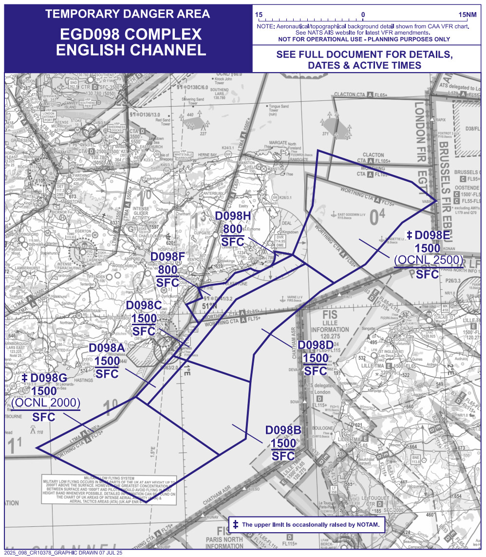
AIC Y 008/2026 appears to set out the red areas in the Channel. This map is on the back page of that AIC:
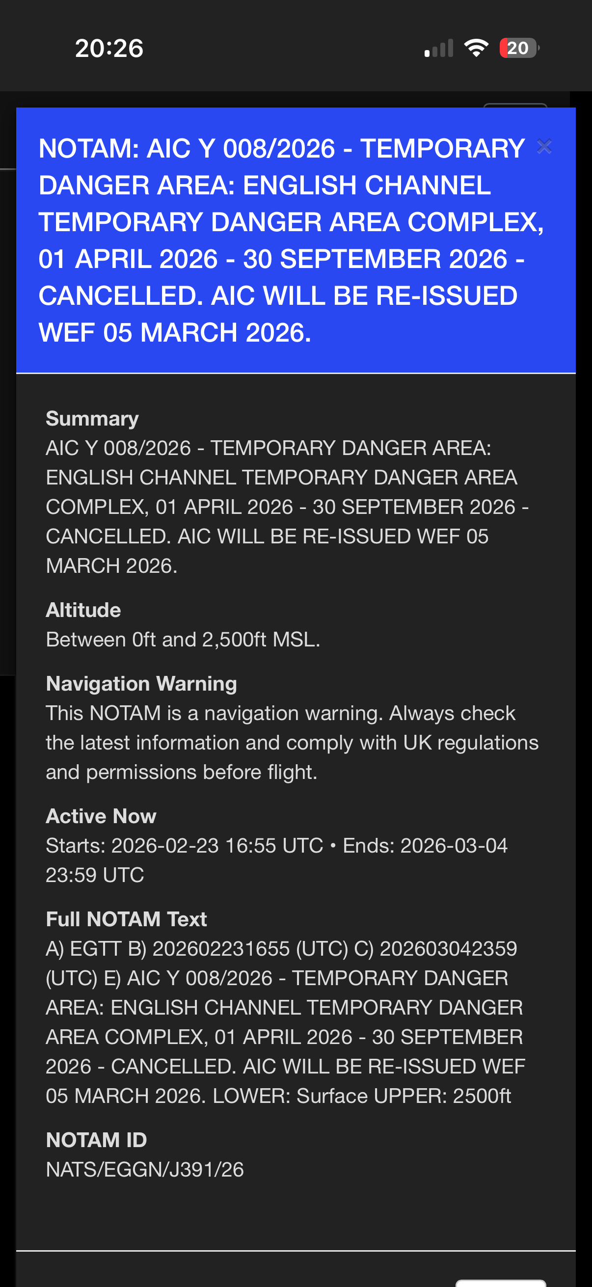
NOTAM J0114/26 seems to suggest AIC Y 008/2026 has been cancelled and will be re-issued:
AIC Y 008/2026 - TEMPORARY DANGER AREA: ENGLISH CHANNEL TEMPORARY
DANGER AREA COMPLEX, 01 APRIL 2026 - 30 SEPTEMBER 2026 - CANCELLED.
AIC WILL BE RE-ISSUED WEF 05 MARCH 2026.
So is the big red circle just trying to tell us that the red polygons in the Channel have been cancelled, rather than it being an actual TDA itself? ![]()
I’d be very surprised if they were because Border Force use a Dash-8 aircraft + drones for surveillance ops along that section of the Channel.
The AIC was setting out those TDAs from 1 April 2026 so I presume the big red circle represents the cancellation and re-issuing of those TDAs in the future. Perhaps they want to adjust them?
I presume the red polygons that are in place right now stay in force and will continue being renewed until 1 April when they will switch over to whatever the re-issued AIC says.
So, now on Drone Scene, unless I have my layers set wrongly, the EGD098 TDAs in the Channel are not shown.
The big AIC Y 008/2026 NOTAM is still there though.
Is that correct?
Other drone safety maps show the EGD098 TDAs but not the AIC Y 008/2026 NOTAM.
Hi there! Before you post, have you selected the most appropriate category for your new topic?
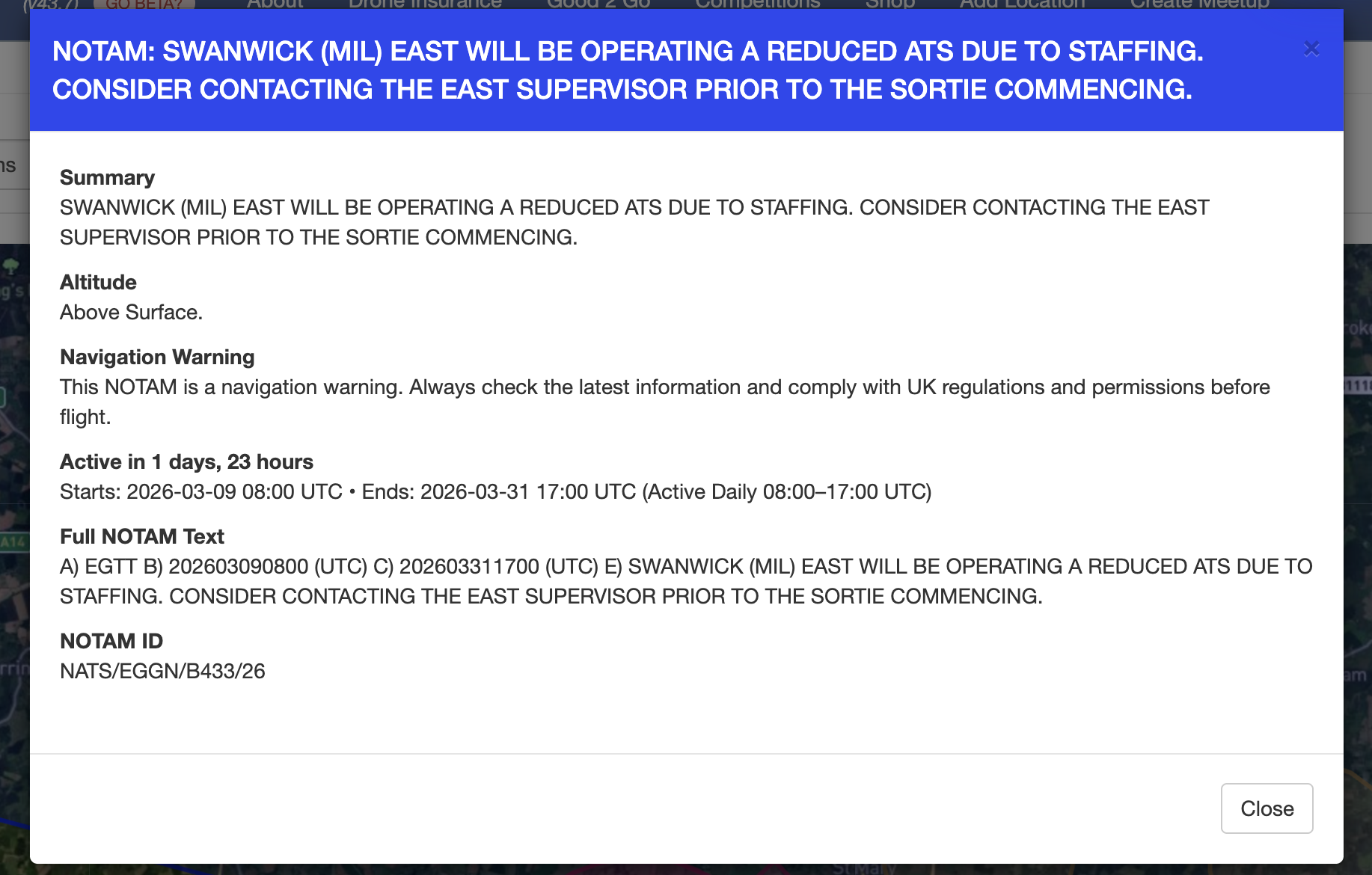
I am based in west Norfolk and It looks like there is a huge area covered by this notam from the 9th till the 31st of this month which will put pay to my flying as it seems to cover the whole of Norfolk and a good part of Suffolk and Cambridgeshire ![]() . I don’t like to travel too far at the moment as my car is a bit of a gas guzzler and it looks like people are on a fuel buying frenzy because of what’s happening abroad at the moment so I guess I will just have to suck it up .
. I don’t like to travel too far at the moment as my car is a bit of a gas guzzler and it looks like people are on a fuel buying frenzy because of what’s happening abroad at the moment so I guess I will just have to suck it up .
NOTAM ID
NATS/EGGN/B433/26