I am looking for a simple cheap software similar to a cut version of dronedeploy or pixel. purely for amateur use. Any suggestions? By the was I am not good at techy stuff.
Dave
I am looking for a simple cheap software similar to a cut version of dronedeploy or pixel. purely for amateur use. Any suggestions? By the was I am not good at techy stuff.
Dave
For what drone @Ronidog ?
@PingSpike the Mavic Air. I want look at the vegatation on a Moor over the seasons
Does the DJI GO4 app now support waypoints for the Mavic Air?
I’ve not used it for a few years, maybe it only does waypoints for the Pro range? 
Litchi also comes highly recommended (and definitely works with the Air).
You will get a lot of people recommending Litchi. I use the Android version with my Mavic Air and plan missions on rainy days using my desktop PC, test them out by virtual flying on Google Earth and go out on sunny days to fly for real. Upload the mission, set the drone off and wath the screen as it flies the preplanned route.
I’ve had no problems with it and consider the money I spent (which, at around 20 quid, seems high for an app) to be well worthwhile and probably the best accessory for my Mavic Air or for any supported drone.
I prefer Litchi to the DJI Go4 app tbh, never had a prob with Litchi but Go4 keeps crashing on me
As far as I can see the DJI GO4 app does not support the Air.
Does Litchi allow me to grid out an area and then create a flight pattern to cover the gridded area and take photos? My understanding was that you created waypoints for a flight which I think is slightly different.
Please excuse my ignorance or lack of a clear explanation of what I am trying to do. I will try again below.
I have an area of moorland I want to fly over and photograph it. in a systematic way taking linking photos. Then I want to be able to go back a few months later, fly the same mission, take the same photos and therefore have a comparison.
I’m not sure about gridding with Litchi as I’m a new pilot but it’s perfect for plotting a course and using waypoints
The Air, unless I misunderstood your intent, is very much supported by the DJI app.
As to Litchi, you can certainly do what you want and the only caveat is that for that type of mission you can only do it with straight lines / turns.
@stubbyd yes the djii app does support the air but not on waypoints.
Litchi might be the way to go. Can you sore the missions?
Not the waypoints, though, I think.
Yes. Can create on computer/laptop, too, and sync to devices.
Have a look at Litchi vs Go4 and Litchi chit-chat … What’s Litchi? Should I use Litchi? for some more info and a feel as to what can be done using Litchi.
I think your think is right. I was referring to the broader ‘does it work’ but now realise that should be seen as a given. Doh!
Thats OK I always appreciate any supportive responses to my questions
Does anyone know if you can use Litchi with the Mavic Mini, or is it not advanced enough for that?
… on second thoughts, for get that question - it’s answered here Litchi’s response to the Mavic Mini
Litchi will allow you to repeat a mission with no problem. It doesn’t (yet) have an automatic grid setup.
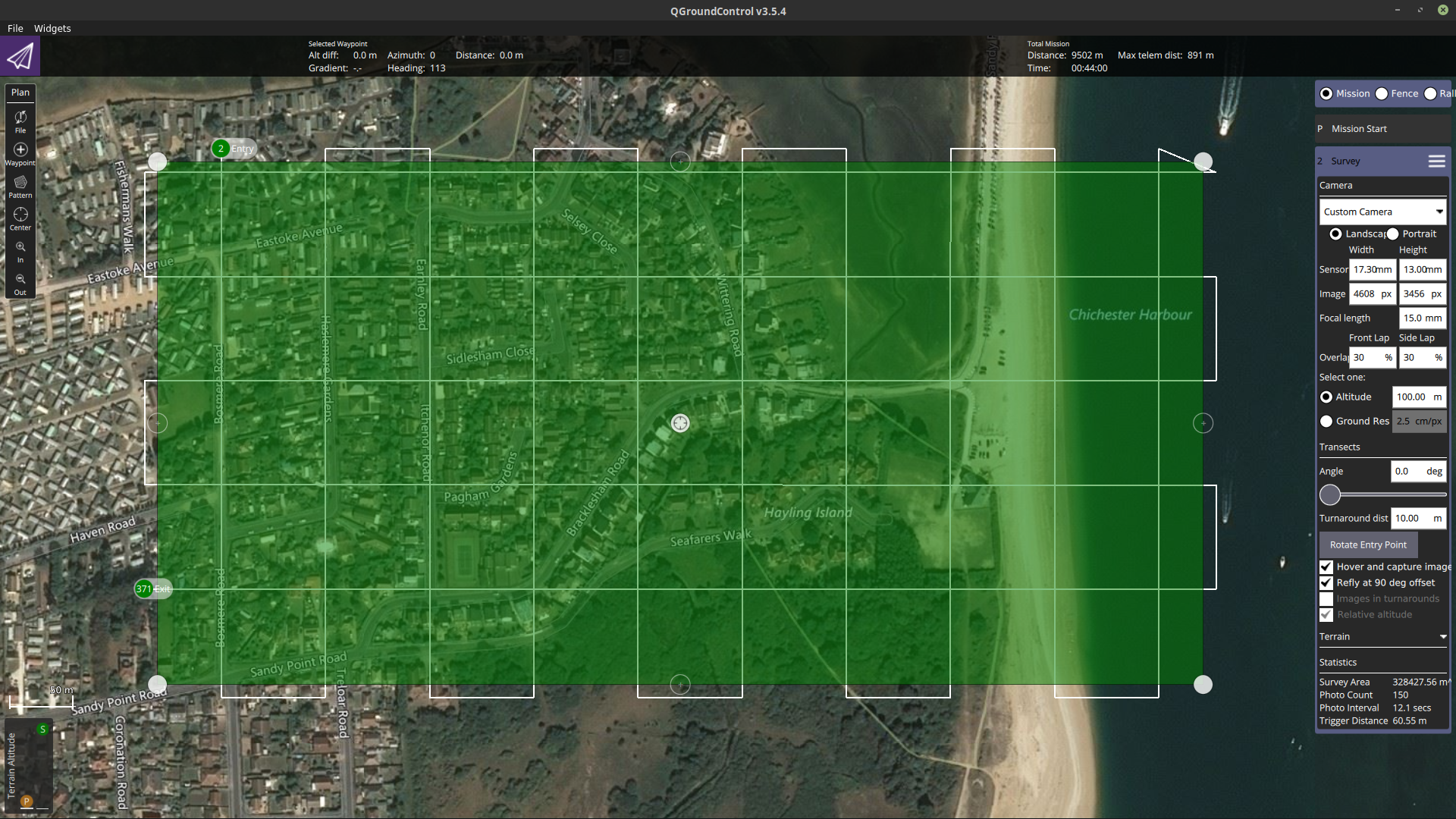
One workaround I have yet to try for real is to use QGroundControl on the desktop - it’s free software designed for PixHawk type controllers.
Set up your mission - it allows you to set area, height, pattern, photo overlap, focal length and sensor size and will then calculate each point where a phot should be taken.
So this is a mission using an Inspire with an X5 using the standard 15mm lens with a 30% overlap and an up and down pattern. Shame the Inspire uses a DJI flight controller and noot a Pixhawk ![]()
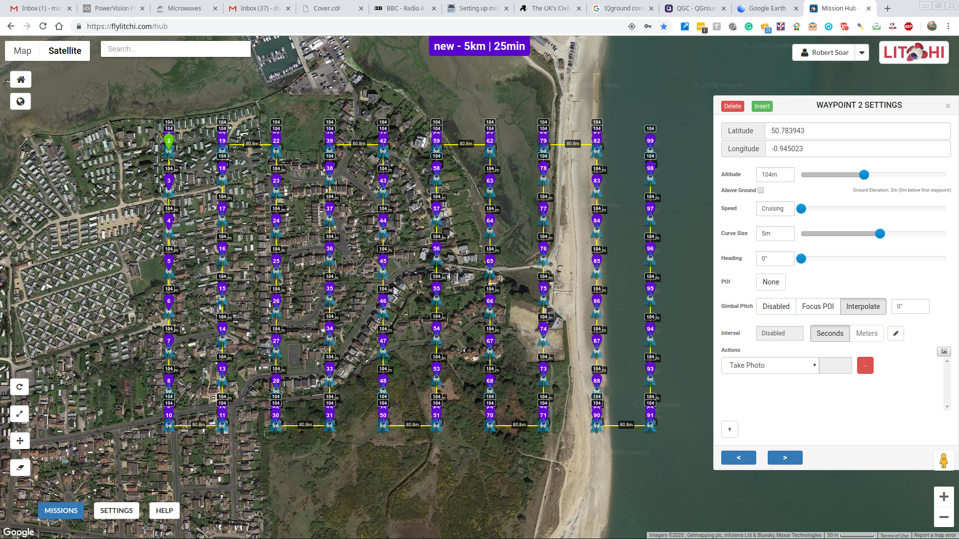
But - if I save the mission as a *.kml file I can view it in Google Earth and, more importantly, import it into the Litchi Mission planner. Tick the box for the take photo at waypoint option and you now have a search pattern with a photo taken at each waypoint. The only thing I’ve not found yet is a means to set default gimbal angle to minus ninety degrees.
I played around with this when I was asked to map a field for a planning protest (no payment offered or sought!) but then found out all that was wanted was a few oblique snaps so I haven’t tried it out for real. But you have converted a QGroundControl mission to Litchi, keeping all the waypoint data, just need to change each waypoint gimbal direction to -90.
Worth playing with - I’ll try it out sometime soon ![]()
You can use the DroneDeploy and Pix4d software to do the actual flying for free. Personally I prefer DroneDeploy simply because you can plan everythin on a PC and then it uploads to the monitor ready to use with the drone.
If you are looking for software to do the processing of the images then the only one I know of which I,m playing with id WebODM.
The version of DD I have allows me to plan, much the same as the free QGroundControl:
Unfortunately, when trying to upload the mission this appears:
Which is why I went the QGroundControl planning and import into Litchi route ![]()
You should only get that if you try to upload the images to DD.
I’ve done a couple of flights in the last few days using preplanned missions on the PC. These have synced automatically with the tablet used for flying.
Nice to know there is an alternative though.