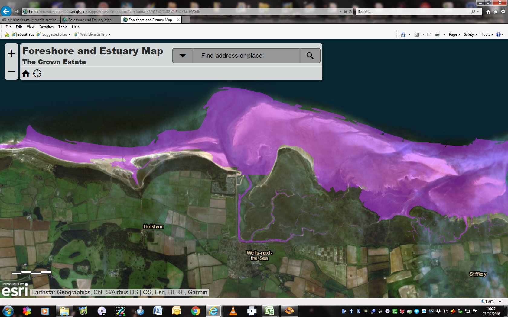
Am I correct in assuming that the Purple area around the coastline of the UK (as shown above), is the area that we are permitted to fly in !.
I ask, as Myself @PaperCrane and @UnluckyTimmeh! were ejected from an area on the above Map, when Low water was in being ,at the time.
It’s not something everyone HERE knows … I was unaware until someone posted this info earlier this year. So highly unlikely that anyone without a specific interest in the rule would be aware.
If that, or similar places, are your intended place to launch - worth having the relevant supporting information bookmarked on your phone.
A Gentleman who works for “The Holkham Estate”.
He claimed that we were not allowed to fly drones on the beach, and, we were also told by someone earlier in the day “If you take your drone down there ,they will confiscate it” (They are welcome to try!)
(I should also add we were at least 200 yds from anybody), and only 50 from the rising water line.
I personally think he was wrong, but, I did not have the relevant paperwork to prove it.
You can be bloody sure I will next time !!
The Holkham Estate have a strict Photography and Drone policy.
Which, looking at it would never stand in a court of Law ,if challenged !.
It means that technically, if you take a photo on the beach, its copyright belongs to them, and, they can freely use YOUR photo on their website !!
Yeah Right !! holkham-drone-policy.pdf (68.9 KB)
We grant permission for UAD flights over Crown Estate foreshore (defined as the land between mean high water and mean low water).
This permission is subject to all operators complying with the applicable laws, statutes, regulations and codes, as well as the requirements of The Civil Aviation Authority, and obtaining any other necessary consents for the operation of UADs.
On occasions, third parties such as Government agencies or local authorities may restrict the flying of UAD’s on Crown Estate land. We therefore recommend checking with the appropriate authority to ensure that no such restrictions are in place.
To find out which areas of foreshore we own, please use our Foreshore and Estuary Ownership Map.
So they’re saying that the land between low water and high water belongs to them. Think the Queen should be informed, this is tant amount to treason !!!
Yup!, the land DEFINITELY belongs to The Crown Estates !
He claimed that The Queen had given Holkham Hall Estate the right to look after the land !
NOT ACCORDING TO THE ABOVE MAP !!!
Will not do for him to Puff smoke up my arse next time, I can tell you !.
I fully intend now, to take any relevant documentation with me, and a crown estates print of the Map Area that I am flying in !.
And, I strongly recommend ANY member here to do the same, in areas they intend to fly.
Even NATS does not show it as a no go area !
AND, If he/they wish to pursue the matter, I will insist he calls the Police if he has any argument !
Ummm … they MAY have been given the right to “look after it”
The map is only what belongs to the Crown Estate.
You have answered the burning question !
What belongs to them !
Still means, I have the right to fly !
AGAIN, I quote:
We grant permission for UAD flights over Crown Estate foreshore (defined as the land between mean high water and mean low water).
I would say a Solicitor would have them laughed out of Court, should they pursued the matter !
I agree, to a point, but, where do they stipulate over/on their land/estate on there own website for Holkham, It stilll does not cover Low water land (at the Low water mark.)
Looking at the map, they only own part of the beach (at high water)
If you knew Wells (as well as I do) then the law is an ass !.
I am so enraged by this stupid grey area I fully intend to speak to the other half, to get her boss to look at it ! (he is a Barrister)
Is it worth writing to the estate to get their official line given what the Crown Estates “permission” implies? Quoting the CE statement might at least prompt the estate to explain their no fly policy…
The estate ie Holkham say that the want payment for Any photography or drone images once approval has been granted that is
As ever photography is being short changed again
If anybody tries to eject you from Crown Estate land or confiscate equipment, call the police. They have a well informed drone department in most forces now and will clarify to the adjacent landowner!
The map is a mess, such as the wording saying it excludes rivers, then the map shows almost all of the river severn as being flyable, yet great swathes of the estuary as not being available
like all things created for officialdom by it’s minions, it is deliberately as clear as mud
Thank you @SkyJumper for your post on “The Crown Estates” information.
We have had the new links amended accordingly in my original post and in the
“GADC Drone Information Pack”.
Thank you once again for your update.