Hi I’m new so bare with me but I’m just wondering when do I need permission to fly my drone from the faa or caa
FAA is America - probably never.
CAA is UK - for commercial work.
Permission to fly in FRZs (Flight Restriction Zones) is obtained from the related airport’s Air Traffic Control.
But you’ll probably never need it - since no-one usually needs to fly that close to an airport.
Never from the FAA cos they are in the USA.
Never really from the CAA if you are a hobbyist. Just follow the drone code.
If you are wanting to fly near an airport (a NFZ) No Fly Zone. Then it’s permission from ATC (air traffic control) you need.
The CAA only make and investigate rules contravention, they are not really interested in permissions.
They do regulate permissions for commercial operations (PFCO) but unless you are a business making money from drone photographs, then I wouldn’t lose any sleep.
As long as you are following the drone code, you can fly at will.
Thanks Dave so with me only flying for a hobby I don’t need to worrie as long as I stick to the drone code
That’s pretty much it.
If you haven’t, download an app called Drone Assist - this will show any temporary No Fly Zones (Donald Trump visiting Portsmouth - demolition of power station cooling towers - air shows - etc.)
When you install it, switch off the Class D Airspace in the settings …
- it’s everywhere, pretty much, and
- it doesn’t affect us below 400ft.
Thanks guys for clearing that up for me 
One other thing if im only a hobbyist can I put my photos and video clips on here or is that only allowed for those who are commercial
This.
This is the best advice you’ll get all day. Check that app before any flight and you’ll be mostly OK. Its airshow season so restrictions can pop up from time to time.
Oh, and stick to the drone code.
You are absolutely free to put them anywhere - provided that, when you undertook the flight, there wasn’t any intention to receive money/benefit/etc as a result of that flight or from the videos/photos taken during it.
One additional note on Drone Assist …. the initial map may show forthcoming restrictions that may not apply on the day you are flying.
Clicking on a location you intend to fly will display a list of all current AND forthcoming restrictions.
If you want to check what’s active that day - click the report button at the top and it will list them.
Clicking on any of the reported events will give you the dates/hours between which a restriction is active.
Drone assist is that the nats app
Yes.
Iv already have the app but I don’t think I turned off the class D airspace so how could I check
By going into settings and switching that item off.
… and switch off Upper Airspace, too.
Just gone into settings do I click on reset application
Reset sets them to a default on/off combo.
Just switch off the switches next to Upper Airspace and Class D.
On of them is under Advanced Settings.
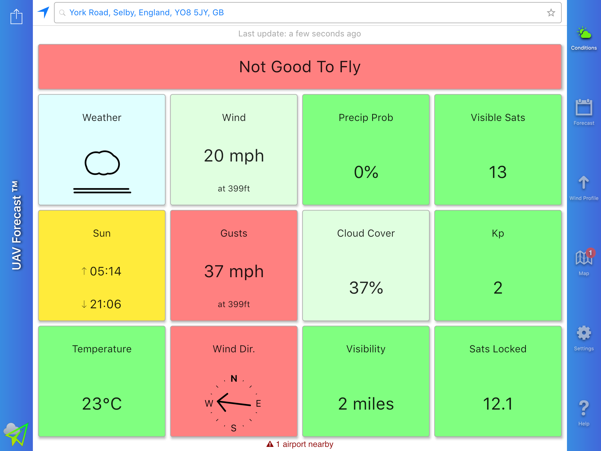
Drone assist is the NATs app, you might also find useful the UAV forecast app, it’s free and gives you the conditions of wind, rain, sun, etc etc. Just don’t forget to set the parameters in settings or it’ll be telling you it’s not good to fly all the time. I have mine wind limit set at 22mph at 399 feet, because it can be windier aloft than on the ground.

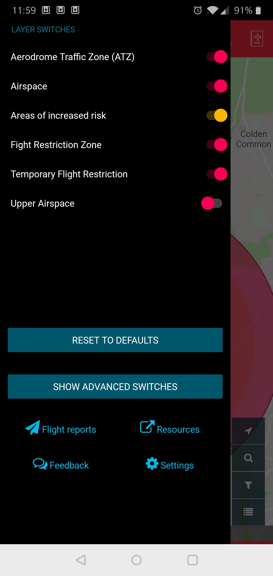

My layer switches
Airspace that is turned on
Areas in increased risk that’s turned on
Ground hazards that’s turned on
Upper airspace thats turned off
Is this all correct ?
As per the screenshots above.