At the end of July we announced a massive overhaul of our Drone Scene web site.
There wasn’t tooooo much wrong with the old DS site but it was starting to look a little dated and we were having some issues in keeping it up and running so we rebuilt the entire site from scratch and added a whole bunch of new features at the same time.
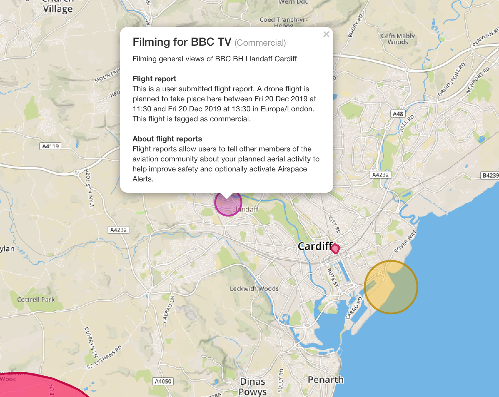
One of those key features was the ability for Drone Scene to display an additional layer of data, that of Flight Restriction Zones. As the rules around where we can fly are constantly changing, this was a great addition.
However, no sooner had we launched Drone Scene v2 than work began on Version 3 ![]()
And today we are pleased to unveil Drone Scene v3:
Drone Scene v3 brings something rather special ![]()
Rather than just a ‘static’ layer of FRZs we’ve gone one further. Well, we’ve gone way more than one further…
And it’s not just a layer of flight restriction zones, oh no ![]()
Drone Scene now offers you a multitude of layers, all live, all updated in real-time ![]()
![]()
The new interactive layers include Airports, Airspace Restrictions, FRZs, Temporary-FRZs, NFZs, Heli-routes, Ground Hazards (eg. electricity pylons), optional Class D airspace, Flight Reports submitted by drone operators using the NATS app, and other Flight Risks (eg. HIRTAs, Schools, etc).
Think of the NATS app - but good.

Oh, and for good measure we also added Weather data too, which provides the current weather and the forecasted weather at the location you’re zoomed in to ![]()
And the current KP Index is available now too!
Again, all updated in real-time ![]()
Looks good, right?
Well, those looks come at a cost…
We very much feel this is a premium service.
Therefore, all of these additional layers are only available to Grey Arrows Drone Club members.
Random members of the public using Drone Scene will only have access to the Location markers ![]()
The new features continue to roll in with v3 too as the eagle-eyed amongst you will also notice that we didn’t stop at adding a whole bunch of new layers either, oh no!
We also added a new “Share” feature too! You can now share map locations (and zoom levels!) with other people by simply copying and pasting a very unique URL that’s generated on the fly, just for you.
Here’s an example of a shared map location: Where can I fly my drone in the UK? - Drone Scene
Looking for other more subtle changes? You’ll also notice a new “Full Screen” button too, ideal for browsing the map in more detail.
We also made it easier for you too add a location to the map too. You can now simply click on the map to drop a pin on the location you want to add, rather than having to drag the marker to where you want it (but you can still drag it, should you wish).
When adding a location you’ll now also be asked to provide the land owner permission status from a drop down list of:
- Land owner permission obtained
- Land owner permission not required
- Land owner permission requirements unknown
(all existing DS locations have been marked as ‘permission requirements unknown’ for obvious reasons)
We have also added a “Permission Filter”. This allows you to filter the Location marker pins not only by Region or Category, but also now by land owner permission type too!
Regulations are changing all the time with new flight restriction zones being brought in to play earlier this year. With this in mind, some of the older recommended locations to fly may now fall foul of the now-current regulations. Therefore you may see a recommended pin on the map which is now inside a NFZ or FRZ. So a timely reminder that it remains the responsibility of any pilot to check for any changes before flying the same location.
Elsewhere, those of you who are using the luscious Dark Mode on Apple devices will also be in for a treat as the Drone Scene site will automatically detect that your device is in Dark Mode and will change it’s entire colour palette to suit. Here’s how it looks in compatible devices:

Last but not least, in order to make all your lives easier we have built in support for Cookie-based logins too, so you’ll only ever need to log in once and it’ll remember you on all your future visits ![]()
We hope you enjoy Drone Scene v3!
Don’t forget, in order to log in to the Drone Scene site do NOT enter any passwords. All you need to enter are your Grey Arrows Drone Club username and the email address you registered here with.