A new version of Drone Scene has been released 
(Missed the October update? Take a look here!)
What’s new in the January 2025 update? 
Read on!
(Missed the October update? Take a look here!)
New Feature
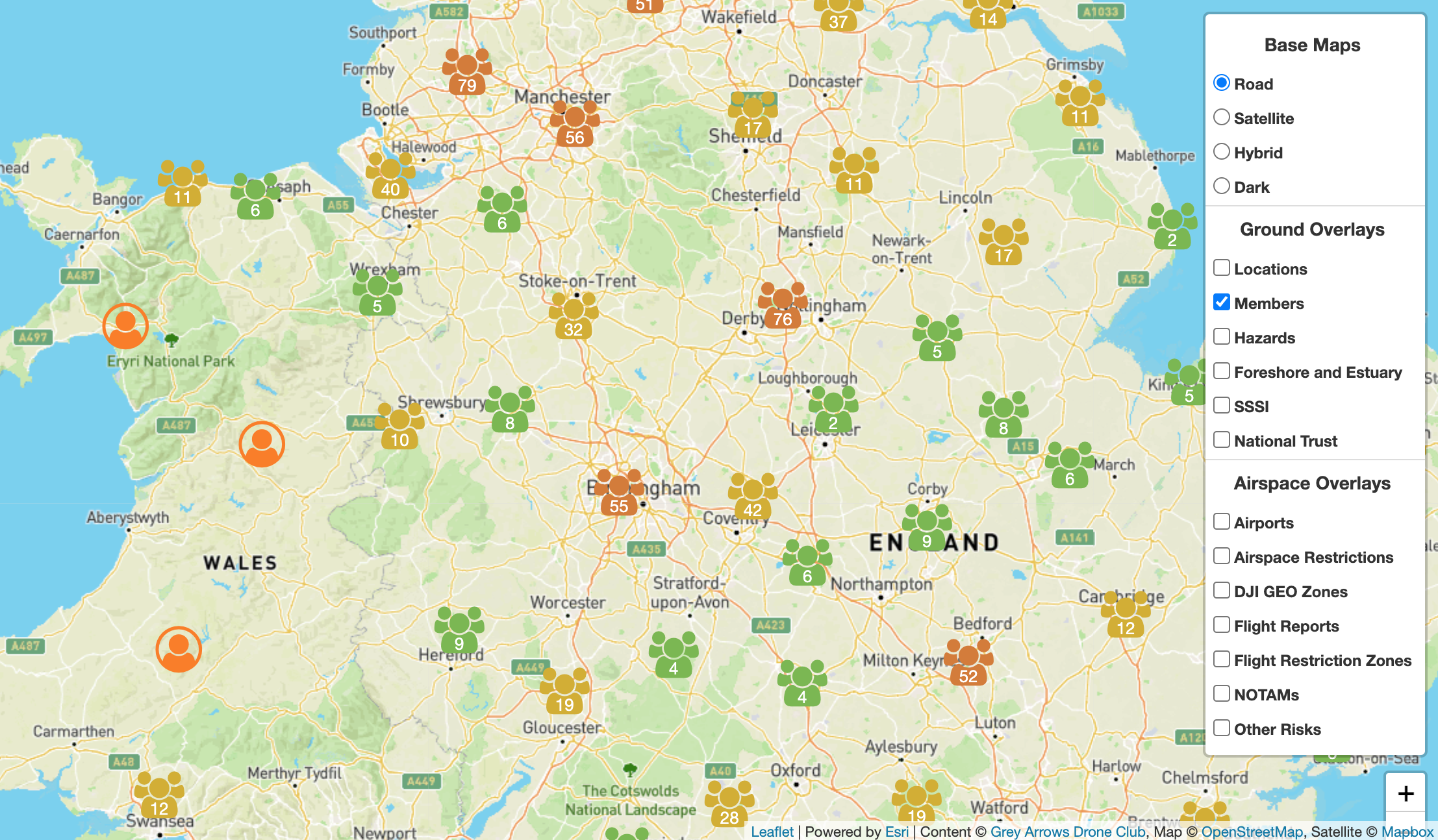
We have created a brand new layer of data which allows you to see where our club members are based.
This is really useful if you’re interested in who lives near you. It’s also really useful if you’re organising a Meetup as you can see who lives near the meet and @tag them when creating the meet so they’ll get notified.
Clicking on any member will display a summary of their profile with a link to view their full profile.
To add yourself to the map, simply edit your Drone Scene profile and click on the green Add button:
Then simply drop the person marker pin on your location and click Save:
In order to protect the privacy of our members, this layer is opt-in only. Your location marker is only visible to other club members, it is not available to the general public or to search engines.
For privacy and safety, we recommend not placing the marker directly on your exact location.
FYI, we have imported all existing location markers from the old “Members Map” on our discussion forum. If you had a location marker on the forum you may wish to review or edit it on Drone Scene to update it.
More information on how to Add / Edit / Remove your location marker on the map is available in this dedicated thread:
New Feature
– Requested by @MTLakes @clinkadink @milkmanchris @OzoneVibe @Ritish
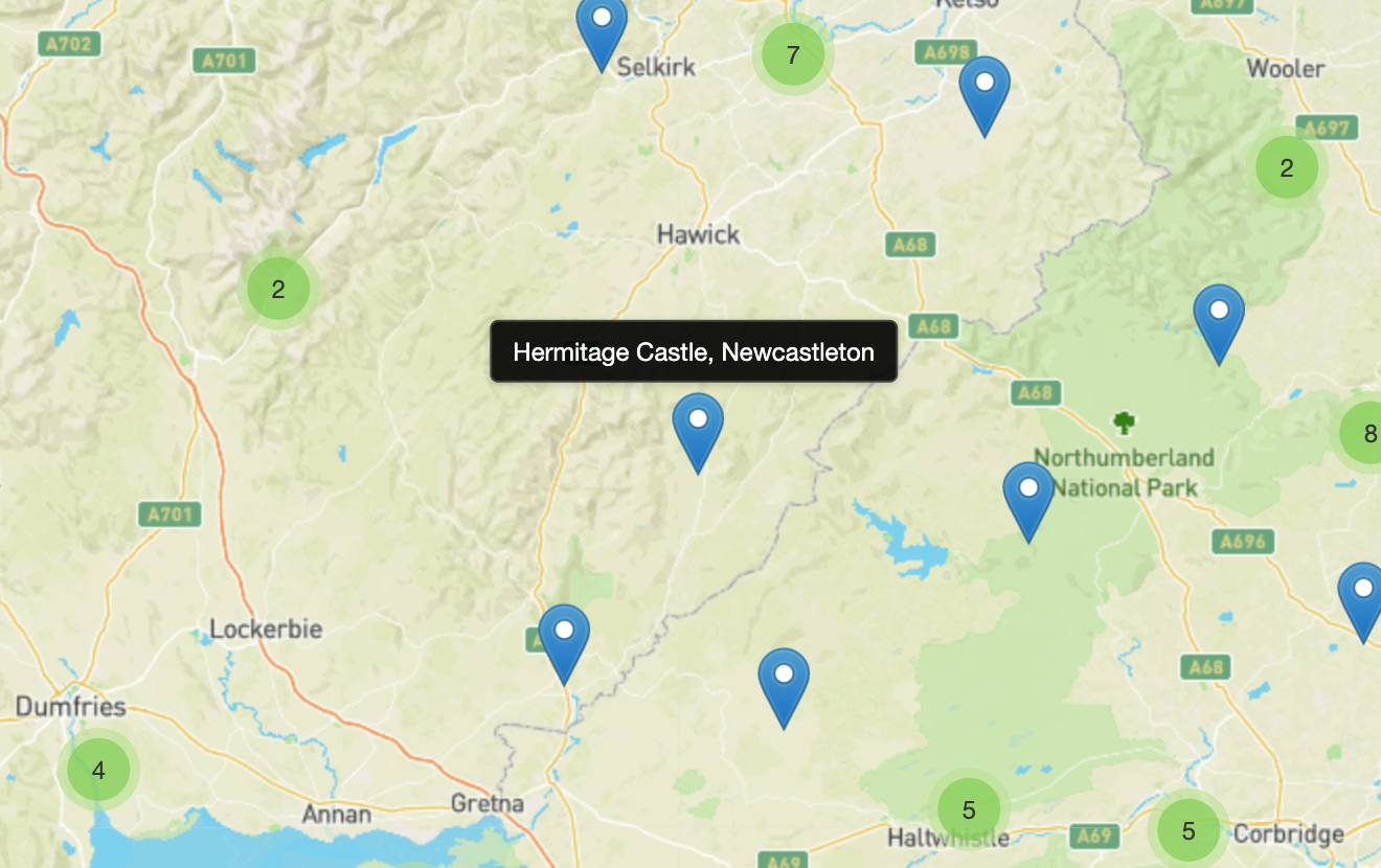
We’ve added a new Circle Tool to the list of map tools!
Click once on the Circle Tool icon to turn it on, then simply click anywhere on the map.
As if by magic, a circle will appear on the map ![]()
This tool makes it very easy for you to quickly gauge things like distances from your take off point to other objects, hazards, FRZs, etc which may be on the map.
You can edit the size of the circle by simply changing the number in the Radius box at the top and you can also switch easily between Metres and Feet with just one click.
You can also use the Circle Tool to gauge your VLOS distance from your intended take off point.
New Feature
You can now view the number of Likes on each location and add your own Like too, without having to leave Drone Scene!
The Like counter is connected to the related discussion thread on the forum for each location, so if you like a location on Drone Scene it’ll be reflected on the forum, and vice versa.
Simply click the ![]() icon to add your Like
icon to add your Like ![]()
New Feature
– Requested by @rustybarnet
When you add a location to Drone Scene we automatically assign it to a region, eg: North West.
We have now extended this to include the town name automatically too.
This means you simply need to enter the location title and nothing more:
We’ll then look up the town and region based on where you dropped the location marker.
Simply add a location title of My Amazing Flying Place and we’ll do the rest:
You don’t need to add anything else to the title anymore.
New Feature
Drone Scene has always provided a mechanism for you to report issues with any Locations on the map with just a couple of clicks.
We have now extended this functionality to allow you to report issues with Parking and Take Off And Landing (TOAL) markers too.
If you spot a Parking to TOAL marker in the wrong place on the map, or perhaps a marker which is set as a Parking marker but should be a TOAL marker
To report an issue with a marker, simply click on the marker to bring up the details, then click on Report Location:
This will take you to a simple form where you can let us know what’s wrong:
UI / UX Change
– Requested by @SparkyFPV
If you’re using a device with a mouse / trackpad, we now display the name of the location over the marker pin when you hover your mouse over the location icon.
This allows you to see the location title without having to click on it.
UI / UX Change
Our Ground Hazards map layer has always resided in the Airspace Overlays menu:
No, we’re not sure why it’s always been there either ![]()
It has now been moved up to the Ground Overlays menu and has been renamed to simply, Hazards.
Bug Fix
All locations on Drone Scene are automatically geocoded with their respective what3words.
We had an issue last month which caused new locations added to Drone Scene to not be automatically geocoded with their what3words.
This issue was also affecting the what3words added to Parking and Take Off And Landing markers too.
We’ve fixed the bug and backfilled any missing what3words on all locations and all markers.
Sorry about that!
We hope you find this level of release notes / details useful ![]()
But don’t forget!
In order to use all the features of Drone Scene you need to be a Member of Grey Arrows Drone Club - and Membership is available from as little as £0.04 per day
As ever, please continue to enjoy Drone Scene and please keep those feature requests coming!
Thank you!
That’s me occupied for the next hour or so ![]()
Just tried the circle thing I like that makes it so much easier ![]()
Excellent updates (as always). Though my immediate thought was to plan a trip to the most remote location possible just to f with the town name populating ![]()
North of Hadrian’s Wall, it just defaults to “Here there be dragons.” ![]()
@PingSpike Nice one Rich, awesome stuff, matey.
Very well done, excellent work
Fantastic work as per, wheres the Takeaway icon ![]()
Seriously well done people ![]()
That’s actually a very good idea ![]()
Nice work as always guys ![]()
One wee comment about the circle tool though @PingSpike
I place my circle, but then try to drag the map so the circle is in the middle of the screen. Once I have dragged the screen to the correct position and let go of the mouse button, the circle moves to where I let go of the button. I know, there’s always one eh?
Not a huge issue as I know it happens now, so I will drag where I want to drop the circle to the centre of my screen in future.