The subject for this fortnight - running up to December 25, Christmas Day, is 400 feet directly below.
Let’s see some great first shots from the Mavic 3’s you will all be getting for Christmas! 
The subject for this fortnight - running up to December 25, Christmas Day, is 400 feet directly below.
Let’s see some great first shots from the Mavic 3’s you will all be getting for Christmas!
• The requirement is to submit an image, either a photo or video, to illustrate the subject of the competition.
• The subject for the competition running from 00:01 Sunday December 12th to 23:00 Saturday December 25th is 400 feet directly below
• The image must be captured during the time that the competition is open and obviously be taken by a drone in flight
• Editing is confined to colour and exposure adjustments and crop only (still) plus zoom and frame rate (video) There must be no removal or pasting of an object.
• Videos must be a maximum of 30 seconds and hosted on Vimeo or YouTube. Paste the url on a separate line in your post - this will allow the moderators to make a five second gif of a section of your video for entry into the poll.
• Competitors may enter as many images as they wish. Each must be in a separate post. If you do submit multiple entries please try to illustrate the subject with markedly different images.
• Images must be posted with the following information as a minimum:
◦ Location
◦ Time and date
◦ Aircraft/camera used
Feel free to add any further information that you think will be of interest
• A valid and original Drone Scene entry for your image will gain two bonus votes when judging takes place - i.e. there must be no prior Drone Scene entry for the subject of your photograph.
• The competition subject will be announced every second Saturday around 22:30. The subject will be chosen by a poll of GADC members.
• The competition will run from Sunday 00.01 to Saturday 23.00 fourteen days later.
• Voting by poll will be open for a further two days until Monday 23:00
• The winner will be announced once the vote is closed and counted
And, if you are reading this before 22:00 on Monday 13th - time to vote for the last competition’s winners!
Ok ill start again lol.
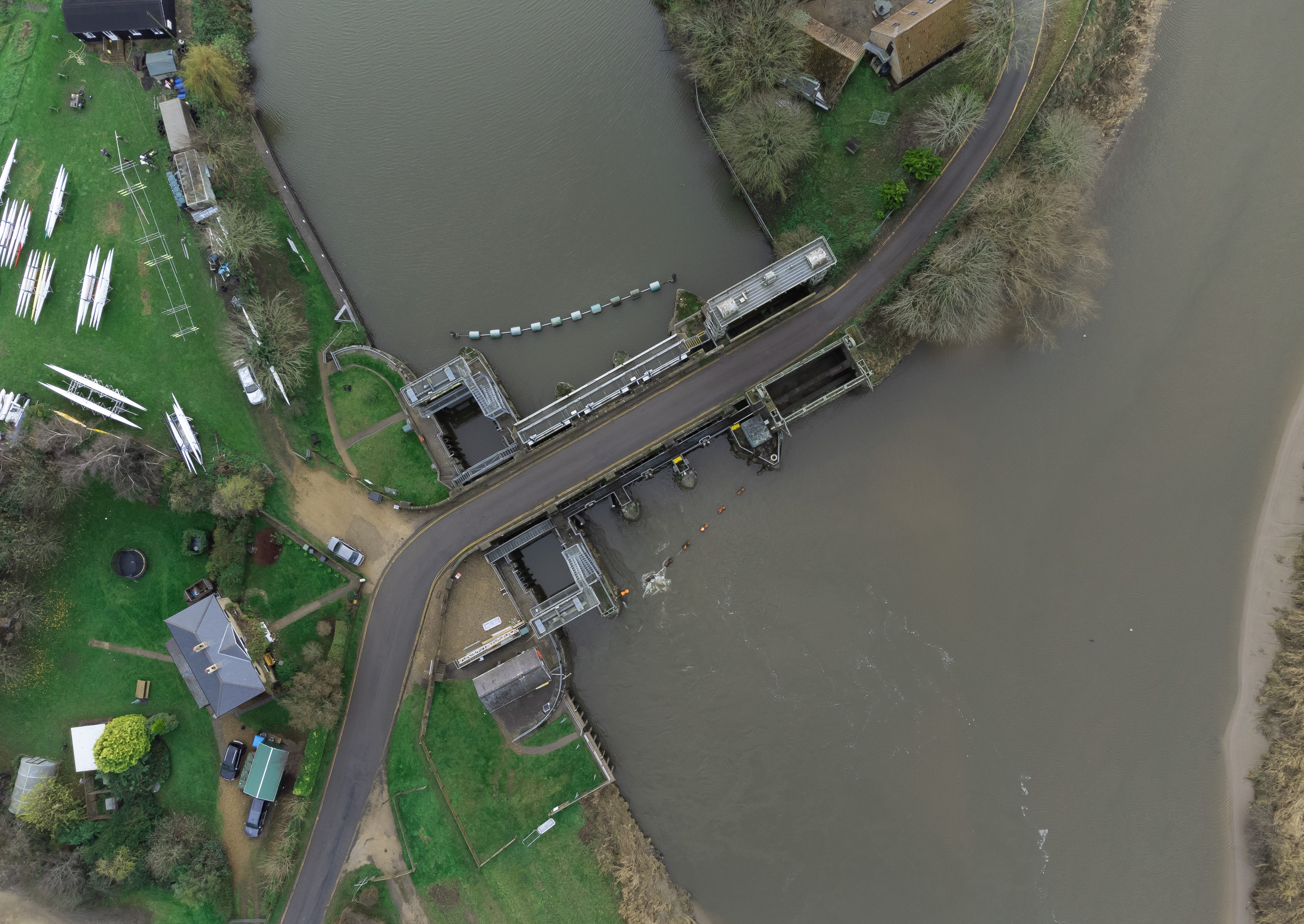
Denver Sluice near Downham Market, Norfolk. This sluice plays a key role in the drainage of the fens and also to control tidal water.
This picture was taken today Sunday 12th December with my Mini2 at 120 mts (400 ft).
Great shot  in 2020
Just a wee bit outside the comp period 
To be honest really haven’t got out much this year with work commitments
Stick a bird up 400 feet as you are leaving for home - treat us to a night shot of where you work
I haven’t taken many straight down shots in the past and am surprised at how little shows up in the image , I will have to consider my subject carefully
He might work at HMP ![]()
Legally speaking, it’s easier to fly above a prison (restrictions apply to helicopters, not drones) than above vast areas of empty landscape like the Peak District (because of bye-laws).
Because as a country our laws make total sense. ![]()
Top down image of sea defences at Porthcawl, taken yesterday with MM, not entirely sure what height I was as I was more focused on how strong the wind was 
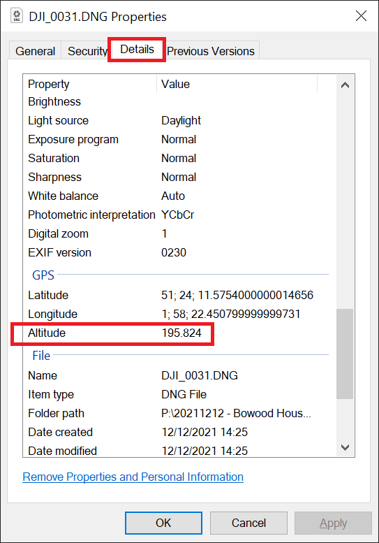
It will show you in the properties of the image. Normally, you would have to subtract the place’s elevation above sea level - but doesn’t really apply for this shot ![]()
Using Firefox with the snappily titled Display picture meta-data extebsion we get variable results according to how a picture is presented. It seems that if it’s cropped we lose a lot of information.
Rich’s picture is uncropped so we got a fairly full read on data - except the altitude looks a wee bit off:

To be within the bounds of the title we would accept any sufficiently high shot - anywhere between 399.51 and 400.49 feet …
Just noticed why. Metadata does not show a minus lng.
I was just typing a reply tto your firdt comment Chris when I saw you had seen the error. What are you using to pull metadata from pictures? Is it a Chrome or Firefox extension - it seems a little better than the one I’m using.